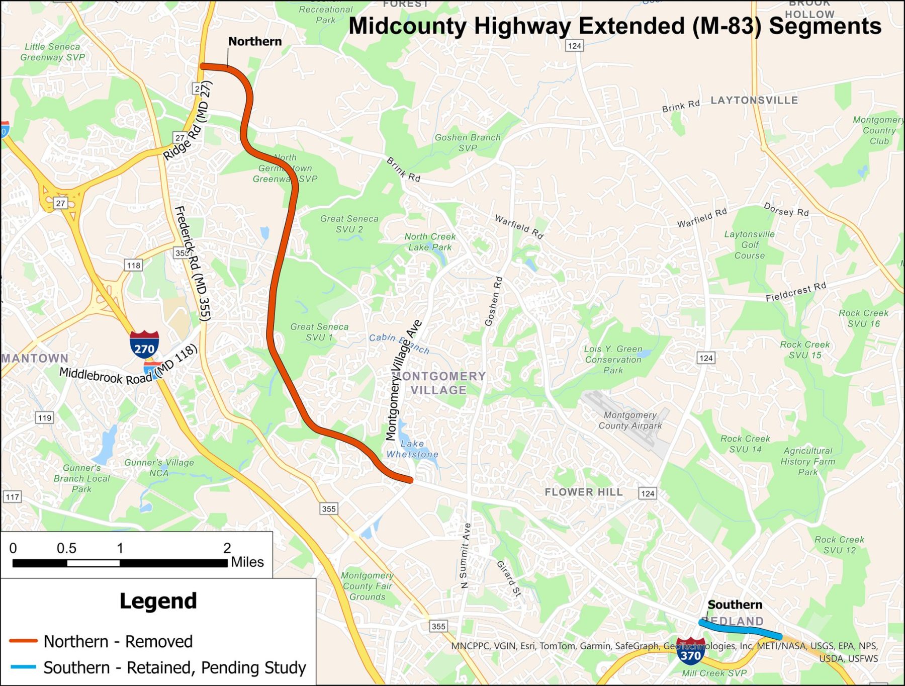
Midcounty Highway (M-83) was first included in Montgomery County’s Master Plan of Highways in the 1960s. It is planned to extend from Ridge Road (MD 27) in Clarksburg to Redland Road in Derwood as an 8.7-mile, controlled access, four to six-lane major highway. Over the years, a three-mile segment of Midcounty Highway was constructed between Shady Grove Road and Montgomery Village Avenue as well as a short two-lane section from Middlebrook Road to Grassy Knoll Terrace. Right-of-way is preserved on much of the unbuilt sections of the proposed highway.
On November 21, 2013, following publication of MCDOT’s Draft Environmental Effects Report, the Planning Board received a briefing by M-NCPPC staff and Montgomery County Department of Transportation (MCDOT) staff and heard public testimony. As a result of the November 21, 2013 briefing and testimony, the Planning Board issued a letter to MCDOT supporting Alternative 9A, the master plan alignment. In 2015, MCDOT completed the Draft Preferred Alternative/Conceptual Mitigation Report, also recommending Alternative 9A as the Preferred Alternative.
In 2017, MCDOT completed the Midcounty Corridor Study Supplemental Report, evaluating three options that included transit. The analysis found that a transit-focused scenario, including bus rapid transit (BRT) on MD 355 and local intersection improvements, could accommodate a large share of the future transportation needs along the corridor.
Later that year, the County Council issued Resolution 18-957, directing the Planning Board “not to assume additional road capacity from the northern extension of Midcounty Highway when calculating the land use – transportation balance in future master plans, including but not limited to the upcoming Gaithersburg East Master Plan and the Germantown Plan for Town Sector Zone. This step ensures that any new development allowed under these plans does not rely on the northern extension of Midcounty Highway, while retaining the right-of-way for this extension in these plans.” MCDOT subsequently place the project on hold.
Latest news on Midcounty Highway (M-83)
A major theme of the testimony received at the 2024 update to the Master Plan of Highways and Transitways (MPOHT) public hearing on September 12, 2024, was to remove the unbuilt sections of Midcounty Highway Extended, including the northern extension between Montgomery Village Avenue and Ridge Road, as well as the southern extension between MD 200 and Shady Grove Road, from the master plan. As doing so was beyond the plan’s approved scope of work, a briefing was provided to the Planning Board on October 3, 2024, to consider how to address this feedback. At that meeting, the Planning Board voted to modify the scope of work to consider removing Midcounty Highway Extended (including the adjacent unbuilt bikeway) from the master plan and to hold a second public hearing. The hearing date is set for Thursday, November 14, 2024.
Follow the 2024 MPOHT for updates and information on M-83.
At the conclusion of three public hearings, planning staff summarized all comments received between June 26, 2024 and January 24, 2025. Each comment was reviewed and draft responses were provided by Planning Staff. The focus of the next series of work sessions was to discuss key comments received, share the planning staff rationale for each key comment, and modify as directed by the Planning Board. Work sessions were previously held on two dates with two upcoming dates remaining:
- February 13, 2025: View the video and staff report
- March 6, 2025: View the video and staff report
- March 20, 2025: View the staff report
- April 10, 2025: Materials will be provided after April 3
Draft recommendations on Midcounty Highway Extended:
- Remove the northern section of M-83 from the MPOHT as it is inconsistent with Thrive Montgomery 2050 and the county’s Climate Action Plan.
- Conduct a comprehensive study of travel needs along the Clarksburg to Germantown corridor to determine if there is sufficient master-planned transportation capacity to accommodate planned development.
- Retain the southern section of M-83 between Shady Grove Road and the Intercounty Connector (ICC) until a more detailed planning and engineering feasibility study can be completed.
Resolution on status of northern segments of Midcounty Highway Extended
At the conclusion of the first session on February 13, the planning board approved the following recommendations:
- Remove the northern section of Midcounty Highway Extended from the MPOHT as it is inconsistent with Thrive Montgomery 2050 and the Climate Action Plan.
- Conduct a comprehensive study of travel needs along the Clarksburg to Germantown corridor to determine if there is sufficient master-planned transportation capacity to accommodate planned development.
Work Session #1 was dedicated entirely to the issue of Midcounty Highway Extended (M-83) so the data and presentation that led to this decision are provided in the planning board video and in the work session #1 staff report.
Work Session #2 primarily focused on other comments and recommendations in the MPOHT not related to Midcounty Highway Extended (M-83). However, planning staff also demonstrated a new webapp to show Clarksburg to Germantown Transportation Infrastructure. This map provides information on existing and proposed transportation infrastructure in the area. This map provides information on existing and proposed transportation infrastructure, including the proposed Scenario 1 from the 2017 Midcounty Corridor Study Supplemental Report.
During the first work session the Planning Board requested a better understanding of the status of transportation infrastructure in the Clarksburg to Germantown area. In response, Planning Staff develop a GIS web application that shows the existing and planned highways, transitways, and bikeways in this portion of the county, with one map for each mode. Each map symbolizes features based on its “Status,” summarized as follows:
- Fully Constructed – Post 2019
- Fully Constructed – Pre 2019
- Partially Constructed
- Not Constructed – Funded for Construction
- Not Constructed – Funded for Design
- Not Constructed – Approved Development
- Not Constructed – Master-Planned Only
Resolution on status of southern segments of Midcounty Highway Extended
At the conclusion of Work Session #3 on March 20, 2025, the planning board approved the following recommendation: that the southern section of Midcounty Highway Extended (M-83) between Shady Grove Road and the ICC be retained in the Master Plan of Highways and Transitways until a more detailed planning and engineering feasibility study can be completed. Planning Staff also summarized preliminary concepts for a comprehensive study of travel needs along the Clarksburg to Germantown corridor to determine if there is sufficient master-planned transportation capacity to accommodate planned development.
At Work Session #4 on April 10, 2025. the Planning Board reviewed the final draft of the plan and authorized staff to publish and transmit the revised draft as the Planning Board Draft to the County Executive and the County Council.
Frequently asked questions
As of January 2025, much of the Midcounty Highway Extended right-of-way has been preserved through public ownership, the construction of other parallel and intersecting roadways, and dedication for public use by private property owners as part of the development approval process:
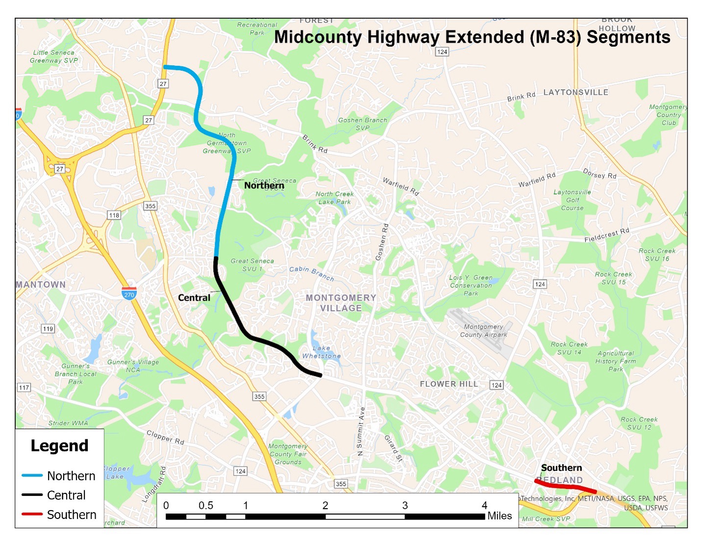
- Northern Segment: Between Ridge Road and Germantown Road, 75% of the alignment is preserved. However, of this, 29% is dedication, which could be lost if Midcounty Highway Extended is removed from the Master Plan of Highways and Transitways.
- Central Segment: Between Germantown Road and Montgomery Village, 84% of the alignment is preserved. However, of this, 53% is dedication, which could be lost if Midcounty Highway Extended is removed from the Master Plan of Highways and Transitways.
- Southern Segment: All of the southern segment, between Shady Grove Road and the Intercounty Connector, is fully preserved in public ownership or as part of existing roadways and would not be lost if Midcounty Highway Extended is removed from the Master Plan of Highways and Transitways.
| Category | Northern | Central | Southern | Total |
| Public Ownership | 41% | 24% | 79% | 40% |
| Existing Roadway | 6% | 7% | 21% | 8% |
| Dedication | 29% | 53% | 0% | 34% |
| Private Ownership | 25% | 16% | 0% | 18% |
| Total | 100% | 100% | 100% | 100% |
No. However, the Planning Board would continue to be able to require dedication for other public uses that remain in the Bicycle Master Plan, Upper Rock Creek Are Master Plan, the Gaithersburg Vicinity Master Plan, Montgomery Village Master Plan, the Germantown Master Plan, and the Clarksburg Master Plan, such as bikeways and trails.
Nothing happens to the right-of-way unless the County Council or the Planning Board approves an abandonment of the right-of-way. After the abandonment, the land area would revert back to use by the adjacent property that made the original dedication.
There are two processes for abandonment. If the right-of-way is in public use, the County Council reviews and approves abandonments pursuant to Chapter 49-62, et seq of the County Code.
If the right-of-way has not been in public use, the Planning Board reviews abandonment applications via a preliminary plan application pursuant to Chapter 49-68 of the County Code.
Nothing, the bikeway planned in the right-of-way would continue to be recommended in the Bicycle Master Plan and therefore, the right-of-way preserved for the bikeway would be retained. However, the right-of-way requirements of a bikeway are substantially less than the highway. On flat land the right-of-way could be as narrow as 30 feet for a bikeway, including shoulders, though the right-of-way may be greater on segments with steep slopes that could require switchbacks.