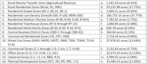
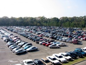
Zoning
Current Zoning in Montgomery County
On March 7th the Planning Board began the final phase of its worksessions on the proposed zoning code: implementation and impacts of the new code. After more than 4 years of blood, sweat, and tears (mostly figuratively speaking), a Revised Preliminary Planning Board Draft has been released. After several final worksessions and concluding public hearing, a Planning Board Draft Zoning Ordinance will be sent to the County Council for introduction in early May.
During the past few years Planning Department Staff has followed an extensive outreach strategy that has included:
- Over 80 public meetings,
- Dozens of Planning Board worksessions,
- Numerous Council presentations,
- Regular email âblastsâ to hundreds of parties following the project,
- Press releases for project milestones,
- Almost weekly web site and agenda updates, and
- Direct mailings to over 9,000 property owners of commercial, industrial, and other properties.
This outreach has led to great input and a lot of good ideas have been incorporated into the zoning ordinance. But we would like to get even more input in order to produce the best document we can for the Councilâs consideration. Please take the time to look through the draft ordinance, take a look at the material on our website, or give us a call or send us an email with any particular questions. We even have office hours set up for you to come in and discuss what implementation of the new ordinance may mean to you.
To encourage further discussion and to explain a few particularly complicated and misunderstood issues, I will be posting a series of blogs over the next couple months. I will at least cover the topics listed below, but am happy to post on other topics that folks have questions or concerns about.
Zoning Rewrite Blog Topics
- How is the County Currently Zoned?
- Zoning Text and Zoning Map Amendment Public Notice Requirements
- The Difference between Building Types and Uses
- The Difference between Permitted, Limited, and Conditional Uses
- What Changes are Proposed to the Small-Lot Residential Zones?
- Why do the Proposed Zones Have So Many Letters and Numbers?
- Sustainability Initiatives in the Proposed Code
- Agricultural Support in the Proposed Code
We look forward to continued dialog; schedules on worksessions, hearings, and comment periods will be posted as dates are set.
Some Recent Articles & Links
On Housing
- A report from the Brookings Institution: restrictive (read, âexclusionaryâ) zoning may lead to lower test scores for kids.
âAs the nation grapples with the growing gap between rich and poor and an economy increasingly reliant on formal education, public policies should address housing market regulations that prohibit all but the very affluent from enrolling their children in high-scoring public schools in order to promote individual social mobility and broader economic security.â
- An analysis by US Today shows the recession accelerated trends towards urbanization.
âThe shift to more urban housing development has been growing slowly during the past couple of decades and thanks to the recession and housing crash, this trend has accelerated. It is probable that the trends that the USA Today analysis points to are the precursors to a long-term shift in suburban development resulting in more in-fill, close-in development and far less growth on the outer edges of metropolitan areas.â
- Downtown Cleveland is growing while suburban/exurban growth slows or reverses course.
âTake the latest population figures in the 5 county metropolitan area [around Cleveland]. From 1990 to 2010, the City of Cleveland shrank, as did many of the suburban areas of Cuyahoga County. The growth mostly occurred in the increasingly exurban fringes of the metro, as well as on the edges of Cuyahoga County. Except there is one outlier: downtown Cleveland. Over the last two decades, the neighborhood’s population grew 96%, with residential totals increasing from 4,651 to 9,098. It was the single largest spike of any neighborhood, suburb, or county measured for the two decades under study.â
Defining Neighborhoods through Data Tracking
ââŚa research project called Livehoods, from Carnegie Mellon University’s School of Computer Science, aims to shed some light on how people really inhabit their citiesâand how this changes over timeâby mapping data collected from 18 million Foursquare check-ins that have been sent out via Twitter.â
ITDP Mexico Takes on Traffic
Rethinking the National Mall
âMany of the worldâs top landscape architects and architects presented their designs for three grand projects on the National Mall: Constitution Gardens, Union Square, and the Washington Monument Grounds at Sylvan Theatre. The competition is fierce because all the design proposals offer elegant, exciting, innovative ideas for solving sticky ecological, security, and public space design challenges.â
Blog.
Creativity & Cities
Jonah Lehrer’s ambitious new book, Imagine: How Creativity Works, takes a fascinating dive into the world of creativity and how it all works, not to mention devoting a chapter entirely to cities.
Lehrer recently took some time to chat with Atlantic Cities and expand on his ideas concerning the nexus of creativity and cities.
Urban Agriculture
Urban agriculture has a number of advantages for communities, including:
- improving the quality of the urban environment through the introduction of green space and, thus, a reduction in pollution and global warming;
- supporting the reduction of energy use through local production of food, including savings in transportation costs and food storage. Purchasing produce from farmers within a 100-mile (160-km) radius reduces automobile emissions and eliminates packaging waste;
- helping close the urban loop system characterized by importation of food from rural zones and exportation of waste to regions outside the city or town;
- incorporating use of wastewater for irrigation and organic solid waste for fertilizer;
- promoting alternative development options, such as cultivation of vacant urban land for agricultural production;
- helping build equitable responses to food needs by providing local food sources for low-income communities to improve access to fresh foods;
- invigorating the community by incorporating local ideas and engagement; and
- incorporating a cross-sector approach to look at long-term, systemic solutions to problems in cities with the goal of improved health and wellness.
Transit Score
Guess whoâs ahead of Portland? And whoâs right behind?!
Book(s) of the Month: City Life
In my last post, I began reviewing two of my favorite books from Witold Rybczynski, someone I consider one of the best authors in architecture and urban studies. The first post covered Last Harvest (2007) . Contrast that to City Life (1995), where Rybczynski theorizes:
ââŚthe American city has been a stage for the ideas of ordinary people: the small business man on Main Street, the franchisee along the commercial strip, the family in the suburbs. It all adds up to a disparate vision of the city. Perhaps the American urban stage is best described as cinematic rather than theatrical. A jumbled back lot with cheek-by-jowl assortment of different sets for different productionsâŚ.â
Like Last Harvest, there are many digressions along the way. In this case into:
- Etymology
- Overviews of works by Lynch, Mumford, Sitte, and others
- Design impacts of Burnham and Olmsted
- Paradigmatic urban forms
- Expansion of Fernand Braudelâs theory of stages in city development to include industrial, post-industrial, and information-age cities
- The Laws of the Indies
- De Tocquevilleâs visit to the States
- The Land Ordinance of 1785
- Immigration
- Real estate speculation
- The Columbian Exposition and the Civic Art (City Beautiful) movement
The interesting contrasts Rybczynski describes between North American and European cities have a lot to do with the fact that the New World was basically (to the colonists) a blank slate. But there were important differences between Hispanic, French, and English colonial urbanization that resulted in patterns that last into the 21st century.
Wonderful brief histories and analysis are provided on cities as diverse as Saint Augustine, Quebec, Montreal, New Orleans, New York, Boston, New Haven, Charleston, Annapolis (a high-point in early planning thanks to our early governor, Francis Nicholson), Williamsburg, Philadelphia, Savannah, Woodstock, and Chicago. From these precedents, Rybczynski draws several generalities that distinguish North American cities dating back to their roots. Because land was cheap, âemptyâ and populations were sparse, people spread out. Open space was treasured, resulting in broad streets and public squares â the desire for spaciousness was built into our psyche in the infancy of our republic. Also, grids established an easy form of real estate development and the commodification of land. The imprint of religious tolerance and democratic governance can be found in the patterns of open spaces, relationships of civic and institutional buildings, and the focus on individual lots for houses.
A large impact on the form of our cities is, of course, functional zoning that separates uses and robs places of variety and vitality. Thus, a good many pages are devoted to early zoning ordinances (Los Angeles â 1907 and New York â 1916), building heights, and uses. In large part, as a reaction to the Civic Art ideals, the First National Conference on City Planning in 1909 deemed attempts to beautify cities âas exercises in âcivic vanityâ and âexternal adornment.â The bureaucrats and engineers felt that city planning should be concerned with engineering, economic efficiency, and social reform, not aesthetics. They asserted that whatever functioned well would automatically produce a beautiful, or at least acceptable, urban environment.â Sigh, we still suffer from the results of such thinking.
A large portion of the second half of the book details the tensions between competing theories, governmental policies, and the flight of the population to the suburbs. All of these intertwined ideas are told, of course, through a wandering history with anecdotes, observations, and citations from numerous practitioners, government acts, and examples. These ideas are fleshed out in more detail in Rybczynskiâs latest book, Makeshift Metropolis.
The final two chapters address the revitalization of downtowns and an approach Rybczynski calls âThe Best of Both Worlds.â His paradigm is his home in Chestnut Hill in northwest Philadelphia. Chestnut Hill has several attributes:
- A diverse housing stock including multi-family, townhouse, and detached houses
- A population of about 10,000 people within less than 3 square miles (about 5 people per acre)
- A commercial main street
- Strong connections to Philadelphiaâs cultural and business core and the greater metropolitan area
These attributes point to a networked system of mid-size centers within greater regions, but will require connections â electronic and physical â to each other with multi-modal transit, smart power grids, and numerous other more sustainable infrastructure upgrades that we need to begin planning for now.
Parking is one of the single-most controversial aspects of development splitting generally along the lines of “we don’t require enough” versus “we require too much”. Parking management is an issue that affects congestion, pollution, pedestrian comfort & safety, potential for open space and green areas, business revitalization feasibility, and many other topics. With so many factors being effected, it’s probable that no model we develop will make everyone (or maybe anyone) completely happy. But it is our task to try.
As many know, the parking ratios we apply to commercial uses have not been updated for decades. And our shared-use model is still based on maximum demand. With this in mind, the County’s DOT and MNCPPC were directed to work with a consultant to examine our existing practices and develop new ideas for establishing parking ratios in our mixed-use/commercial zones. Their report was developed over several months and presented to the Planning Board, County Council committees, the Zoning Advisory Panel (which advises the Planning Department on the ongoing zoning ordinance rewrite), and numerous stakeholder groups of citizens, property owners, developers, bike/transit advocates, and agencies.
The study was focused on Division 59-E (parking requirements) and Chapter 60 (parking lot district [PLD] regulations) of the County Code and our consultant, Nelson/Nygaard, was tasked with several objectives including to:
- Update the PLD program;
- Assess current PLD performance;
- Identify opportunities for PLD improvement;
- Assess interaction between 59-E and 60;
- Update current 59-E requirements;
- Promote shared parking;
- Support local business;
- Increase flexibility; and
- Make standards clearer and more predictable.
A large amount of the initial phase of the study was focused on analysis of our code, best practices in other jurisdictions, and professional models. Some of the more innovative practices included:
- No minimum parking requirements such as Ann Arbor, MI (Public Parking & TDM Strategies Plan);
- Flexible parking pricing such as in San Francisco (SF Park);
- Broad use of employee transit benefits and assurance that parking revenues target local transportation-related investments such as Boulder, CO (Parking Best Practices Review);
- Targeting parking revenues to streetscape improvements to increase pedestrian comfort and safety such as Pasadena, CA (summary at walkablestreets.com); and
- Obtaining shared parking in private development such as Arlington, VA (Columbia Pike Parking Strategy).
Also, the latest industry models from the Urban Land Institute and Institute of Transportation Engineers were studied and compared side-by-side with the benchmark peers, best practice codes, policy-based models, and density-based models. (See the Appendices of the Report for more details.)
After a thorough analysis of the existing code, data on local usage and revenue, and the practices outlined above, a model was drafted. Part 2 will lay out the basics of this model.
Post Script: My vote is for public art integrated into every garage….
On a recent trip for my auntâs wedding, I had a chance to stop by my grandparentâs place in a small town in CT. One of the first things I noticed, being who I am, is that the community open space was either play space or community garden space. My grandmother, of course, has a small plot where she can grow flowers and some veggies and generally keep active in a town where there isnât much else to do â especially for seniors (or kids, for that matter). I don’t think we can overstate how important connections to nature and food are and how community gardens, playgrounds, and open space bring people together and promote health, well-being, happiness, etc. The American Community Gardening Association has summarized the benefits well:
Benefits of Community Gardens:
- Improves the quality of life for people in the garden
- Provides a catalyst for neighborhood and community development
- Stimulates Social Interaction
- Encourages Self-Reliance
- Beautifies Neighborhoods
- Produces Nutritious Food
- Reduces Family Food Budgets
- Conserves Resources
- Creates opportunity for recreation, exercise, therapy, and education
- Reduces Crime
- Preserves Green Space
- Creates income opportunities and economic development
- Reduces city heat from streets and parking lots
- Provides opportunities for intergenerational and cross-cultural connections
But, even without space for community gardens (as with most infill, gray-field projects), we can still benefit from creating our own little Edenic plots. A number of urban gardening stories have come across my desk/mailbox/computer recently; two that I’ll pontificate on here.
Wired magazine had an interesting story on creating gardens at various scales â from balcony to suburban lot. What was key to each of the scales was maximizing productivity (and luring nerds into the green-geek world of botanical names, grafting techniques, soil science, etc. of gardening). One aspect that didnât escape my attention was the fact that virtually all the scenarios involved keeping animals of one kind or another, which is generally verboten in most of our denser residential and mixed-use zones. Is there tolerance to change this? Maybe step by step: bees, chickens, rabbits, goatsâŚâŚ
Which brings me to a video I came across on an intensive farm created on an abandoned lot in Oakland, CA. In this case, the admitted state of anarchy in the area has allowed the gardener to be left to her own devices â the cops have better things to do. But, as the example shows, if the garden is technically illegal, doesnât the fact that it co-exists peaceably, and may even be fostering some community bonds tell us something about our squeamishness regarding farming in urban areas? Many cultures live in and around their food sources. We generally donât â our landscapes are aesthetically focused. Itâs a shame we havenât yet integrated the productive values of landscapes (ecologically, socially, nutritionally, economically) with our typically English pleasure garden aesthetic. Again, step by step: corn in the front yard, espaliered trees along fences rather than evergreen hedges, strawberries in our container plantingsâŚ..
Iâm looking forward to keeping this conversation going during our zoning rewrite process and Iâll be interested to know what our tolerance really is. Can we put our farms where our mouth is?
As we start writing the code for the new zoning ordinance, a âbig pictureâ view seems in order. The biggest-picture formula in climate change, called the Kaya identity, is:
- F = Global CO2 emissions (combustion, flaring of natural gas, cement production, oxidation of nonfuel hydrocarbons, and transport)
- P = Global population (total number of human beings)
- g = Consumption per person (gross world product divided by population)
- e = Energy intensity of gross world product (global energy consumption divided by gross world product)
- f = Carbon used to make energy (global carbon dioxide emissions divided by global energy consumption)

Factors in the Kaya identity, F = Pgef = Pgh, as global averages. All quantities are normalized to 1 at 1990. Intensities are calculated by using G M (Left) and G P (Right). In both Left and Right, the black line (F) is the product of the red (P), orange (g), green (e), and light blue (f) lines (Eq. 2) or equivalently of the red (P), orange (g), and dark blue (h) lines (Eq. 3). Because h = ef, the dark blue line is the product of the green and light blue lines. Source: PNAS.
The most obvious thing about this equation â if you remember even grade-school math â is that to reduce F to zero, any of the four factors on the right must go to zero. Since even the most misanthropic earth-firster has not suggested that global population should be reduced to zero (or if they have and taken their own advice, they arenât here to argue against me), efforts at reducing F should concentrate on the areas where we can have the most impact.
Here are a few basic suggestions on the issues over which we (planners and designers) have influence.
We can minimize g & e (consumption-related factors) by:
- Decreasing the need for energy for transport by co-locating as many jobs, houses, services, and amenities as is practical;
- Providing resource-sharing opportunities (like mass-transit and libraries);
- Allowing for development with minimal resources (one wall between two residences requires less resources than two walls and a strip of grass);
- Allowing for optimally efficient building siting (donât penalize development with setbacks or height restrictions when those features are used to optimize passive energy use);
- Encouraging recycling, reuse, and retrofits of existing infrastructure;
- Providing flexibility for more locally-sustaining economic development (farms, markets, co-ops, craftspeople and artisans, localism generally);
We will have to wait for the scientists to provide an f that equals zero, but we can help minimize f (carbon use for energy) by:
- Ensuring that rules donât get in the way of technology that uses renewable energy sources (geothermal, wind, solar); and
- Providing incentives to encourage use of the available renewable energy sources.
Thanks to Wired for reminding me of the useful perspective provided by this formula as we look to finalize some thoughts on sustainability and our zoning code rewrite efforts. Further suggestions to add to the list above are, of course, welcome.
Reminder: May 27, 7:30 ReThink Energy w/A. Michael Schaal.
Lately, I’ve been discussing the effort to rewrite Montgomery County’s zoning code. Previous installments have covered zones and uses. Today, I discuss issues that make the current code complex and disorganized.
Deficient Definitions
Like most legal documents, the Montgomery County Zoning Code includes a definitions section. But like other parts of our code, this section has also become cluttered and disorganized.
Montgomery’s code includes 25 defined terms that are not used in the text of the code. “Foster home,” “marquee,” and “roof line” all fall into this category; the meaning of each is clear â because they’re defined â but they are never referenced in the code.
Of the multitude of office types listed as permitted uses, only three are defined. The definition of “offices, general” includes “offices, insurance claims.” But “offices, insurance claims” is its own line item in our use tables and is not itself defined. What happens if “offices, general” is permitted in a zone, but “offices, insurance claims” is not (in the C-4 zone, for instance)?
At the same time, the code deals with many terms that are not defined. Despite several specific and general categories of retail, the code doesn’t clarify what is included in retail. Other words, for which a definition might be helpful, include “impervious surface,” “Priority Funding Area,” and “streetscape.”
Procedures
When Montgomery’s first zoning code was enacted in 1928, development procedures were basically limited to an occupancy certificate, building permit, and plat. Today, there are 13 different procedures, some of which are similar (with different names) but are sometimes applicable on a zone by zone basis. Many procedures overlap with other procedures, as well.
The large number of procedures makes it difficult for everyone. It’s difficult for property owners and developers to understand which plans and processes they’re subject to and is difficult for citizens to know when they have the opportunity to participate in the process.
Procedures include:
- Development Plan
- Diagrammatic Plan
- Schematic Development Plan
- Supplementary Plan
- Pre-Preliminary Plan
- Urban Renewal Plan
- Project Plan
- Preliminary Plan
- Site Plan
- Record Plat
- Variance
- Special Exception
Development Standards
Development in the county is regulated by a set of standards in each zone. These standards regulate everything from height and density to setbacks. They are often very complicated and difficult to understand. Any given development could face up to 60 standards.
Standards also regulate open space. In some zones, this is called “green area,” which is misleading in and of itself, because it can include paved areas and structures. In other zones, this area is variously referred to as “public use space,” “common open space,” and “outside amenity area.” The terminology is inconsistent.
Oftentimes, standards no longer make sense or use outdated methods to achieve an end. For instance, in some residential zones, a requirement exists for a minimum 12-foot side yard setback, and that the sum of the setbacks must total 25 feet.
Some of the requirements, especially different definitions of density for residential and commercial components discourage mixed use. Defining residential uses by units per acre, but commercial development by Floor-Area Ratio (FAR) adds unneeded complexity to the process and does not result in predicable results.
Over the years, Montgomery County’s zoning code has lost its cohesive vision. The tools in our planning toolbox no longer match the critical tasks at hand, which are all the more as the county runs out of greenfield areas to develop.
In the next installment, I’ll discuss the approach we’re taking to write the new code.
Cross-posted at Greater Greater Washington.
Montgomery’s zoning issues, part 2: Uses
Montgomery County is working to rewrite its aging and complicated zoning code. In the last installment, I discussed problems with our zones. This post looks at issues facing allowable uses.
Zoning codes determine which land uses are or are not allowed to operate in each zone. Montgomery County’s code deals with allowable uses by organizing them into tables or lists. Each zone or group of zones has a use table, list, or combination. The lack of standardized presentation of uses is part of the problem.
In each zone, uses, such as book stores, bowling alleys, recycling facilities, and townhouses, are either permitted by right or special exception, as indicated in the tables.

The use table shows uses on the left, zones on the top. Uses are permitted by right if they have a "P" and are special exceptions with an "SE"; they are not allowed if blank.
Our use tables, however, are not very user-friendly. If you know the zoning of a property, you can easily figure out what is permitted. However, if you want to know in what zone your new enterprise will fit, the tables won’t shed much light.
Montgomery’s code lists 433 specific uses. However, many of them are duplicative, overlapping, or outdated. The code lists 18 different types of office, including “offices, business,” “offices, insurance claims,” “offices, general,” “offices, professional,” and “offices, professional and business.”
There are nine different types of child care, three different types of antique stores, and three different listings for Christmas tree sales. Do we really need an individual use for each variation of an antique shop?
Abattoirs, blacksmiths, foundries, millinery shops, and variety stores are all listed as permitted uses. Not only did most of those uses disappear from Montgomery County a century ago, but do people really know what those terms mean?
The modern term for abattoir, incidentally, is “slaughterhouse.”
Oddities abound. Permitted uses in the I-2 (heavy industrial) zone include “stove polish” and “starch, glucose and dextrin.” The code doesn’t say the manufacturing of stove polish and starch, glucose and dextrin are permitted; it says those things are permitted. Does that mean one can use them in manufacturing? One can store them? Produce them? The code simply does not provide answers to these questions.
Like the rest of the code, our use tables are the victims of unplanned additions and amendments. As new zones were added, uses were removed, added, and modified without consideration for the overall form or goals of the code. If a use category wasn’t broad enough, often times, a new specific use was inserted. And sometimes, use categories would be amended in one place but not another.
These issues need to be addressed. However, our approach must be more than just a revision of the existing use tables. The county’s approach must be one which will deter subsequent haphazard and complicating additions or modifications. Our goal is to provide more certainty in the zoning process. Property owners, neighbors, and builders must know as much up front as possible, to help simplify the process and achieve more predictable results.
Cross-posted at Greater Greater Washington.
Recently, I discussed the effort underway in Montgomery County to rewrite an aging zoning code. Over three decades, the code has grown unwieldy and hard to use. Thirty-three years of additions and amendments has left the code with a mess of outdated provisions, orphaned words, and a baffling table of permitted uses.
Many of the problems with the code stem from shortsightedness and the simple march of time. Text amendments and new zones were added without regard to the goals and intent of the code. As older zones fell into disuse, they were not refined or removed. At the same time, planners devised new zones for many of the master plans.
The result: a ballooning in the size and complexity of the code. In 1977, when the code was last rewritten, it spanned 274 pages. It’s now over 1,000 and grew by 100 pages in 2008 alone.
Proliferation of zones
Among the most well-known aspects of any zoning code is the large array of zones themselves. In 1977, the county had 41 zones. Today, we have 120 zones, including 15 overlay zones.
At least 12 zones are totally unused, including six Planned Development zones which may never have been used. Some zones are similar to other zones, and thus are barely used.
Furthermore, the creation of mainly single-use, special-purpose zones has contributed to the proliferation. The H-M zone, for instance, was created for hotels and motels. But hotels and motels are permitted by right in 10 other zones. In fact, only two of Montgomery County’s hotels are even in the H-M zone. That zone takes up just 21 acres, well under 0.1 percent of the county’s land area.
Similarly, the mixed use, commercial, and central business district zones make up only 1.3% of the county’s land, but account for over 20% of the county’s zones. On the other hand, the Agricultural Reserve takes up almost 38% of the county’s land, but is made up of just one zone: RDT.
Several zones are almost identical in composition. R-150 and R-200 are both low density residential zones, and have very little differences between them. While R-200 makes up 13% of the county’s area, R-150 makes up only 0.4%.
Simplifying our zones is one step we are working on to make the code easier to use. In a future installment, I’ll talk about our thoughts on zones. It is clear that development in the county will increasingly be located in infill situations where the current standards may prevent good infill development. The new zoning code will help create building and land typologies that will result in predictable infill development.
Cross-posted at Greater Greater Washington.


