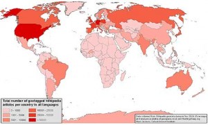
What would one notice if a map was created based on the geographical entries in Wikipedia? A confirmation that “we” [viz., the countries in dark red below] are more interested in ourselves than other places.
This may be obvious, and not necessarily self-serving, but it does point to our lack of knowledge of other places and peoples. In any event, the visualization of this information is a pointed reminder that much of the world isn’t even involved as part of the conversation on knowledge and information. If nothing else, we should remember this when we speak of “the greater good”.
THE THIRD PLACE
In planning, the third place is the social realm separate from home and the workplace.
It provides an inclusive forum for dialogue crucial for civic engagement and community building.
Sign up for our newsletter
Sign up for Parks+Plans, the official weekly e-newsletter of the Planning Department and Department of Parks: