View full Public Hearing Draft. View an interactive map of the zoning recommendations. (Updated July 16, 2025)
Land Use, Zoning, and Urban Design
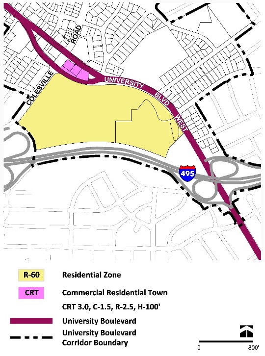
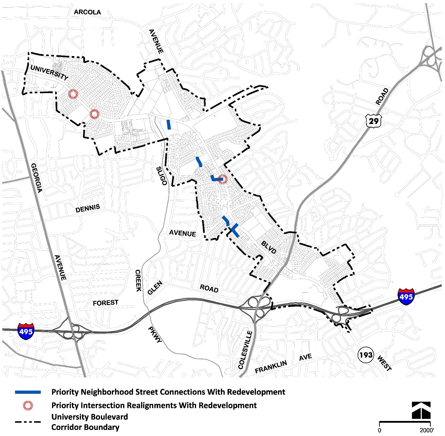
Amherst Avenue and Chestnut Ridge District
The Amherst Avenue and Chestnut Ridge District generally extends from Amherst Avenue at the edge of the Wheaton Central Business District to Sligo Creek Stream Valley Park and includes the following neighborhoods: WTOP, Hearthstone Village, and Inwood House.
Amherst Avenue and Chestnut Ridge District
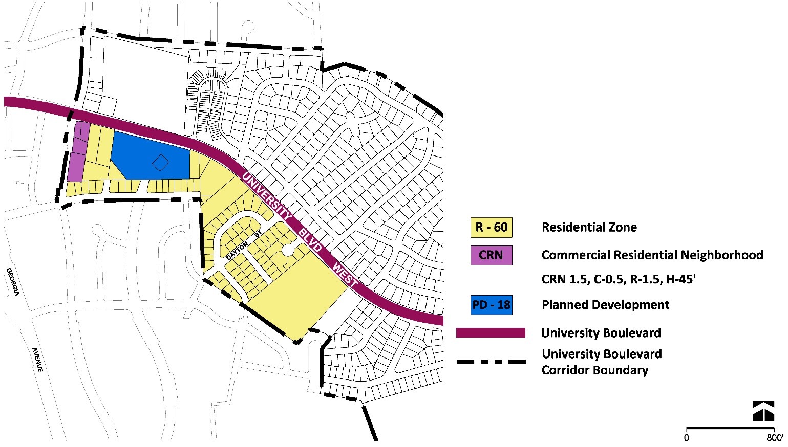
WTOP Neighborhood
Land Use and Zoning Recommendations
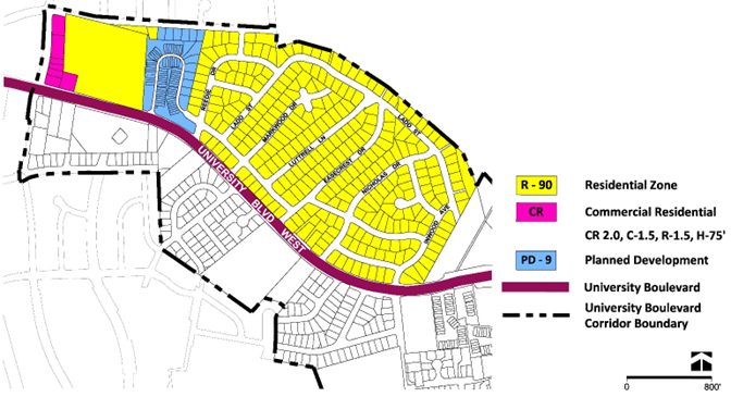
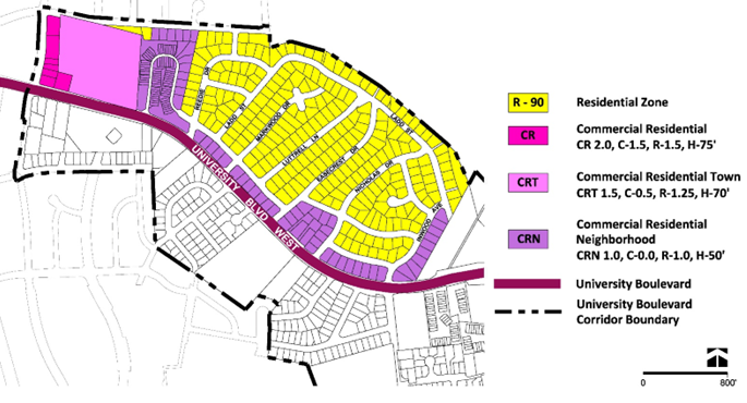
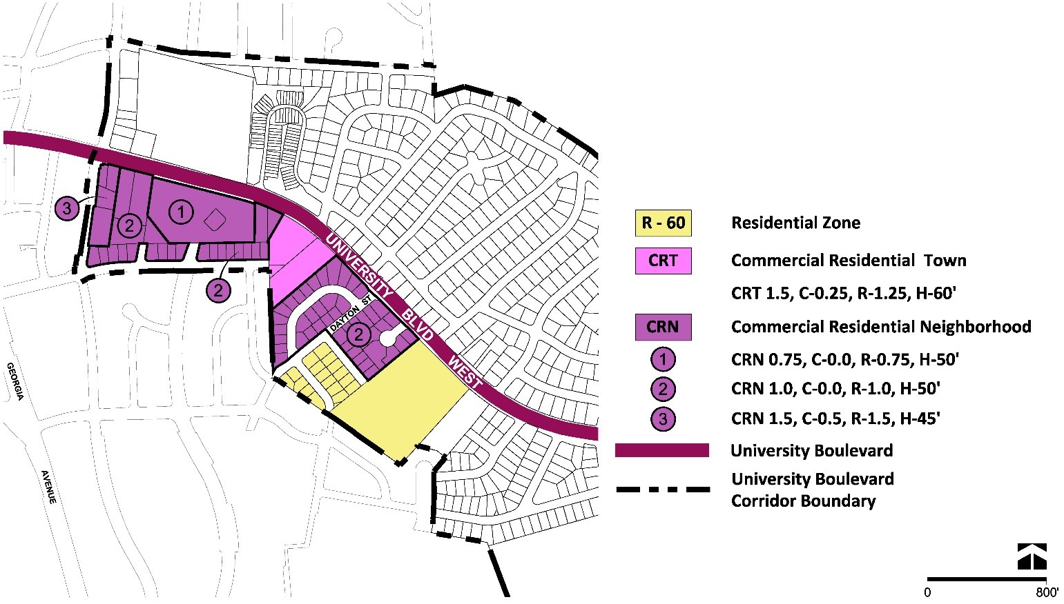
- Confirm the CR-2.0 C-1.5 R-1.5 H-75 Zone for the retail property at 2119 University Boulevard West and all other properties, including the U.S. Postal Service property, along Amherst Avenue, as shown in Figure 13.
- Rezone the WTOP Transmitter property from the R-90 Zone to the CRT 1.5 C-0.5 R-1.25 H-70 Zone to promote infill mixed-use development in proximity to existing and planned transit that contributes to the Plan’s public benefits, as shown in Figure 14.
- Rezone the Berkeley Court/Westchester development from the PD-9 Zone to the CRN 1.0 C-0.0 R-1.0 H-50 Zone as a suitable equivalent zone for the property, since the PD Zone cannot be confirmed through the Sectional Map Amendment (SMA).
- Rezone the detached residential properties as shown in Figures 13 and 14.
Urban Design Recommendations
Redevelopment of this area should explore:
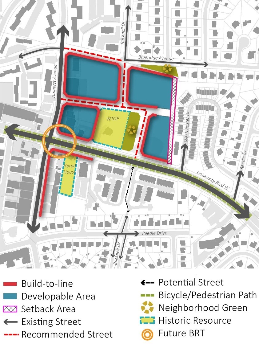
- Opportunities for coordinated redevelopment of the WTOP property and properties fronting on Amherst Avenue, as shown in Figure 15.
- Integration of recommended BRT station into redevelopment.
- Higher densities and activated building frontages along University Boulevard West and Amherst Avenue that include a mix of uses and active fronts to support recommended transit.
- Activated privately owned public space.
- An internal street grid that connects to surrounding existing public streets.
- A variety of residential unit types including multifamily, medium- and small-scale developments.
- Consolidated parking solutions accessible from internal streets that minimize or eliminate curb cuts along Amherst Avenue and University Boulevard West.
Future development of the WTOP property must:
- Protect and preserve the WTOP Transmitter (M: 31-12) listed in the Master Plan for Historic Preservation.
- New development adjacent to the WTOP Transmitter should enhance its environmental setting by exploring architectural elements and building heights that are compatible with the historic resource’s scale and architectural style, and that maintain its visibility and prominence on the property.
- Complete archaeological investigations consistent with §18-31 of the County Code.
- Create a new street network on the property that provides pedestrian, bicycle, and vehicular connections to Blueridge Avenue and University Boulevard West.
- If development is coordinated with properties fronting on Amherst Avenue, provide a street connection to Amherst Avenue between University Boulevard and Blueridge Avenue; if a street connection is not feasible, at a minimum, provide a pedestrian and bicycle connection.
- Activate Blueridge Avenue with lower density development to transition to the existing residential community and improve the pedestrian connections between Amherst Avenue and Blueridge Avenue.
- Explore alternatives for outdoor activity at different scales throughout the development, including pocket greens, a farmers’ market, and shared streets.
Hearthstone Village Neighborhood
Land Use and Zoning Recommendations
- Confirm the CRN 1.5 C-0.5 R-1.5 H-45 Zone for the non-residential properties along Amherst Avenue, as shown in Figure 17.
- Designate the Romeo and Elsie Horad House (M: 31-87) in the Master Plan for Historic Preservation and encourage the adaptive reuse of the building.
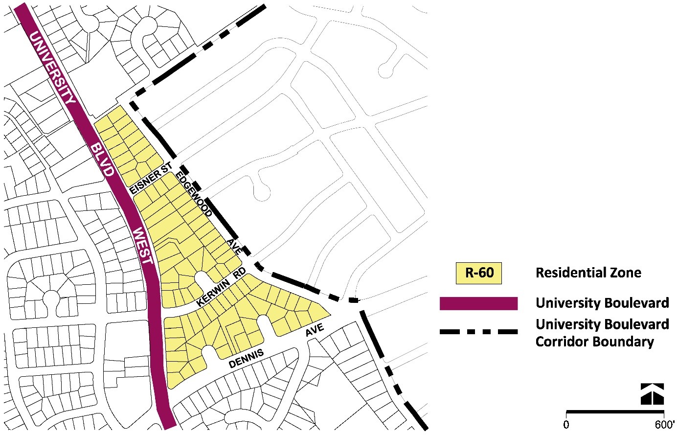
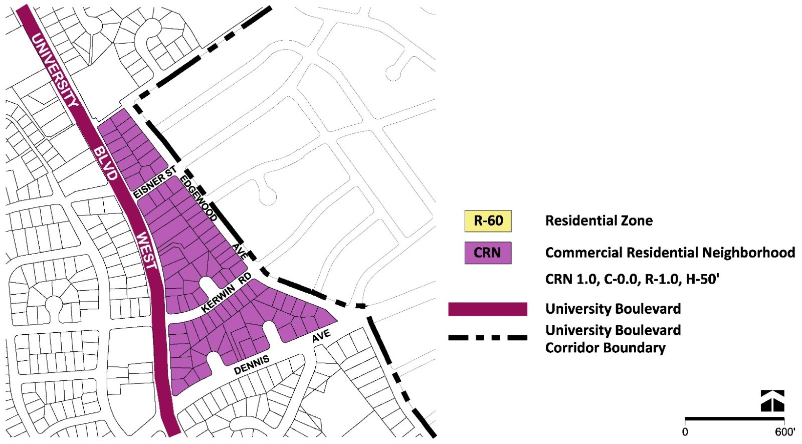
- Rezone the Canaan Christian Church properties at 2100 and 2118 University Boulevard West and 11221 Rose Lane and the vacant property at 11220 Rose Lane from the R-60 Zone to the CRN 1.0 C-0.0 R-1.0 H-50 Zone, as shown in Figure 18, to support new infill development and advancing the Plan’s recommended public benefits, including historic resource preservation.
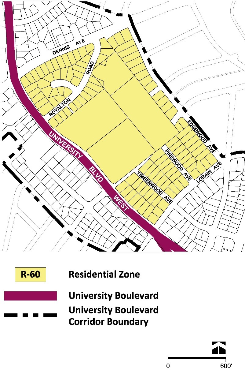
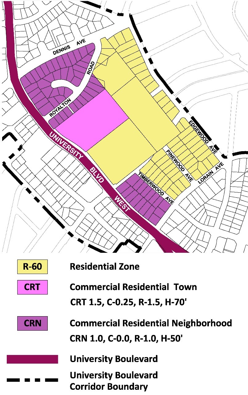
- Rezone the Hearthstone residential community from the PD-18 Zone to the CRN 0.75 C-0.0 R-0.75 H-50 Zone as a suitable equivalent zone for the property since the PD Zone cannot be confirmed through the Sectional Map Amendment.
- Rezone the Har Tzeon property from the R-60 Zone to the CRT 1.5 C-0.25 R-1. 25 H-60 Zone to support the Plan’s recommendations to encourage new residential development at institutional properties.
- Rezone the detached residential properties as shown in Figures 17 and 18.
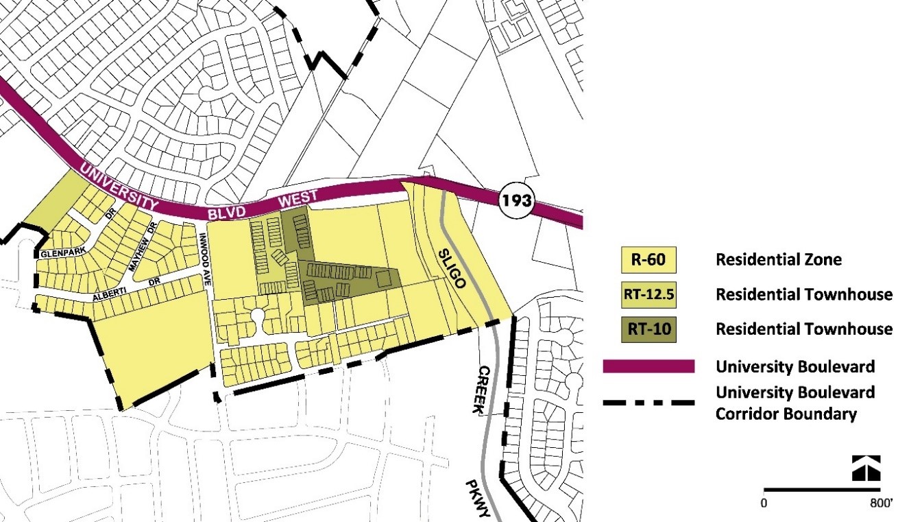
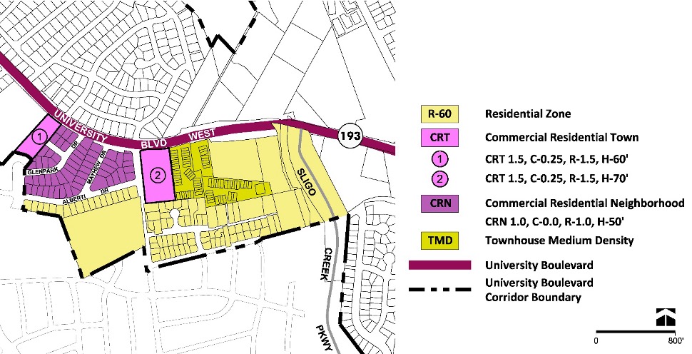
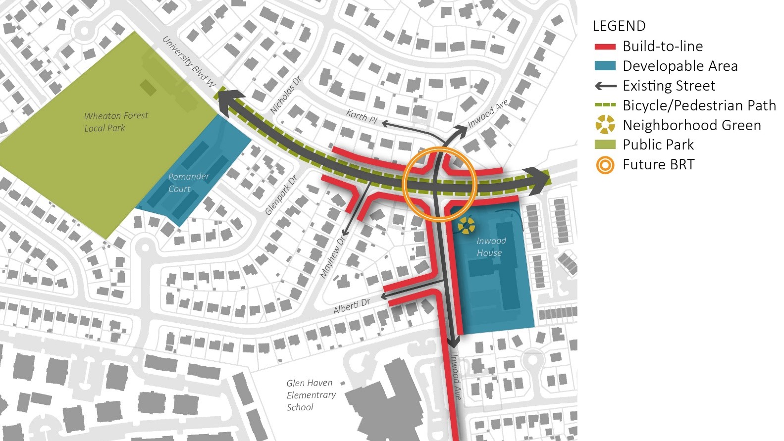
Inwood House Neighborhood
Land Use and Zoning Recommendations
- Rezone the Pomander Court property from the Residential Town (RT-12.5) Zone to the CRT 1.5 C-0.25 R-1.5 H-60 Zone, as shown in Figures 20 and 21, to support the Plan’s recommended public benefits.
- Rezone the Surrey Walk and Wetherstone residential townhouse communities from the RT-10 and RT-12.5 Zones to the Townhouse Medium Density (TMD) Zone as the RT-10 and RT-12.5 Zones cannot be confirmed through the Sectional Map Amendment.
- Rezone the Inwood House property at 10921 Inwood Avenue from the R-60 Zone to the CRT 1.5 C-0.25 R-1.5 H-70 Zone to support infill or redevelopment of the property that further the Plan’s public benefits, including affordable housing and specialized housing for residents with disabilities.
- Rezone the detached residential properties as shown in Figures 20 and 21.
Urban Design Recommendations
Properties around the intersection of Inwood Avenue and University Boulevard West have development potential that could anchor the recommended BRT station with mixed-use development or higher-density residential uses. Redevelopment around this intersection should adhere to these concepts, as shown in Figure 22:
- Mixed-use redevelopment of the Inwood House property that integrates the proposed BRT station and includes affordable housing, particularly for residents with disabilities, as well as public open space and neighborhood serving retail to promote pedestrian activity and support transit users.
- Corridor-fronting small and medium-scale multifamily development at the other three quadrants of this intersection, to connect residents with recommended pedestrian, bicycle, and transit improvements along the corridor.
- Redevelopment of the Pomander Court property with higher-density residential uses, frontage improvements along University Boulevard West, and pedestrian and bicycle connections to Wheaton Forest Local Park.
- Promote the Safe Routes to School initiative developed by Montgomery County Public Schools (MCPS) by modifying the intersection of University Boulevard West and Inwood Avenue to include a dedicated signalized left turn.
- Promote a more compact and street-oriented Glen Haven Elementary School that minimizes surface parking along Inwood Avenue.
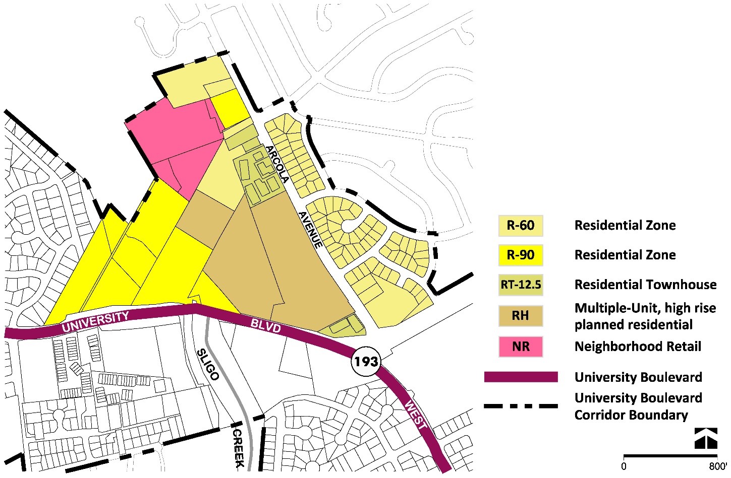
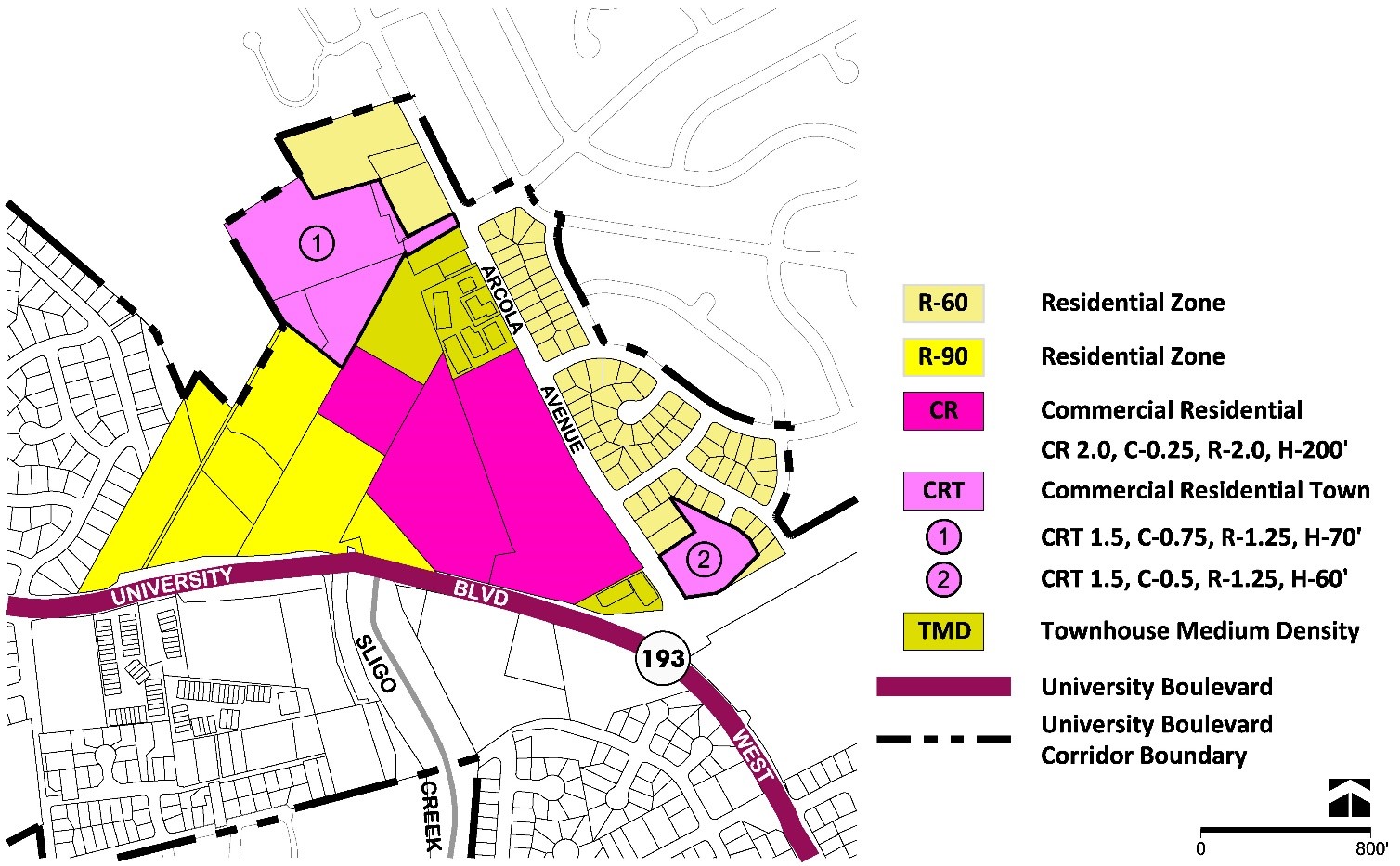
Arcola Avenue District
The Arcola Avenue District is bordered by Sligo Creek Stream Valley Park to the west and Orange Drive to the east and includes the neighborhoods of University Towers, Breewood Park, and Northwood.
Arcola Avenue District
University Towers Neighborhood
Land Use and Zoning Recommendations
- Rezone the University Towers, Warwick Apartments, and Arcola Towers properties from the RH Zone to the CR 2.0 C-0.25 R-2.0 H-200 Zone, as shown in Figures 25 and 26, to permit conforming properties and the opportunity for infill development that contributes to the Plan’s recommended public benefits.
- Rezone the residential townhouses at Northwoods Crossing (11000–11026 Hemingway Court) and the Stonington Woods communities from the RT-12.5 Zone to the TMD Zone, as the RT-12.5 Zone cannot be confirmed through the Sectional Map Amendment.
- Rezone the Young Israel Shomrai properties at 1128 Arcola Avenue and 1132 Arcola Avenue, and the Parkland Swim Club property at 1124 Arcola Avenue, from the RT-12.5 Zone and R-60 Zone to the TMD Zone to permit development flexibility between property owners.
- Rezone the Kemp Mill Shopping Center properties, including 1370 Lamberton Drive and 1398 Lamberton Drive, from the Neighborhood Retail (NR) Zone to the CRT 1.5 C-0.75 R-1.25 H-70 Zone to promote the Plan’s recommended public benefits.
- Rezone the Montgomery Parks properties (1206 Arcola Avenue and Parcel Tax ID 03358966) from the R-90 Zone to the CRT 1.5 C-0.75 R-1.25 H-70 Zone to support any potential development with the adjacent commercial property. Should redevelopment of the adjacent commercial property occur, the property owners should explore opportunities to exchange these properties for property of an equal or greater size (approximately 20,000 square feet) to augment the functionality of Kemp Mill Urban Park.
- Rezone the Autumn Lake Healthcare at Arcola property at 901 Arcola Avenue from the R-60 Zone to the CRT 1.5 C-0.5 R-1.25 H-60 Zone.
- Confirm the R-60 Zone for the Yeshiva of Greater Washington property at 1216 Arcola Avenue and the R-90 Zone for the Kemp Mill Urban Park.
- Confirm the detached residential properties, east of Arcola Avenue and within the Plan area, to the R-60 Zone.
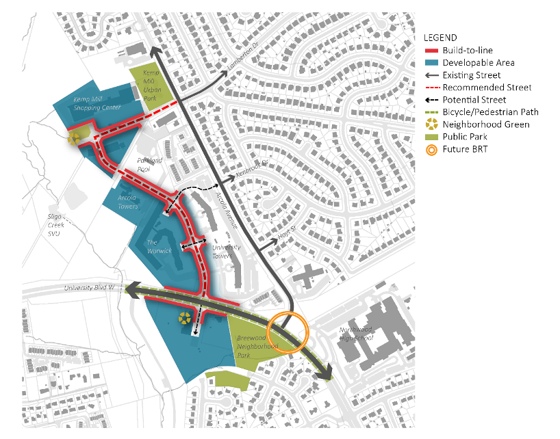
Urban Design Recommendations
Properties around the planned BRT station at Arcola Avenue and University Boulevard West offer limited opportunities for redevelopment.
The cluster of properties around and including Kemp Mill Shopping Center have potential for coordinated development to create a new mixed-use neighborhood center. Redevelopment at the shopping center and other properties should consider the following, as shown in Figure 27:
- Establish a compact development pattern of short blocks and internal streets with an enhanced streetscape to promote pedestrian activity between the surrounding community and the new center.
- Explore a mix of uses that includes retail and a broad range of residential unit types, including attached and multifamily development, to serve different needs and income levels.
- Improve and extend the existing access road from University Boulevard West through University Towers as a pedestrian-friendly street with street-facing buildings and an enhanced streetscape that connects with new internal streets in the redeveloped shopping center cluster, to provide an alternative vehicular connection north and east of Arcola Avenue.
- If Kemp Mill Shopping Center redevelops, provide a minimum 0.75-acre privately owned public space, consistent with a neighborhood green on larger shopping center parcels, near the Sligo Creek Trail entrance. Explore placemaking opportunities on the shopping center property to incorporate public art and wayfinding, and to consider activation strategies for the recommended neighborhood green.
Breewood Park Neighborhood
Land Use and Zoning Recommendations
- Rezone the Northwood Presbyterian Church properties at 1200 University Boulevard West and the property at 1106 University Boulevard West from the R-60 Zone to the CRT 1.5 C-0.25 R-1.5 H-70 Zone, as shown in Figures 29 and 30, to promote new infill development and to further the Plan’s public benefits.
- Explore mechanisms to transfer the right-of-way at the termini of Breewood Road and Tenbrook Drive to M-NCPPC to improve the Northwood Chesapeake Bay Trail alignment and solidify maintenance and management of the trail by Montgomery Parks between Sligo Creek Stream Valley Park and Breewood Neighborhood Park.
- Rezone the Good Shepherd Episcopal Church at 818 University Boulevard West from the R-60 Zone to the CRT 1.5 C-0.25 R-1.5 H-60 Zone to support the Plan’s recommendations to promote infill development on institutional properties.
- Rezone the detached residential properties as shown in Figures 29 and 30.
Urban Design Recommendations
The properties at 1200 and 1106 University Boulevard West, including Northwood Presbyterian Church, have the potential for significant redevelopment that would enhance the vicinity of the planned BRT station at Arcola Avenue. Corridor-fronting residential properties east of Breewood Neighborhood Park also have potential for adding residential units that can support transit ridership at this location. Redevelopment at these locations should:
- Explore mixed-use development at 1200 and 1106 University Boulevard West that creates active frontages along University Boulevard, extends connectivity north through the Access Road along University Towers, and provides a mix of uses, including residential and public open space.
- Improve natural surface trail connections between the Northwood Chesapeake Bay Trail and the termini of Tenbrook Drive and Breewood Road to ensure that the trail connections are signed, marked, and mapped.
- Establish a public paved surface trail or similar connection between University Boulevard West and the paved Sligo Creek Trail through the Northwood Presbyterian Church property, with redevelopment.
- Promote small-scale multifamily development at corridor-fronting residential properties.
Northwood Neighborhood
Land Use and Zoning Recommendations
- Confirm the R-60 Zone for Northwood High School and Forest Knolls Elementary School.
- Rezone Luther Rice Memorial Baptist Church at 801 University Boulevard West from the R-60 Zone to the CRT 1.5 C-0.25 R-1.5 H-60 Zone to promote new infill development and to further the Plan’s public benefits.
- Rezone Young Israel Shomrai Emunah at 811 and 813 University Boulevard West, as well as the detached residential properties as shown in Figures 32 and 33.
Dennis Avenue District
The Dennis Avenue District extends from Orange Drive and Hannes Street to the west and Lorain Avenue to the east and includes the neighborhoods of Sligo Woods, Mary’s Center, Northwood Park, and North Four Corners.
Dennis Avenue District
Sligo Woods Neighborhood
Land Use and Zoning Recommendations
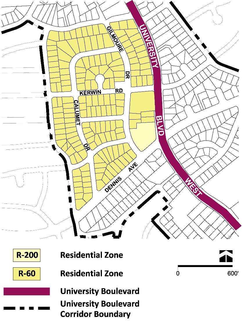
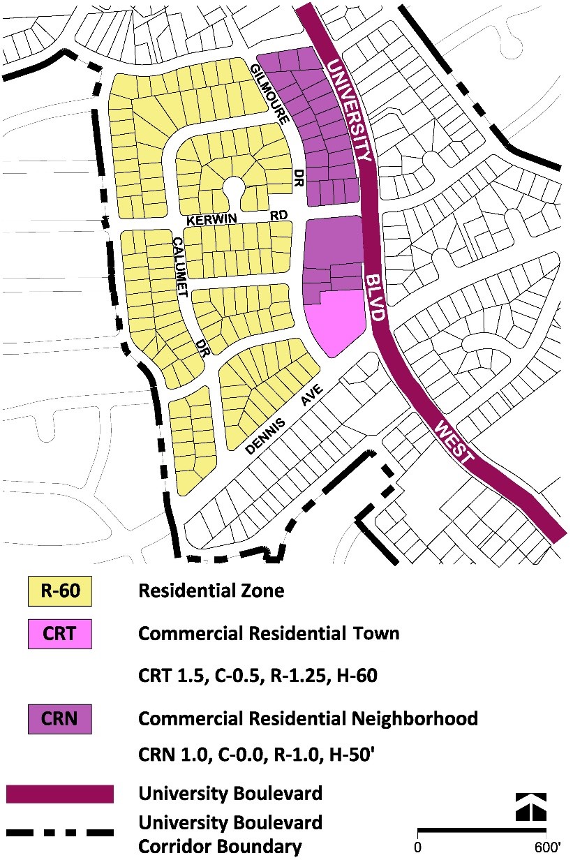
- Rezone the Collins Funeral Home property at 500 University Boulevard West from the R-200 Zone to the CRT 1.5 C-0.5 R-1.25 H-60 Zone.
- Rezone the Verizon substation and four detached residential properties, 10311–10317 Gilmoure Drive, from the R-60 Zone to the CRN 1.0 C-0.0 R-1.0 H-50 Zone to promote redevelopment near planned BRT.
- Rezone the detached residential properties as shown in Figures 35 and 36.
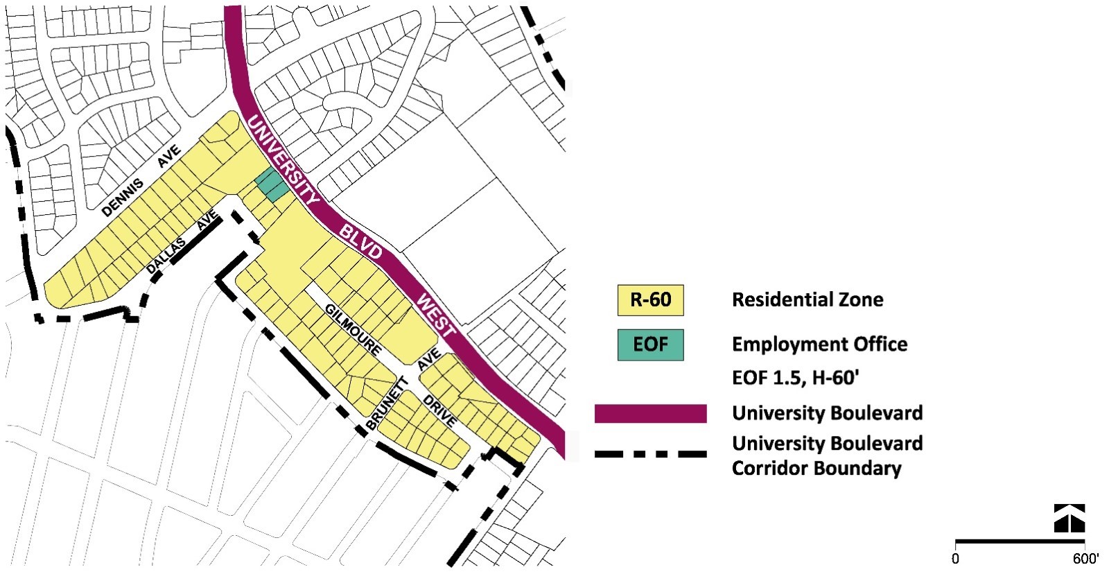
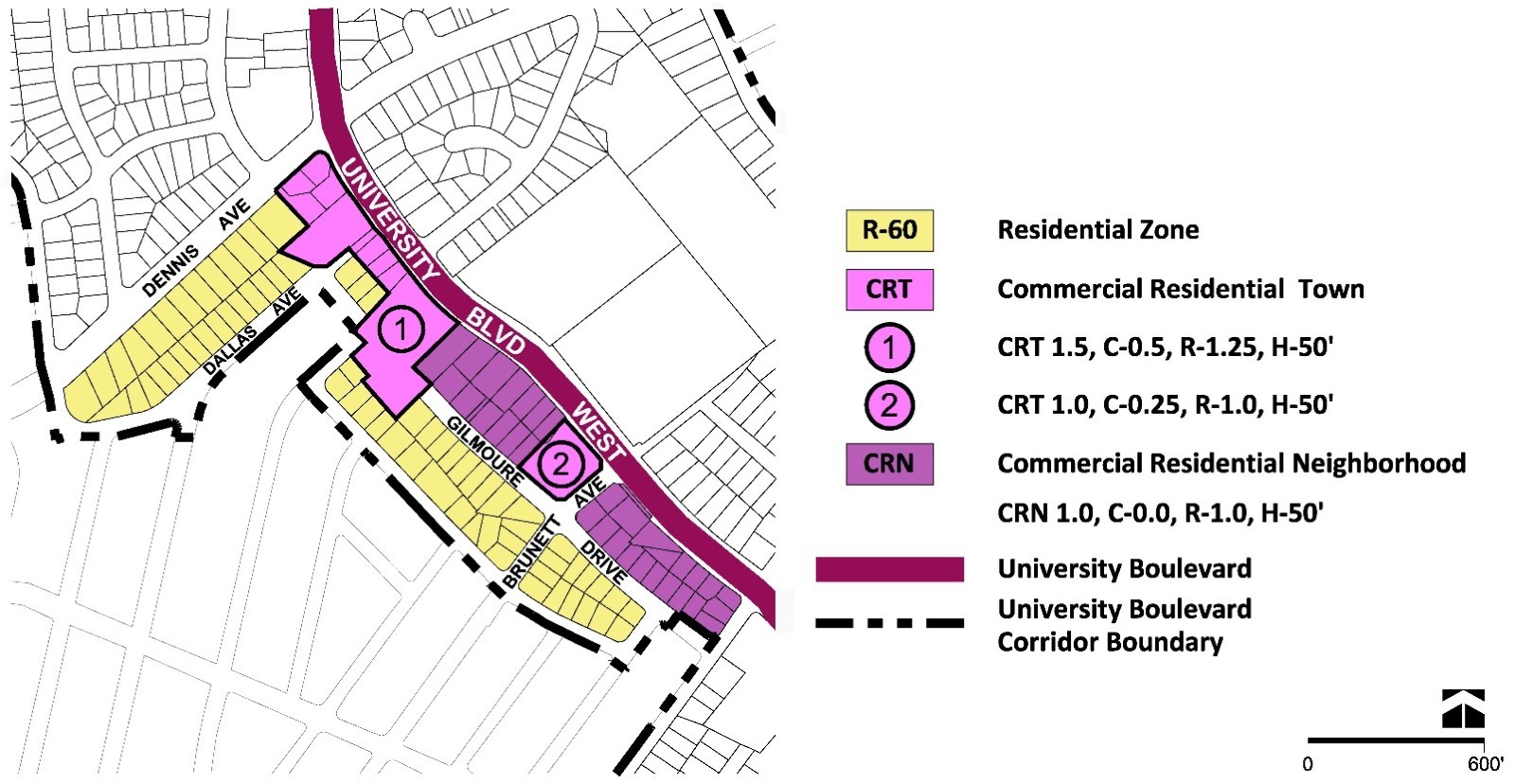
Mary’s Center Neighborhood
Land Use and Zoning Recommendations
- This Plan recommends a consistent land use approach, via the CRT Zone, for existing residential and non-residential properties that would permit new infill development near the planned BRT station at Dennis Avenue, as shown in Figures 38 and 39.
- Three vacant parcels and a detached dwelling at the southwest intersection of University Boulevard and Dennis Avenue are under common ownership and offer an opportunity to redevelop with primarily residential uses, including attached and multifamily development. New residential development at this location will serve as a gateway feature to this area.
- Mary’s Center provides county residents with healthcare, education, and social services. This Plan supports the CRT Zone for the property since it permits the existing use and provides more flexibility if the property is redeveloped in the future. If the property completely redevelops, this Plan supports a new pedestrian or bikeway extension of Greenock Road to University Boulevard or the extension of Gilmoure Drive.
- The Nichiren Shoshu Myosenji Buddhist Temple, located at Brunett Avenue and University Boulevard, is a religious institutional property. This Plan supports the future evaluation of the Temple for listing as a Master Plan Historic Site, with the potential for adaptive reuse. If the Temple were removed, appropriate redevelopment for the site includes attached units such as duplexes or townhouses.
NORTHWOOD PARK NEIGHBORHOOD
- Rezone the detached residential properties from the R-60 Zone to the CRN 1.0 C-0.0 R-1.0 H-50 Zone, as shown in Figures 41 and 42.
North Four Corners Neighborhood
Land Use and Zoning Recommendations
- Rezone the HOC property from the R-60 Zone to the CRT 1.5 C-0.25 R-1.5 H-70 Zone, as shown in Figures 44 and 45, to further the Plan’s recommended public benefits, including affordable housing and public open space.
- Redevelopment on the HOC property must provide a financial contribution for park improvements in or near the Plan area at the time of redevelopment, in lieu of on-site open space. In addition to the contribution, redevelopment should improve connections to and engage North Four Corners Local Park.
- Rezone the detached residential properties as shown in Figures 44 and 45.
Four Corners District
The Four Corners District extends between Lorain Avenue and the Capital Beltway (I-495) and includes the neighborhoods of Four Corners West and Four Corners North, as well as Woodmoor Shopping Center and Montgomery Blair High School.
Four Corners District
Four Corners West Neighborhood
Land Use and Zoning Recommendations
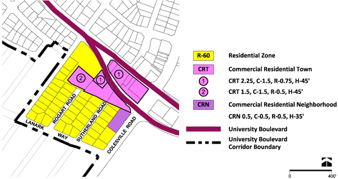
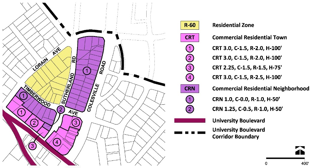
- Rezone the commercial properties (2 University Boulevard West, 22 University Boulevard West, 106 University Boulevard West, 108 University Boulevard West, and 10040 Colesville Road) in the median of University Boulevard West from the CRT-2.25 C-1.5 R-0.75 H-45 Zone to the CRT 2.5 C-1.5 R-1.5 H-75 Zone to promote the Plan’s recommended public benefits, as shown in Figures 48 and 49.
- Rezone the Safeway Shopping Center property at 116 University Boulevard West from the R-60 Zone and the CRT 1.5 C-1.5 R-0.5 H-45 Zone to the CRT 3.0 C-1.5 R-2.5 H-100 Zone to promote mixed-use development that contributes to the recommended public benefits.
- Rezone the U.S. Postal Service property at 110 University Boulevard West from the CRT 1.5 C-1.5 R-0.5 H-45 Zone to the CRT 2.25 C-1.5 R-1.5 H-75 Zone that promotes the Plan’s recommended public benefits.
- Rezone the Four Corners Office Park property from the R-60 Zone and the CRN 0.5 C-0.5 R-0.25 H-35 Zone to the CRN 0.5 C-0.5 R-0.5 H-40 Zone to remove split zoning of the property.
- Rezone the property at 10000 Colesville Road from the R-60 Zone to the CRN 0.5 C-0.5 R-0.5 H-40 Zone.
- Rezone the BP automotive service center property at 112 University Boulevard West from the CRT 2.25 C-1.5 R-0.75 H-45 Zone to the CRT 2.25 C-1.5 R-1.5 H-75 Zone to support the recommended public benefits.
- Rezone the Shell gas station property at 100 University Boulevard West from the CRT 1.5 C-1.5 R-0.5 H-45 Zone to the CRT 2.25 C-1.5 R-1.5 H-75 Zone to support the Plan’s recommended public benefits.
- Rezone the detached residential properties as shown in Figures 48 and 49.
Urban Design Recommendations
- Encourage property assembly of the single-use commercial properties in this neighborhood to create a consistent block pattern that facilitates a new street network or linear open space that promote new development opportunities.
- Concentrate taller buildings toward University Boulevard and lower building heights toward existing detached residential properties.
- Locate structured parking either above or below grade, to minimize street exposure.
- With future redevelopment of the Safeway grocery store, provide a minimum 0.25-acre privately owned public space, consistent with the characteristics of a neighborhood green.
- If properties are redeveloped individually, the following design parameters must be considered:
- Ensure consistent building frontages for new development.
- Incorporate a visual landmark or public art that contributes to creating a sense of place.
- Redevelopment should incorporate frontage zone improvements, such as building entrances, street furniture, sidewalk cafés, retail displays, landscaping, or other items— as determined through the regulatory review process—on property outside the public right-of-way along the southern edge of eastbound University Boulevard.
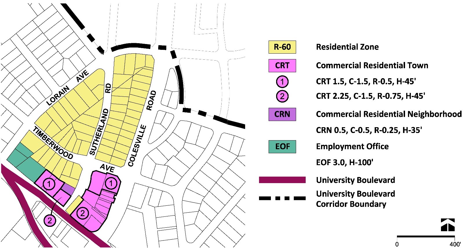
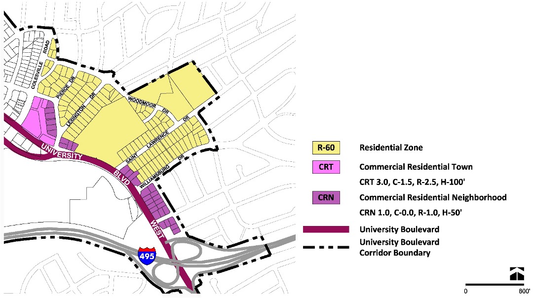
Four Corners North Neighborhood
Land Use and Zoning Recommendations
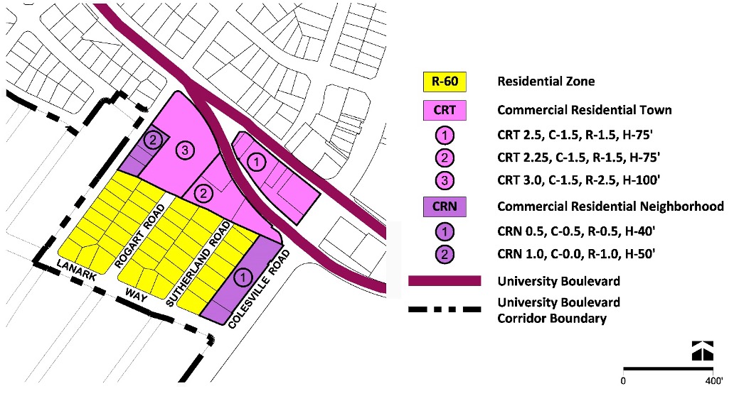
- Rezone the commercial properties in the northeast intersection of Colesville Road and University Boulevard West, as shown in Figure 52, including at 10100 Colesville Road, 10110 Colesville Road, 10118 Colesville Road, 10120Colesville Road, 10126 Colesville Road, 10130 Colesville Road, 10132 Colesville Road, 10134 Colesville Road, Parcel 072 and Parcel P11 from the R-60 Zone and the CRT 2.25 C-1.5 R-0.75 H-45 Zone to the CRT 3.0 C-1.5 R-2.5 H-100 Zone to promote mixed-use development that support the Plan’s public benefits, mobility options, and pedestrian connections.
- Rezone the properties at 10144 Colesville Road and 110 Sutherland Road from the CRT 1.5 C-1.5 R-0.5 H-45 Zone to the CRT 2.25 C-1.5 R-1.5 H-75 Zone to support mixed-use development that is in proximity to BRT stations.
- Rezone the commercial property at 101 University Boulevard West from the CRT 2.25 C-1.5 R-0.75 H-45 Zone to the CRT 2.25 C-1.5 R-1.5 H-75 Zone to support the recommended public benefits.
- Rezone the commercial properties at 105-111 University Boulevard West from the CRT 1.5 C-1.5 R-0.5 H-45 Zone to the CRT 3.0 C-1.5 R-2.0 H-100 Zone to support new mixed-use development and the Plan’s public benefits.
- Rezone the commercial properties at 115 University Boulevard West, 10101 Lorain Avenue and 10105 Lorain Avenue from the EOF 3.0 H-100 Zone to the CRT 3.0 C-1.5 R-2.0 H-100 Zone to support the Plan’s public benefits, including housing and mobility options.
- Rezone the detached residential properties as shown in Figures 51 and 52 to support the Plan’s recommendations for new residential typologies.
Urban Design Recommendations
- Focus redevelopment along University Boulevard West (MD 193) and Colesville Road (U.S. 29) to enhance the BRT stations, as shown in Figure 53.
- Explore a pedestrian connection between Colesville Road and Sutherland Road, east of University Boulevard West.
- Concentrate maximum development intensity along University Boulevard and ensure that building heights transition to residential properties along Timberwood Avenue.
- Explore a mid-block pedestrian connection or linear open space from Colesville Road to Sutherland Road between University Boulevard West and Timberwood Avenue, to expand pedestrian activity and improve alternative access to BRT.
- Redevelopment should consolidate or relocate driveways along University Boulevard West to improve the public realm for those walking, biking and rolling and to facilitate access for transit users.
- Redevelopment should incorporate frontage zone improvements, such as building entrances, street furniture, sidewalk cafés, retail displays, landscaping, or other items— as determined through the regulatory review process—on property outside the public right-of-way along the northern edge of westbound University Boulevard.
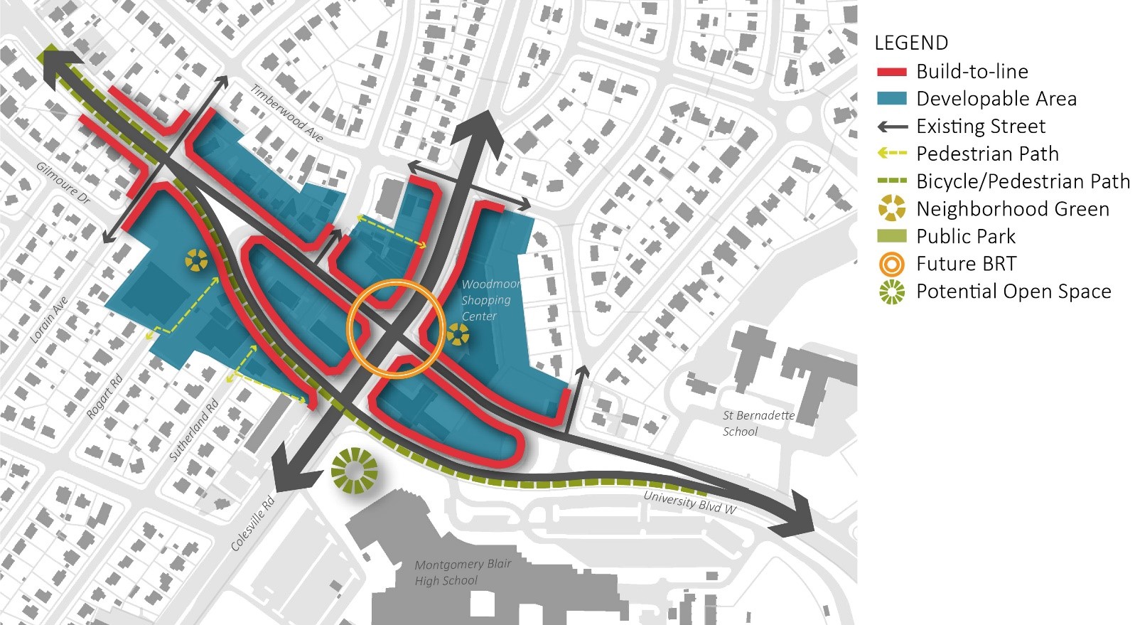
Woodmoor Shopping Center Neighborhood
Land Use and Zoning Recommendations
- Rezone the Woodmoor Shopping Center, as shown in Figures 55 and 56, from the CRT 0.75 C-0.75 R-0.5 H-40 Zone to the CRT 3.0 C-1.5 R-2.5 H-100 Zone to promote mixed-use development in the Four Corners area that supports the Plan’s recommended public benefits.
- Rezone detached residential properties as shown in Figures 55 and 56 to support the Plan’s recommended new residential typologies.
Urban Design Recommendations
- If the shopping center is redeveloped, the front and central portion of the property must include higher densities and taller buildings. The existing rear surface parking area should be developed with lower building heights that transition to the residential properties on Pierce Drive.
- Establish building frontages along Colesville Road and University Boulevard East to define the public realm with active uses and streetscape improvements.
- Explore structured parking solutions integrated into new development that consolidate parking away from public view.
- With redevelopment, provide a minimum 0.25-acre privately owned public space consistent with a neighborhood green on the property.
- Alternatively, redevelopment could explore integrating the existing structure into a mixed-use development that includes consolidated parking in the rear along with residential uses, and public open space in the existing front surface parking lot.
- If the shopping center does not redevelop, the property owner should incorporate various environmental measures to mitigate heat, including but not limited to, new landscaping or rain gardens in surface parking areas.
Montgomery Blair High School
Land Use and Zoning Recommendations
- Confirm the R-60 Zone for Montgomery Blair High School, Blair Local Park, and Silver Spring Fire Station No.16, as shown in Figures 58 and 59.
- Rezone the Four Corners Ethiopian Evangelical Church property from the R-60 Zone and the CRT C-0.25 C-0.25 R-0.25 H-35 Zone to the CRT 3.0 C-1.5 R-2.5 H-100 Zone to promote infill development and the Plan’s recommended public benefits.
Urban Design Recommendations: Four Corners Ethiopian Evangelical Church property
- Redevelopment at this location should take advantage of its unique visibility to explore creative building form and signature architectural features.
- New development should improve pedestrian circulation and access, with enhanced streetscape and safe crossings to properties to the north (Woodmoor Shopping Center) and south (Blair High School).
- With redevelopment, provide a minimum 0.25-acre privately owned public space consistent with a neighborhood green or urban plaza.
Urban Design Recommendations: Blair High School
- Explore a placemaking strategy to improve existing green area at the intersection of University Boulevard and Colesville Road and create usable public open space at the intersection of Colesville Road and University Boulevard.
- Colocate community services and amenities at the school, consistent with the county’s policy regarding ongoing co-location of public facilities.
Housing
Housing Recommendations
Parks, Trails, and Open Space
Public Parks Recommendations
Public Parks Recommendations
This Plan does not recommend any new public parks. While this Plan area is generally well served by parks and trails, there are opportunities to enhance existing parks, including providing new access points and new facilities or amenities that are needed in this area of the county. The following recommendations are for existing M-NCPPC parks in the Plan area, which will enhance, expand, or otherwise improve these parks.
Wheaton Forest Local Park
- Improve pedestrian connections from the adjacent Pomander Court property when it redevelops.
- Consistent with recommendations elsewhere in the county, when properties adjacent to parks redevelop, in lieu of on-site open space require a financial contribution from this property owner for park improvements in or near the Plan area at the time of development.
- Redevelopment of adjacent properties should relate to and engage the park and ensure that park edges are attractive. For example, do not locate parking lots or dumpsters immediately adjacent to the park.
- Investigate options and opportunities to create more shade for park users and especially for athletic field spectators.
- Consolidate the two entrances to the parking lot into a single entrance in accordance with other recommendations and goals of the Plan related to increased pedestrian safety and comfort along University Boulevard.
- Create a paved trail loop in the park that goes around the athletic fields and creates a clearer pedestrian and bicycle connection through the park from the residential neighborhoods to the south to University Boulevard.
Sligo Creek Stream Valley Park
- When the Northwood Presbyterian Church property redevelops, improve public bicycle and pedestrian access and connection between University Boulevard and the Sligo Creek Trail.
- The Northwood Chesapeake Bay Trail passes through the Sligo Creek Stream Valley Park and Breewood Neighborhood Park, as well as unimproved portions of right-of-way for Breewood Road and Tenbrook Drive, to connect Sligo Creek Trail to University Boulevard. This Plan recommends that management of the unimproved portions of the right-of-way be transferred to Montgomery Parks by the appropriate mechanism to consolidate management and maintenance of the trail by Montgomery Parks and ensure permanent protection of the property and trail route as parkland.
- Relocate the playground between Sligo Creek Parkway and Sligo Creek just south of University Boulevard out of the floodplain.
- Continue to treat and improve stormwater discharge from non-parkland sources into Sligo Creek and its tributaries.
- Improve fish passage in Sligo Creek by reconnecting the stream under University Boulevard.
- Improve the Sligo Creek Trail entrance at Kemp Mill Shopping Center. Redevelopment of the adjacent Kemp Mill Shopping Center property should provide improvements at this location, including improvements that meaningfully connect the privately owned public space, Kemp Mill Urban Park, and Sligo Creek Trail through new street and trail connections, placemaking, and wayfinding.
- Create a paved trail connection for people walking, biking, and rolling between Wheaton Lane and the Sligo Creek Trail.
MDOT SHA Land and The Northwood Chesapeake Bay Trail
- The Northwood Chesapeake Bay Trail passes through a strip of land owned by MDOT SHA adjacent to the north side of Northwood High School (Parcel Tax ID 980570). This Plan recommends that this property and the adjoining MDOT SHA property that contains the trail and extends beyond the Plan area (Parcel Tax ID 980626) be conveyed by MDOT SHA to M-NCPPC as soon as possible to consolidate management and maintenance of the trail by Montgomery Parks and ensure permanent protection of the property and trail route as parkland.
Kemp Mill Urban Park
- M-NCPPC owns the property containing the driveway entrance to the adjacent Kemp Mill Shopping Center. If the shopping center property is redeveloped, the property owners should explore opportunities to exchange the M-NCPPC–owned properties for property of an equal or greater size (approximately 20,000 square feet), while maintaining access to the shopping center site, to augment the functionality of Kemp Mill Urban Park.
- If the shopping center redevelops, create a new street with pedestrian and bicycle facilities to provide a connection between the park and the Sligo Creek Trail.
North Four Corners Local Park
- Improve pedestrian connection from the adjacent HOC property when it redevelops. If the redevelopment provides an upgraded, publicly accessible connection on-site, it may be factored into the financial contribution for parks.
- Consistent with recommendations for redevelopment of properties adjacent to parks elsewhere in the county and Section 59-6.3.6.C of the Zoning Ordinance, require a financial contribution from this property owner for park improvements in or near the Plan area instead of requiring open space on-site at the time of redevelopment. If the project provides 25% or more MPDUs that receive either an exemption or discount from development impact taxes, the contribution may be reduced proportionally.
- Redevelopment of adjacent properties should relate to and engage the park and ensure that park edges are attractive. For example, do not locate parking lots or dumpsters immediately adjacent to the park.
- Investigate options and opportunities to create more shade for park users and especially for athletic field spectators.
- Engage residents and community stakeholders to identify an appropriate long-term lease for the currently vacant park activity building, one that complements the park and addresses community needs and interests.
Pinecrest Local Park
- Add interpretive signs to educate visitors about the historic Pinecrest Recreation Center.
New Open Spaces
- This Plan recommends new publicly accessible open spaces on key properties, such as WTOP and Safeway, which may redevelop in the future. These new privately–owned, public spaces will contribute to creating a livable environment and complete communities associated with new development.
Environmental Sustainability
Environmental Recommendations
Transportation
Street Network Recommendations
Street Network Recommendations
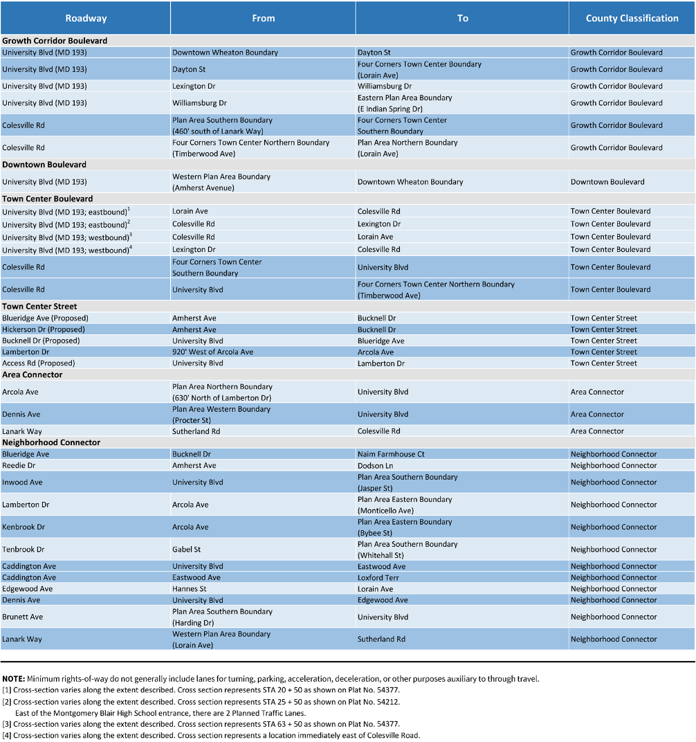
- Implement a connected network of streets along University Boulevard with redevelopment, as shown in Figure 73. Development should prioritize traffic calming as part of redevelopment to consider the context of neighborhood streets.
- Realign existing streets across University Boulevard to support intersection signalization, manage vehicular access, smooth vehicular traffic progression, and reduce the spacing between protected pedestrian crossings. Priority locations for future realignment include Markwood Drive / Dayton Street; Nicholas Drive / Pomander Court / Glenpark Drive; and Eisner Street / Orange Drive.
- Connect streets to University Boulevard to manage vehicular access and improve local multimodal circulation. Priority locations include Tenbrook Drive / Access Road; Orange Drive; and Greenock Road / Royalton Road.
- Connect parallel streets along the south/west side of University Boulevard to provide a more direct travel route for people walking and biking and to provide site access and local circulation for properties along University Boulevard in the event of their redevelopment. Priority locations include Breewood Road / Whitehall Street; Whitehall Street / Gilmoure Drive; Gilmoure Drive between Dennis Avenue and Dallas Avenue; and Gilmoure Drive between Dallas Avenue and Brunett Avenue.
- Potential traffic calming as part of redevelopment could include:
- Installing new sidewalks or sidepaths and street buffers consistent with Complete Streets Design Guide Neighborhood Yield Street, Neighborhood Street, Neighborhood Connector, or Area Connector guidance, as appropriate.
- Striping on-street parking to visually narrow the vehicle travel lanes and reduce vehicle travel speeds even when on-street parking spaces are not occupied.
- Alternating the side of the street with on-street parking in locations with enough width for on-street parking on only one side of the street to shift traffic horizontally and reduce vehicle travel speeds.
- Installing curb extensions at the ends of striped on-street parking bays and in locations without on-street parking to narrow vehicle travel lane widths to the minimum consistent with the Complete Streets Design Guide.
- Reducing curb radii to the minimum consistent with the Complete Streets Design Guide to reduce the speed of turning vehicles.
Installing speed humps, speed tables, or other traffic calming measures.
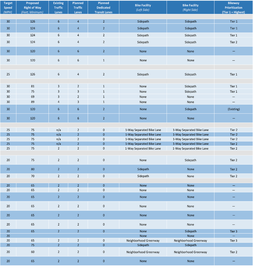
- Right-size roadways and intersections to create a safer and more comfortable environment for people who are walking, rolling, bicycling, riding transit, and driving, as shown in Table 1.
- Repurpose general-purpose travel lanes to provide dedicated transit lanes and improved facilities for people walking, biking, and rolling that are separated from vehicular traffic by street trees and planted green space.
- Make travel lanes narrower and reduce roadway design speeds to targets identified in the Complete Streets Design Guide.
- Remove channelized right-turn lanes from all intersections, unless the Director of Transportation or the Director’s designee determines that removing a channelized right-turn lane would significantly impair public safety.[1]
- Avoid the use of multiple dedicated left- and right-turn lanes such as, dual right-turn lanes.
- Minimize curb radii, using curb extensions rather than painted buffers. Include mountable curbs for emergency vehicle and truck access if necessary.
- Signalize, restrict, or close median breaks along University Boulevard.
- With redevelopment or implementation of BRT on University Boulevard, consolidate, remove, or relocate driveways from University Boulevard to other side streets and alleys, and limit future driveways.
- Install additional traffic enforcement and other tools to manage speeding along the corridor.
- Consider decorative crosswalks at the intersections of Arcola Avenue and Lamberton Drive, in the Four Corners area, and at institutional properties.[2]
[1] The Plan does not recommend preventing right turns from Arcola Avenue to University Boulevard and does not recommend eliminating the right turn lane. The intersection should be reconfigured to remove the channelized right-turn while maintaining three approach lanes on Arcola Avenue. The exact lane assignment, or evaluation of any potential right turn on red restriction will be determined by implementing agencies with the completion of intersection improvements.
[2] “Decorative crosswalks are marked pedestrian crossings across a roadway that include a colored
and/or textured pattern, aesthetic, or artistic mural element within its horizontal white boundaries.
They can also be referred to as art crossings or creative crosswalks.” Green, Josh and Wong, Tyler (2023). Decorative Crosswalk Case Study Series: ITE Informational Report (Publication No. IR-153-E 978-1-7377661-4-8). Institute of Transportation Engineers. www.ite.org.
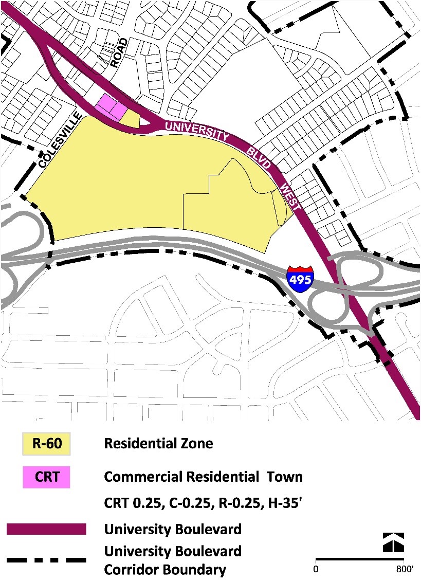
I-495 Interchanges
Four Corners Street Network
Four Corners Street Network
Four Corners Near-Term Recommendations
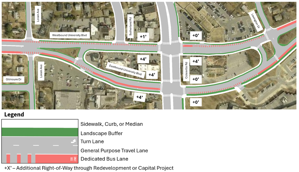
The near-term recommendations for Four Corners focus on improving multimodal safety, particularly for the most vulnerable travelers who are walking, biking, and rolling both to pass through the area and to access destinations within Four Corners. To support near-term implementation, the recommendations maintain the existing one-way couplet configuration of University Boulevard and minimize the need for additional dedicated public right-of-way, as shown in Figure 74.[1]
[1] Note: The US29 Bus Rapid Transit Phase 2 Project, currently in preliminary engineering, is not shown..
This Plan recommends the following changes:
- Reallocate existing right-of-way, minimize the acquisition of additional right-of-way, and relocate curbs along University Boulevard between Lorain Avenue and Lexington Drive to narrow the roadway and provide safer and more comfortable facilities for people walking, biking, and rolling and facilities to improve transit performance. These include:
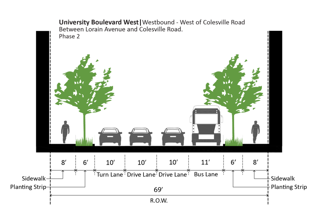
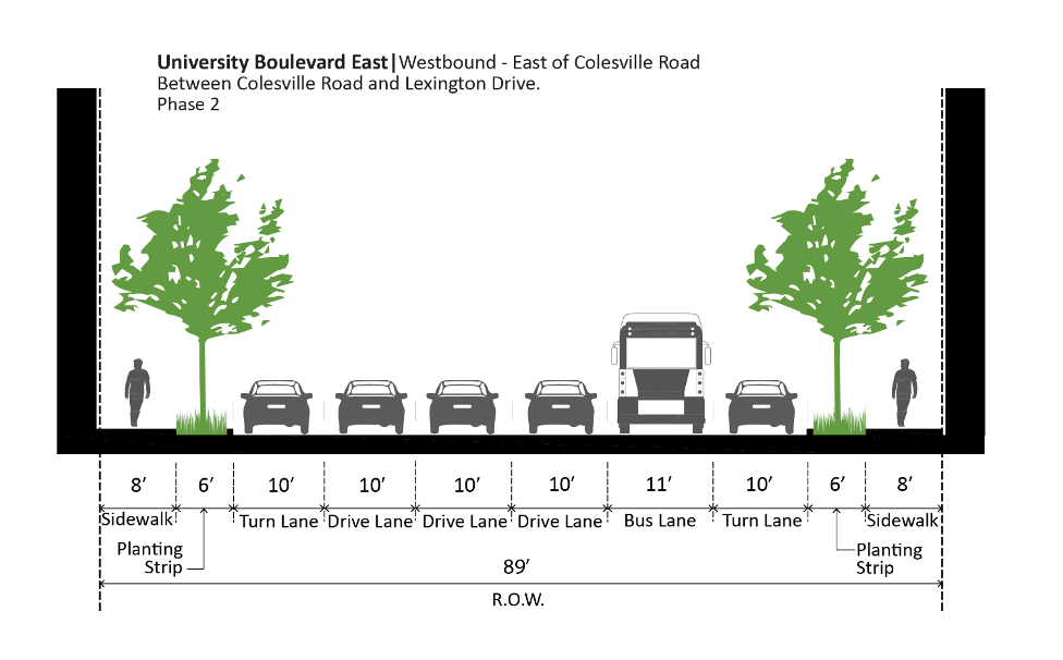
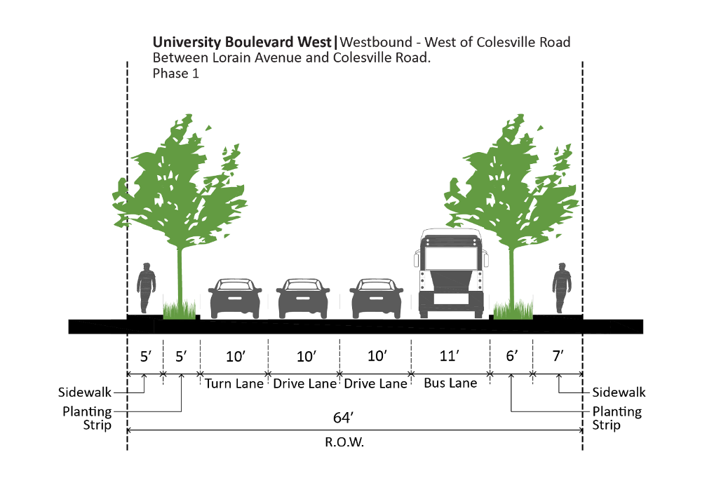
- an 8-foot sidewalk and 6-foot street buffer along each side of westbound University Boulevard, as shown in Figure 75[1] and Figure 76;[2]
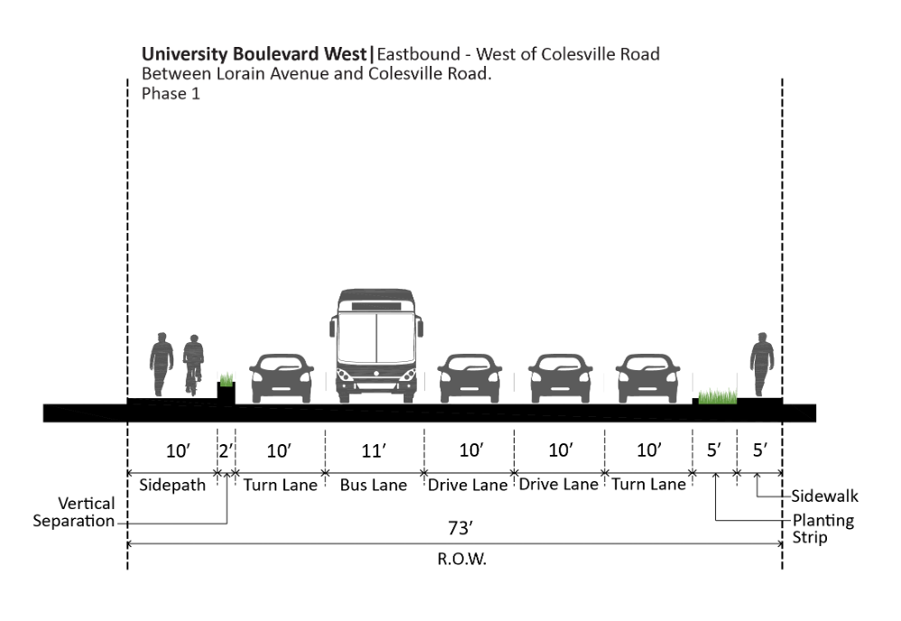
- a 10-foot sidepath and 6-foot street buffer along the south side of eastbound University Boulevard west of Colesville Road, as shown in Figure 77;[3]
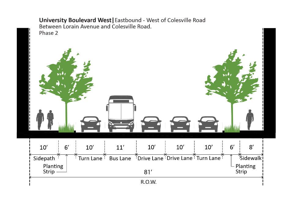
- an 8-foot sidewalk and 6-foot street buffer along the north side of eastbound University Boulevard west of Colesville Road, as shown in Figure 77;
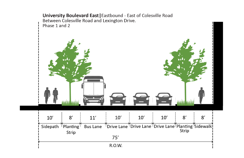
- a 10-foot sidepath and 8-foot street buffer[4] along the south side of eastbound University Boulevard east of Colesville Road, as shown in Figure 78;[5]
- an 8-foot sidewalk and 8-foot street buffer along the north side of eastbound University Boulevard, east of Colesville Road, as shown in Figure 78;
- 11-foot dedicated bus lanes, 10-foot through-vehicle travel lanes, and 10-foot vehicle turn lanes, as shown on Figures 75 through 78.
[1] Cross-section varies along the extent described. Cross section represents STA 63 + 50 as shown on Plat No. 54377.
[2] Cross-section varies along the extent described. Cross section represents a location immediately east of Colesville Road.
[3] Cross-section varies along the extent described. Cross section represents STA 20 + 50 as shown on Plat No. 54377.
[4] If any redevelopment of Montgomery Blair High School relocates the existing 10-foot sidepath, the existing 10-foot street buffer may be reduced to 8 feet; otherwise, the existing 10-foot buffer should remain.
[5] Cross-section varies along the extent described. Cross section represents STA 25 + 50 as shown on Plat No. 54212.
- Repurpose one lane per direction and relocate curbs along University Boulevard between Lorain Avenue and Lexington Drive to narrow the roadway and provide safer and more comfortable facilities for people walking, biking, and rolling. These include:
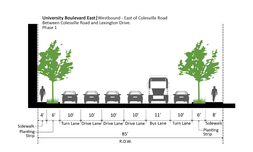
- an 11-foot sidewalk and 8-foot street buffer along the north side of eastbound University Boulevard, as shown in Figure 74;
- a 16-foot Breezeway sidepath and 8-foot street buffer along the south side of eastbound University Boulevard.
- a 10-foot sidewalk and 7-foot street buffer along the north side of westbound University Boulevard, as shown in Figure 75; and
- an 8-foot sidewalk and 8-foot street buffer along the south side of westbound University Boulevard.
- Implement protected crossings at the intersection of Lorain Avenue and University Boulevard.
- Minimize crossing distances—and hence exposure to conflicting vehicle movements—for people walking, biking, and rolling by reducing inside vehicle travel lanes to 10 feet wide and reducing the number of through-vehicle travel lanes on University Boulevard from three per direction to two per direction.
- Reduce the curb radii at all intersecting streets to the minimum consistent with the Complete Streets Design Guide. Prioritize the safety of people walking, biking, and rolling over the speed and convenience of turning vehicles and following vehicles that might need to reduce their speed.
If, through facility planning, implementing partners determine that dedicated bus lanes through Four Corners are not necessary to improve transit performance, right-of-way width shown for dedicated bus lanes should be reallocated to provide safer and more comfortable facilities for people walking, biking, and rolling, prioritizing a Breezeway bicycle facility along the south side of eastbound University Boulevard; any remaining right-of-way width from dedicated bus lanes determined to be not necessary to improve transit performance should be reallocated to reduce the overall cross-section width.
Cross sections depicting an interim condition that does not require additional right-of-way are depicted in Figure 79,[1] Figure 80,[2] and Figure 81.[3] Eastbound University Boulevard East has an existing 10-foot sidepath and 10-foot planting strip on the south side, which should remain unless any redevelopment of Montgomery Blair High School relocates the existing 10-foot sidepath to narrow the existing planting strip to 8 feet wide. With the reallocation of lane widths, additional right-of-way should not be required to implement the 8-foot planting strip and 8-foot sidewalk on the north side of eastbound University Boulevard East.
[1] Cross-section varies along the extent described. Cross section represents STA 63 + 50 as shown on Plat No. 54377.
[2] Cross-section varies along the extent described. Cross section represents a location immediately east of Colesville Road.
[3] Cross-section varies along the extent described. Cross section represents STA 20 + 50 as shown on Plat No. 54377.
If a Breezeway bicycle facility cannot be provided along the south side of eastbound University Boulevard, implement a Breezeway bicycle facility parallel to University Boulevard that connects the planned sidepaths along University Boulevard west of Lorain Avenue to the planned Breezeway bicycle facility along Pierce Drive.
- Implement protected crossings at the intersection of Lorain Avenue and University Boulevard.
- Minimize crossing distances—and hence exposure to conflicting vehicle movements—for people who are walking, biking, and rolling by reducing inside vehicle travel lanes to 10 feet wide and reducing the number of through-vehicle travel lanes on University Boulevard from three per direction to two per direction.
- Reduce the curb radii at all intersecting streets to the minimum consistent with the Complete Streets Design Guide. Prioritize the safety of people walking, biking, and rolling over the speed and convenience of turning vehicles and following vehicles that might need to reduce their speed.
Four Corners Long-Term Vision
This Plan recommends:
- Further study of a more connected network of Town Center Streets to provide increased local connectivity for people walking, biking, rolling, taking transit, and driving. Study options for improving transit performance through Four Corners from Lorain Avenue to Lexington Drive as part of a long-term comprehensive redesign of the intersection of University Boulevard and Colesville Road. Improving multimodal safety should remain the top priority of the study; as such, pedestrian and bicycle safety improvements, including a human scale and reduced pedestrian crossing distances, a Breezeway that connects to bicycle and pedestrian facilities along University Boulevard, and ample street buffers should remain part of the long-term vision. The future study should also explore introducing a more regular street pattern than today’s one-way couplet.
Transit
Transit
Transit Recommendations
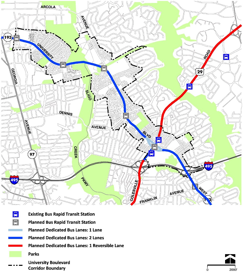
- Provide dedicated transit lanes along Colesville Road (U.S. 29) and University Boulevard (MD 193), as shown in Figure 84.
Ensure that all transit stops are ADA compliant with nearby protected pedestrian crossings.
- Improve the transit environment with new bus shelters along the corridor, especially at proposed BRT stops.
- Support micro-transit alternatives, such as on-demand door-to-door transit, which will contribute to additional transit use.
- In the long-term, explore whether a median BRT, or curb-running BRT approach is appropriate for the University Boulevard corridor, to the extent possible within the existing curb-to-curb dimension.
Bicycle and Pedestrian Networks
Bicycle and Pedestrian Networks
Bicycle and Pedestrian Priority Areas (BiPPA)
Bicycle and Pedestrian Priority Areas Recommendations
- Fund the “University Boulevard: Downtown Wheaton to Four Corners Town Center” BiPPA in the County’s Capital Improvements Program.
Pedestrian Network
Pedestrian Network Recommendations
- Implement a complete network of comfortable walkways and bikeways, connected by safe, protected crossings.
- Implement a complete network of comfortable walkways and bikeways, connected by safe, protected crossings.
- Implement 10-foot sidepaths and 8-foot street buffers along both sides of University Boulevard between Amherst Avenue and Lorain Avenue and between Lexington Avenue and the I-495 interchange.
- Upgrade all intersections with high-visibility continental or ladder crosswalk markings for all pedestrian approaches.
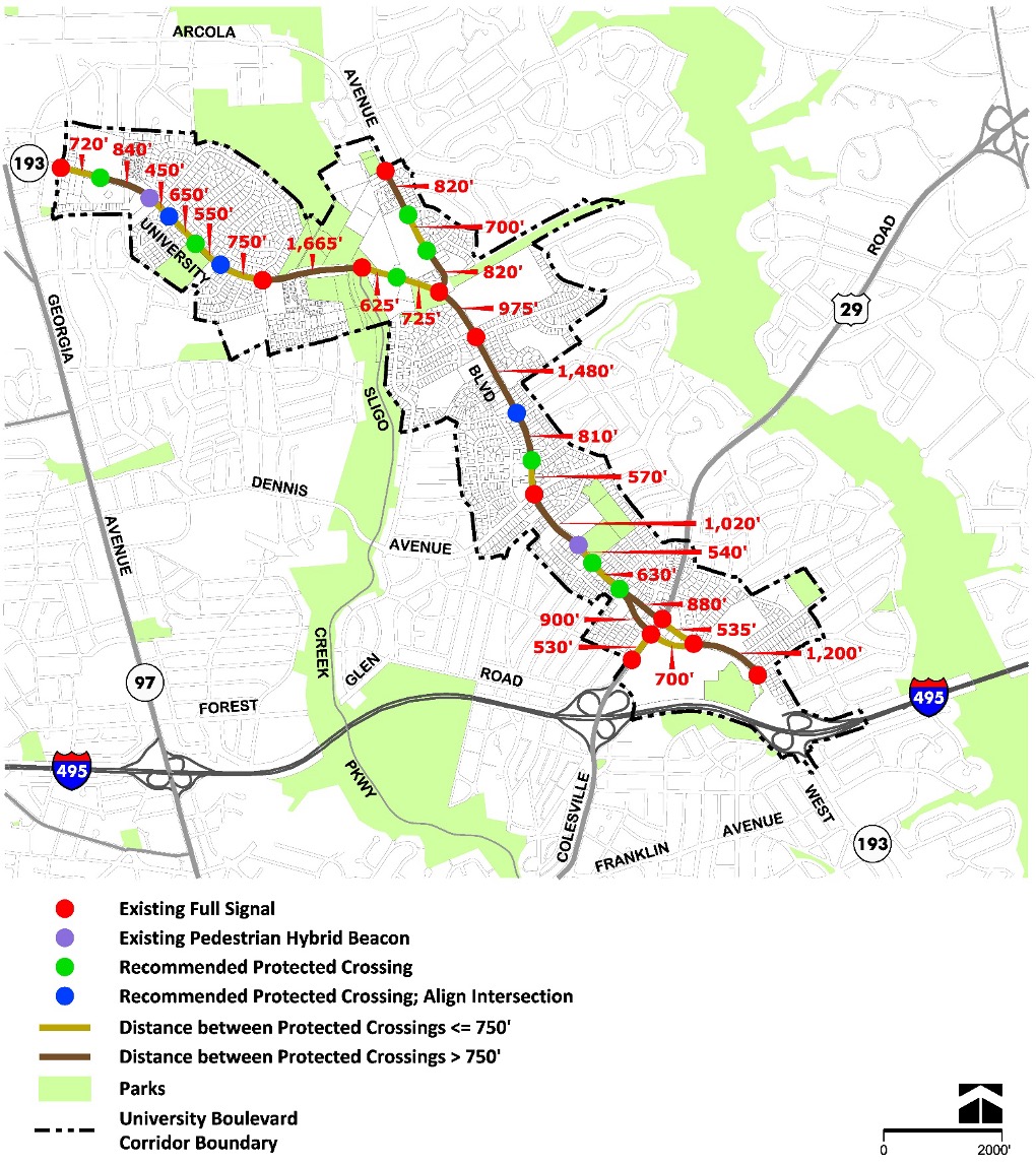
- Provide protected pedestrian crossings that are consistent with the Complete Streets Design Guidemaximum spacing for protected crossings, including at existing and new intersections and at mid-block locations where needed to achieve maximum crossing spacing. High priority recommended protected crossings are shown in Figure 86.
- Ensure ADA accessibility on all public pathways, including sidewalks, trails, and street crossings, in accordance with current best practices.
- Reduce crossing distances for people walking and biking and slow down turning vehicles at intersections.
- Ensure consistent street lighting along the corridor.
- Implement “No Right Turn on Red” restrictions at signalized intersections unless the Director of Transportation or the Director’s designee determines that installing a “No Right Turn on Red” restriction would significantly impair public safety.
- Provide Leading Pedestrian Intervals (LPI) that permit pedestrians advance times to cross MD 193 and intersecting streets at signalized intersections unless the Director of Transportation or the Director’s designee determines that installing a leading pedestrian interval would significantly impair public safety.
- Achieve a Pedestrian Level of Comfort (PLOC) score of 2 or better along and across the right-of-way.
Bicycle Network
Bicycle Network Recommendations
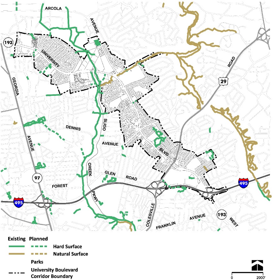
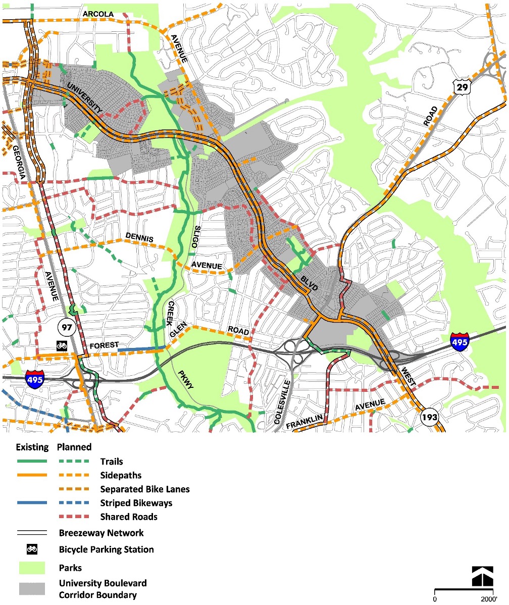
- Implement a complete network of connected low-stress bicycle facilities (Figure 88).
- Implement protected intersections at all intersections with existing or planned separated bike lanes, sidepaths, buffered bike lanes, or conventional bike lanes, consistent with the Complete Streets Design Guide and the 2018 Bicycle Master Plan.
- Implement long-term bicycle parking at destinations such as schools, trails, parks, and public open spaces, and large multifamily dwellings and employment or retail centers.
- Implement a trail connection across I-495 for people walking, biking, and rolling, connecting Colesville Road to Indian Spring Terrace Local Park and Marshall Avenue, consistent with the 2018 Bicycle Master Plan.
- Implement a paved trail connection for people walking, biking, and rolling between Reedie Drive and University Boulevard with redevelopment of the Har Tzeon-Agudath Achim property.
- Implement a paved trail connection for people walking, biking, and rolling between Hannes Street and University Boulevard through the existing 30’ path dedication shown on Plat 3712
Bikeshare
Expand the bikeshare system in the Plan area to serve both residents and visitors from nearby neighborhoods and CBDs. This recommendation is intended to apply to all forms of shared personal mobility technology, which includes but is not limited to dockless bikeshare, electric-assist bikeshare, shared scooters, and other forms of travel to be developed in the future. Potential locations for future bikeshare stations and locations where dockless transportation vehicles should be routinely “re-stocked” include but are not limited to:
- Multi-unit residential sites
- Sligo Creek trailheads
- Planned BRT stations
- Wheaton Forest Local Park
- Breewood Neighborhood Park
- Kemp Mill Shopping Center
- Near Northwood High School, close to University Boulevard and Arcola Avenue
- North Four Corners Local Park
- Woodmoor Shopping Center
- Safeway, close to University Boulevard and Lorain Avenue
- Montgomery Blair High School / Blair Local Park
Micromobility
Micromobility Recommendations
- Install new micromobility corrals in underutilized parking facilities, within available rights-of-way, near planned Bus Rapid Transit stations, and near civic gathering spaces, such as Wheaton Forest Local Park, Sligo Creek Stream Valley Park, Breewood Neighborhood Park, Northwood High School, North Four Corners Local Park, and Montgomery Blair High School.
Community Facilities
Community Facilities
Public Schools
Public Schools Recommendations
As stated above, there is capacity at the elementary, middle, and high school levels, with the reopening of Charles Woodward and Northwood High Schools, to accommodate the Plan’s anticipated growth over the next two decades.
If, during the life of the Plan, a school serving the Plan Area becomes overutilized, MCPS should consider reassigning students to an adjacent or nearby school where there is surplus capacity available before pursuing capital solutions. Public school districts across the country are experiencing enrollment declines that have led to school closures, and the enrollment and capacity utilization trends in MCPS are pointing to a similar direction. While current projections for schools serving the Plan area do not show an impending threat of closure in the near term, an increasing share of schools countywide, including one middle school and one elementary school that serves the Plan area, are operating at a level below the facility utilization range of 80 to 100 percent that MCPS describes as efficient.
Historic Resources
Historic Resources Listed In the Master Plan for Historic Preservation
Evaluate The Following Resources In the Future for Designation In the Master Plan For Historic Preservation
Burial Sites Inventory
Burial Sites Recommended to be Listed in the Burial Sites Inventory
Burial Sites Recommended to be Listed in the Burial Sites Inventory
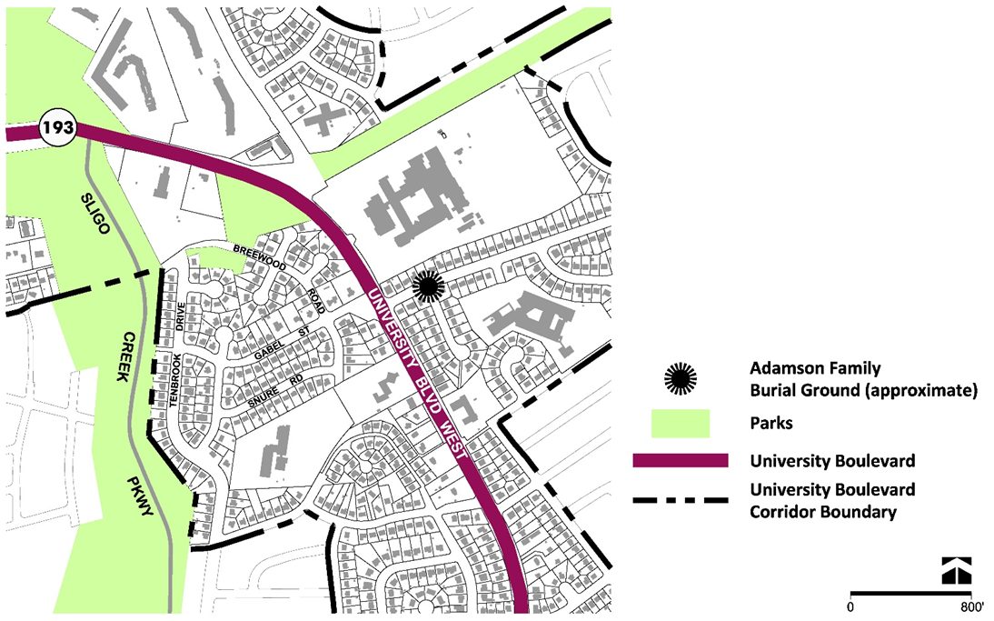
Captain John and Lucy Adamson Family Burial Ground
There is an undocumented burial site approximately near the intersection of Caddington Avenue and Whittington Terrace. The family burial ground for Captain John and Lucy Adamson was first noted in the transfer of property from the estate of John Adamson to Samuel Harwood on November 19, 1779 (Figure 92). The deed stated that Harwood received:
… of every kind advantages and appurtenances to the several tracts or parcels of land belonging or in any manner of wise appertaining (the burying ground excepted where the deceased Captain John Adamson and his wife and family be lie inter[re]d within a stone enclosure) …. (Liber A, Folio 454-455).
The last known record of the cemetery in the land records from 1955 stated:
Subject also to the easement, being a reservation of ½ acre of said land for a family burial ground and convenient Right of Way to and from the same, being the same property described in a deed from James T. Eslin et al to Elizabeth Swart, dated September 13, 1911, … (Liber CKW 2074, Foil 440-444).
The location is considered approximate because there are no visible remains and historical records do not specify an exact location. The approximate location is based on the boundaries of the historical Adams property and the location of pathways in 1950s aerial imagery that may be associated with the right of way mentioned in the 1955 deed.
The Adamson family bound convicted indentured servants—convicted felons transported to America and forced to labor for seven or fourteen years based on the severity of their crime—and enslaved African Americans. The burial location for these individuals remains unknown.
Recommendations:
- Update the Burial Sites Inventory to list the approximate site of the Captain John and Lucy Adamson Family Burial Ground.
- Consider possible impacts to the cemetery location as warranted during development review.
- Per §18-31 of the County Code, preserve and protect burial sites during the subdivision review and approval process.