Skip to the content
The Maryland-National Capital Park and Planning Commission
Home / Planning / Communities / Upcounty Planning / Clarksburg / Clarksburg Master Plan and Hyattstown Special Study Area

Clarksburg Master Plan and Hyattstown Special Study Area

Clarksburg Master Plan & Hyattstown Special Study Area

Clarksburg rendering

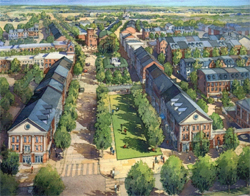
The 1994 Clarksburg Master Plan and Hyattstown Special Study Area establishes a long-range vision of Clarksburg as the northern-most population center along the I-270 Corridor. The plan implementation spans decades, so development will be staged over time. The plan details a vision of Clarksburg as a transit- and pedestrian-oriented community surrounded by open space.

Several amendments to the Clarksburg Master Plan & Hyattstown Special Study Area Master Plan have been approved:

Approved and Adopted – June 1994

GVMP 1985


View the Clarksburg Master Plan & Hyattstown Special Study Area (1994) (pdf, 29 MB)

The complete document is represented by the index below:

  • Introduction
    • Overview
    • Past Planning Efforts
    • Plan Determinants
    • Proposed Concept Plan for Clarksburg
    • Conformance with the Maryland Planning Act of 1992 and the General Plan for Montgomery County
    • Overview of the Plan Adoption Process
  • Vision for the Future Overview
    • Policy Statements
    • Town Scale of Development
    • Natural Environment
    • Greenway Network
    • Transit System
    • Hierarchy of Roads and Streets
    • Town Center
    • Transit-and Pedestrian-Oriented Neighborhoods
    • Employment
    • Farmland  Preservation
    • Staging
  • Land Use Plan Overview
    • Plan Terminology & Summary of End-State Development Potential
    • Land Use Recommendations by Geographic Area
      • Town Center District
      • Transit Corridor District
      • Newcut Road Neighborhood
      • Cabin Branch Neighborhood
      • Ridge Road Transition Area
      • Brink Road Transition Area
      • Hyattstown Special Study Area
      • Ten Mile Creek Area
  • Zoning Plan Overview
    • Existing and Proposed Zoning Plan
    • Relationship of Proposed Zoning Plan to Key Land Use Objectives
  • Transportation and Mobility Plan
    • Introduction
    • Plan Objectives
    • Transit Plan
    • Street and Highway Plan
    • Summary of Key Roadway Recommendations
    • Right-of-way Recommendations
    • Recommended Rustic Road Designations
    • Bikeway Plan
  • Environmental Plan
    • Overview
    • Watershed Analysis
    • Plan Recommendations Relating to Watershed and Sensitive Area Protection
    • Relation of Environmental Plan to 1992 Maryland Planning Act
    • Plan Recommendations Relating to Area-wide Environmental Concerns
  • Public Facilities
    • Overview
    • Greenway Network
    • Parks and Recreational Facilities
    • Proposed Park System
    • Public Schools
    • Community Facilities
  • Clarksburg Historical Resources
    • Overview
    • Background
    • Historic Districts
    • Individual Resources
  • Implementation Strategies
    • Overview
    • Recommended Zoning Actions
    • Staging Recommendations
    • Staging Implementation Mechanisms|
    • Recommended Guidelines for the Review of Subdivisions and Site Plans in Clarksburg
    • Recommended Policies Needing Additional Legislative Action

Technical Appendix

  • Plan Introduction
  • Land Use Plan
  • Transportation and Mobility Plan
  • Environmental Plan
  • Implementation Strategies
  • Resolutions of Approval and Adoption

 List of Figures

  1. Clarksburg and the 1-270 Corridor
  2. Plan Determinants: Natural Features
  3. Plan Determinants: Development Commitment
  4. Proposed Concept Plan for Clarksburg
  5. Relationship of Clarksburg to Wedges and Corridors
  6. Clarksburg Master Plan Development Process
  7. Town Scale of Development
  8. Natural Environment
  9. Greenway Network
  10. Transit System
  11. Hierarchy of Roads and Streets
  12. Town Center Concept Diagram
  13. Transit- and Pedestrian-Oriented Neighborhoods
  14. Employment
  15. Farmland Preservation
  16. Staging
  17. Generalized Land Use Plan
  18. Analysis Areas
  19. Town Center District Land Use Plan
  20. Town Center Illustrative Sketch
  21. Clarksburg Historic District Buffers
  22. Transit Corridor District Land Use Plan
  23. Newcut Road Neighborhood Land Use Plan
  24. Newcut Road Neighborhood Illustrative Sketch
  25. Newcut Road Neighborhood Concept Diagram
  26. Cabin Branch Neighborhood Land Use Plan
  27. Cabin Branch Neighborhood Concept Diagram
  28. Brink Road Transition Area Land Use Plan
  29. Hyattstown Special Study Area Land Use Plan
  30. Hyattstown Concept Diagram
  31. Hyattstown Sketch
  32. Land Use Recommendations for Southern Portion of Hyattstown Transition Area
  33. Ten Mile Creek Area Land Use Plan
  34. Soil Suitabilities for Agriculture West of 1-270
  35. Areas Affected by Master Plan Recommended 15% Impervious Limits
  36. Existing Zoning(As of 1993)
  37. Zoning Plan. 97
  38. Areas Proposed for Zones Requiring Future County Council Action
  39. Generalized Highway and Transit Plan
  40. Proposed lnterchange Design Concepts
  41. Rustic Road Recommendations
  42. Bikeway Plan
  43. Watersheds
  44. Environmental Synthesis
  45. Sensitive Areas Protection
  46. Roadway Noise Impact Areas
  47. Proposed Park and Open Space System
  48. Existing and Proposed Public Facilities
  49. Historic Resources
  50. Recommended Sewer and Water Staging for Clarksburg
  51. Special Protection Areas
  52. Proposed Road Sections
  53. Clarksburg: Staging of Development

 List of Tables

  1. Recommended Housing Mix by Geographic Area
  2. Summary of Maximum End-State Development Potential by Geographic Area
  3. Summary of TDR Zone Recommendations
  4. Summary of Zoning Classifications
  5. Zoning Recommendations by Geographic Area
  6. Identification of Master Plan Strategies for Improved Transportation in the Study Area
  7. Highway and Street Classifications in the Clarksburg Master Plan and Hyattstown Special Study Area
  8. Summary of Characteristics Associated with Rustic and Exceptional Rustic Roads
  9. Clarksburg Master Plan Rustic Road Recommendations
  10. Bikeway Classifications
  11. Summary of Key Protection Strategies for Sub-Watersheds in Clarksburg Master Plan Study Area
  12. Description of Greenway
  13. Existing and Proposed Park System in the Clarksburg Study Area
  14. Public Schools by High School Cluster Serving Clarksburg Master Plan and Hyattstown Special Study Area
  15. Community Facilities Recommendation
  16. Master Plan Preservation Strategies for Historic Districts
  17. Clarksburg Master Plan Study Area Historic Resources
  18. Stage 1
  19. Stage 2
  20. Stage 3
  21. Stage 4

Staff Contact

Jamey Pratt
301-495-4588
Email