Project Overview


Montgomery Planning recently updated the Public Benefits Point System for Commercial-Residential and Employment Zones. This effort did not rezone any parcels or alter existing development, rather it updated the system used to evaluate new development and determine to what extent a development must provide corresponding public amenities. These changes will allow different neighborhoods to evolve with market trends and community needs while still enjoying the benefits of new development alongside what already gives the neighborhood its character. This update will also better align the point system with countywide priorities as envisioned in initiatives like Thrive Montgomery 2050, the Climate Action Plan, and implementation of the county’s Racial Equity law.
Update to the Implementation Guidelines
The Implementation Guidelines are a tool for administering the review of proposed public benefits associated with the Optional Method of development in the Commercial Residential (CR) and Commercial Residential Town (CRT) zones within the regulatory process. The previous document adopted in 2017 implemented the previous public benefit system, and these Implementation Guidelines have been updated to reflect the new public benefit system approved under ZTA 25-05, which takes effect in January of 2026. The Implementation Guidelines were adopted by the Planning Board in November of 2025 and are available in the link below. If you have any questions or concerns, please reach out to Grace Bogdan, grace.bogdan@montgomeryplanning.org.
How does the current point system work?
This system ensures the delivery of high-quality public amenities, maintains equity across negotiations for public benefits with applicants, provides transparency and certainty about the review process, and expedites the overall timeline for regulatory reviews.


Background

Montgomery County contains a wide range of neighborhoods—rural agriculture, mid-density suburbs, and big-city downtowns. Our zoning code ensures that residents countywide benefit from these different places while also maintaining what works about each. As communities grow, new development gets added to existing neighborhoods, bringing with it new features and amenities as well as challenges. The county’s Point System and associated Implementation Guidelines provide a framework to review proposals for new construction in commercial, residential, and office-park areas—also called “CR and employment zones”—that would add density in a practice known as the “optional method of development.” This system requires a developer to provide public benefits alongside their project in an exchange that delivers high-quality, needed amenities to the community. The formulas for allocating public benefit “points” to each applicant maintain parity across negotiations, ensuring that every project complies fairly with the calculated benefits required.
Public benefits
Applicants who want to build under the optional method of development must choose from a menu of public benefits that will be graded under the point system and analyzed for their ability to achieve master plan priorities. In return for the public benefits, they are allowed to build to the density and height shown on the zoning map. Most master plans in Montgomery County specify how to prioritize points to achieve plan goals for an area.
Development proposals earn points based on the amenities they plan to provide, with the total they need to reach determined by the project’s proposed FAR. Amenities, both within the project area and nearby, can include (but are not limited to):
- Affordable housing
- Major public facilities, like a library or a site for a new school
- Public parking, art, or open space
- Safe and attractive pedestrian connections
- Enhanced accessibility for people with disabilities
- Historic resource protection
- Sustainable design of buildings and sites
Process

This project will begin with an extensive data collection and stakeholder outreach phase. Staff will collect and analyze data from all projects approved under the current policy across the county since 2010 and review how the current system has performed to date. In addition, we will hold multiple in-person and virtual meetings, townhalls and working sessions with a variety of stakeholders including architects, engineers, attorneys, real estate developers, partner agencies and business owners and resident representatives from neighborhoods where this type of zoning is in place.
A consultant will provide an additional review of the points system by analyzing the cost of providing public benefits and comparing how that cost relates to the “value” of the incentive density approved by the planning board. The consultant will also benchmark the current point system with regional and nationally successful programs, identifying best practices for incentive zoning implementation in similar markets.
Based on the data analysis, consultant review and stakeholder input, staff will provide a set of actionable recommendations to modernize the policy for the planning board’s review. Information will be shared periodically with all stakeholders and the planning board at key milestones of the project with opportunities for providing continued guidance. Once the board reviews and finalizes these recommendations, they will then be transmitted to the county council for its review and consideration.
Community Engagement
Equitable community engagement is central to all of Montgomery Planning’s work and the planning team will use a three-pronged approach to engage community members and stakeholders:
- Creating a technical working group with representatives from the various user groups of the current Point System including real estate and design professionals, county agency partners, and land use attorneys, among others.
- Meeting one-on-one with various groups affected by the current Point System including public agencies, non-profits, advocacy groups, and business representatives, among others.
- Hosting a variety of in-person and virtual meetings which will be open to the public with opportunities to question, comment and share ideas.
Throughout the engagement process, the planning team will explore how to best highlight and reflect the interests of stakeholders. This process will start with listening sessions to gather feedback and during subsequent stages, staff will present preliminary ideas, solicit further stakeholder input, and share the preliminary recommendations.
The feedback and other information gathered during the engagement process will be used by planning staff to prepare recommendations for consideration by the planning board and elected officials.
Frequently Asked Questions
Applicants who want to build under the optional method of development must choose from a menu of public benefits that will be graded under the point system and analyzed for their ability to achieve master plan priorities. In return for the public benefits, they are allowed to build to the density and height shown on the zoning map. Most master plans in Montgomery County specify how to prioritize points to achieve plan goals for an area.
Development proposals earn points based on the amenities they plan to provide, with the total they need to reach determined by the project’s proposed FAR. Amenities, both within the project area and nearby, can include (but are not limited to):
- Affordable housing
- Major public facilities, like a library or a site for a new school
- Public parking, art, or open space
- Safe and attractive pedestrian connections
- Enhanced accessibility for people with disabilities
- Historic resource protection
- Sustainable design of buildings and sites
Commercial-Residential (“CR”) Zones are meant to encourage more mixed-use, walkable neighborhoods through development incentives, in line with Thrive Montgomery 2050’s Complete Communities vision.
CR zones comprise several types that allow for development at different densities and heights. By tying use, density, and height together, they provide greater predictability and direction on what can be built where and how a property can be used relative to its surroundings. Together, these zones encourage a mix of uses, and they help create more interactive streetscapes and meaningful public spaces. In Montgomery County, CR zones further create jobs and services, improving residential quality of life countywide.
The three main types of CR zones—CR, CRN, and CRT—differ in intent as well as in the size and kinds of development allowed. These various types can soften transitions between mixed-use and residential areas and may address concerns about the proximity of some uses to single-family residential properties, like parking and drive-through designs.
Only the CRT and CR zones allow for “optional method development,” which means developers can provide certain public amenities in exchange for being able to create larger structures for more varied uses. Requirements are calculated through a points system to ensure that the new development’s impact on the community is sufficiently balanced by its benefits.
The system incentivizes applicants to provide certain public benefits in exchange for obtaining additional density and height for their projects, based on transparent and publicly available evaluation criteria. Projects must achieve a minimum points total depending on their size, intensity, and location and propose public benefits they will provide in line with that score. Applicants may choose from a range of specified public benefits; streetscape improvements are “worth” up to 20 points, for instance, while a major public facility, like a library, could be up to 70 points.
This system ensures the delivery of high-quality public amenities, maintains equity across negotiations for public benefits with applicants, provides transparency and certainty about the review process, and expedites the overall timeline for regulatory reviews.
Many jurisdictions across the country utilize similar systems, though few have conducted this kind of review of efficacy. Some rely more specifically on project-based options for amenities, while others develop a menu of public benefits that may be provided in exchange for development incentives.
The CR and Employment zones ultimately enable development in strategic locations, such as near metro stations or major employers. Through the point system, we leverage private development to proactively create needed public amenities while evaluating every proposed project in the same objective fashion. All this ensures that the County can direct development in general—and the provision of public amenities specifically—to locations and according to types that are best for realizing our Thrive Montgomery 2050 vision and other countywide goals.
This effort will not rezone any parcels or alter existing development. It will simply update the system we use to evaluate new development and determine to what extent a development must provide corresponding public amenities. These changes will allow different neighborhoods to evolve with market trends and community needs while still enjoying the benefits of new development alongside what already gives the neighborhood its character.
For instance, land near transit stations is in demand for development, so CR zoning ensures that the community benefits from that desirable development, both directly in the form of new and improved uses like retail and restaurants and indirectly in the form of public amenities such as a new park or affordable housing, are provided by the developer.
This update will also better align the point system with countywide priorities as envisioned in initiatives like Thrive Montgomery 2050, the Climate Action Plan, and implementation of the county’s Racial Equity law.
Definitions
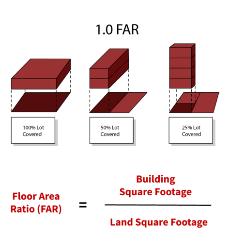
Floor Area Ratio: The ratio of the gross floor area of a building to the area of the tract on which it is located. For example, a building with a gross floor area of 43,560 square feet on a one-acre tract would have a 1.0 FAR. Parking and non-leasable space in the building are generally excluded from the computation.
Optional Method Development: a zoning procedure used in some Commercial/ Residential (C/R) and Employment zones that encourages comprehensive planning and mixed-use development. Under the optional method, higher densities are allowed in exchange for significant public amenities and facilities to support that additional density.
Sketch Plan: a conceptual design that establishes a basic building, open space and circulation framework for future, more detailed planning approvals. It serves as an initial agreement between the applicant and the Planning Board about the public benefits that will be provided for the proposed density.
Site Plan: A site plan is a detailed plan, required only in certain cases, that shows proposed development on a property in relation to immediately adjacent areas. It indicates roads, walks, parking areas, buildings, landscaping, open spaces, recreation facilities, lighting, etc. The Planning Board approves the site plan after sketch plan approval and before building permits can be issued.
Incentive Density: the amount of a building’s floor area greater than the maximum development allowed without providing public benefits. To support this added floor area, public amenities must be provided, and additional public review is required.
Building Lot Termination (BLT): a transferable development right created from a tract of land that is at least 25 acres. The land must be capable of being served by an individual sewage treatment unit that meets the requirements of Chapter 27A (Montgomery County Code) and applicable regulations issued under that chapter. It must be in the county Agricultural Reserve (AR) zone and transferred by a building lot termination (BLT) easement under Chapter 59 of the Montgomery County Zoning Ordinance. When a BLT easement is recorded in the land records, the right to build a dwelling unit on that land in the AR zone is extinguished by the easement.
Commercial/Residential Zones: The Commercial/Residential zones (including CR and CRT) are a family of mixed-use zones that establish the zoning classification, maximum total density, nonresidential density, residential density and building heights. Learn more.
Transit-oriented development: a type of urban development that maximizes the amount of residential, business and leisure space within walking distance of public transport. It promotes a symbiotic relationship between dense, compact urban form and public transport use.
Moderately priced dwelling unit (MPDU): townhomes and condominiums that area available to first-time home-buyers who have a moderate household income. Learn more about Montgomery County’s MPDU program.
Zoning Types
Montgomery Planning uses zoning to ensure that any development fits into the context of an existing community. With specific density and height limitations built in, a zone provides certainty for residents about the types of development—and amenities—they can expect. Any zone definitions or changes to a type of zone must be designated on the County’s official zoning map approved by the County Council.
CR Zoning: Commercial-Residential (CR) zones allow for mixed-use development up to a certain density, beyond which developers must provide public benefits to move forward with their project. In Montgomery County, this requires they comply with a point system to build denser than 0.5 FAR; CR zones may permit density of up to 8.0 FAR depending on the site, and with a maximum building height of around 300 feet.
CRN Zoning: Within the CR family, CRN zoning allows limited commercial uses, such as services commonly used by neighborhood residents. Development in a CRN zone requires buffering for certain moderately intense uses, such as a bed and breakfast. Those deemed too intense are prohibited, as are densities above 1.5 FAR.
CRT Zoning: Within the CR family, CRT zones permit more intensive uses than CRN zones, such as a hospital, although there are still restrictions on some commercial and flexible uses. CRT zone densities are limited to between 0.25 and 4.0 FAR.
LSC Zoning: The Life Sciences Center (LSC) zone is primarily a work-centric zone where retail sales and personal services are intended for the convenience of employees and residents amid research, development, education, and related activities at research, academic, and clinical facilities that advance the life sciences, health care services, and applied technologies. This zone helps retain an environment conducive to advanced technology research, development, and production.
EOF Zoning: The Employment Office (EOF) zone is intended for office and employment activity, with flexibility in building, circulation, and parking lot layout and only limited residential and neighborhood commercial uses.
Standard method of development: The standard method of development refers to by-right development in commercial zones—that is, development permitted without approval from the Montgomery County Planning Board—which is allowed for most development under 0.5 FAR. Under the standard method of development, projects do not need to provide public benefit points.
Optional method of development: Under the optional method of development, developers must provide public benefits to build beyond a certain permissible density in CR and Employment zones. The point system determines what benefits are required for the proposed density and project.
TDR: The transfer of development rights (TDR), as authorized by law, to another tract of land, such as conveying unused FAR from a preserved historical site to a commercial development.
Project timeline
-
Phase 1: Pre-Planning, August–December 2022
-
Phase 2: Spread the Word, January–March 2023• Project kick-off
• Planning Board scope of work briefing -
Phase 3: Preliminary Data Collection and Analysis, January–September 2023• Complete analysis
• Listening sessions
• Present findings of analysis to stakeholders and Planning Board -
Phase 4: Preliminary Recommendations, Spring 2024
-
Phase 5: Planning Board Review and Work Sessions, Summer 2024• June 6: Watch video
• June 13: Watch video
• June 20: Watch video
• Transmit planning board draft to Council -
Phase 6: County Council Briefings and Approval, October–December 2024• Council review
-
Phase 7: Council review of Zoning Text Amendment, April- July 2025• April 29: Council introduction of Zoning Text Amendment ZTA 25-05
• June 10: Public Hearing for ZTA 25-05
• July: Council adoption of ZTA 25-05, effective January 1, 2026. Review Ordinance No. 20-01 -
Phase 8: Review of Implementation Guidelines• November 20: Planning Board adopted the updated Implementation Guidelines.