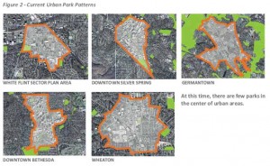
Planning
Planning for Access to Parks
Yesterday the Planning Board discussed a draft Park, Recreation and Open Space Plan (PROS Plan) that lays out a strategy to ensure access to open space for County residents:
The purpose of the 2012 PROS Plan is to estimate the future needs for park and
recreation facilities and natural, historic and agricultural resource preservation
and to develop specific service delivery strategies to meet future needs through
the year 2022 and beyond.
This broad-ranging Plan covers traditional park and trail facilities on public and private land, but also delves into preservation and enhancement of historic, cultural, and agricultural resources.
Like the recently created Parkscore system established by the Trust for Public Land, important parts of the PROS Plan are establishing:
- a methodology to determine where open space is lacking,
- strategies to rectify identified problem areas, and
- guidelines to implement the creation of new open space.
A quick overview of our urban areas shows that significant green spaces are lacking in our densest areas.
Parkscore has rated Washington, DC 5th among the 40 largest cities ranked.
And with the metrics used, the County should rank quite well. Many of the County’s parks, however, are right outside our metro station areas. For example, I regularly visit Wheaton Regional Park, which is only a 1.7 mile walk from my home in the southern part of the Wheaton CBD.
Still, opportunities exist within the central core to provide green space and respite for residents, employees, and visitors. How these open spaces are created is, of course, the question. And it is one that the PROS Plan begins to answer.
The record remains open until June 1st, so please contact the project manager at MCP-PROSPlan2012@Montgomeryparks.org.
What a fun toy! Mapnificent shows you how far you can travel on transit from any address for several cities around the world.
You can choose the travel time along a sliding bar and choose specific addresses or drag a pin on the map around. Here’s the blob from the Planning Department’s address set at 30 minutes:
I was able to quickly look at Chicago and Philadelphia, two cities I’ll be visiting soon, and the times looked about like I’ve experienced before (as does Silver Spring’s). Nothing for Providence, another city I’ll be visiting this summer, although I know RIPTA has a decent system.
Maybe more soon.
More info and examples were posted on The Atlantic Cities site.
| What: |
![]() 2011 NCPC Speaker Series |
||
| When: | Tuesday, June 7, 2011 6:30 – 8:00 PM |
||
| Where: | Koubek Auditorium – Crough Center for Architectural Studies School of Architecture and Planning Catholic University of America |
||
As a city filled with historic structures and landmarks, architectural preservation in the nation’s capital receives a lot of attention. Yet, as Washington continues to evolve, there exists a growing need for new development and a desire for more modern and inventive architecture. Making sure the two can successfully co-exist is the responsibility of the agencies involved in the planning and design review process. Join a panel of distinguished design and planning experts as they explore how Washington D.C. can welcome new innovative design into its urban fabric and preserve its architectural heritage.
This event is being held in partnership with Catholic University School of Architecture and Planning and AIA DC. Attendance is free and open to the public. RSVP is encouraged.
learning with legos at NBM

"I never design a building before I've seen the site and met the people that will be using it." Frank Lloyd Wright
The ongoing Lego (R) exhibit, Towering Ambition, at the National Building Museum has some very cool models of famous buildings, but also provides a play area for kids and families.

More interesting than the models, however, are the prompts about land use and community planning hanging around and adorning the space where kids (and adults) can play with the Legos.
Rather than focus on cool buildings, like the exhibit, these prompts ask budding designers to think about places beyond the bounds of an individual building, to think like a town planner (and a rather progressive one at that).
- Unfortunately the prompts still relegate land uses to separate building forms, but do suggest locating them near one another.

If not integrated uses, at least mixed-use planning. Basis of an interactive civics curriculum on planning?
I think their next exhibit should be reproductions of great plazas, parks, and streets!
Parking is one of the single-most controversial aspects of development splitting generally along the lines of “we don’t require enough” versus “we require too much”. Parking management is an issue that affects congestion, pollution, pedestrian comfort & safety, potential for open space and green areas, business revitalization feasibility, and many other topics. With so many factors being effected, it’s probable that no model we develop will make everyone (or maybe anyone) completely happy. But it is our task to try.
As many know, the parking ratios we apply to commercial uses have not been updated for decades. And our shared-use model is still based on maximum demand. With this in mind, the County’s DOT and MNCPPC were directed to work with a consultant to examine our existing practices and develop new ideas for establishing parking ratios in our mixed-use/commercial zones. Their report was developed over several months and presented to the Planning Board, County Council committees, the Zoning Advisory Panel (which advises the Planning Department on the ongoing zoning ordinance rewrite), and numerous stakeholder groups of citizens, property owners, developers, bike/transit advocates, and agencies.
The study was focused on Division 59-E (parking requirements) and Chapter 60 (parking lot district [PLD] regulations) of the County Code and our consultant, Nelson/Nygaard, was tasked with several objectives including to:
- Update the PLD program;
- Assess current PLD performance;
- Identify opportunities for PLD improvement;
- Assess interaction between 59-E and 60;
- Update current 59-E requirements;
- Promote shared parking;
- Support local business;
- Increase flexibility; and
- Make standards clearer and more predictable.
A large amount of the initial phase of the study was focused on analysis of our code, best practices in other jurisdictions, and professional models. Some of the more innovative practices included:
- No minimum parking requirements such as Ann Arbor, MI (Public Parking & TDM Strategies Plan);
- Flexible parking pricing such as in San Francisco (SF Park);
- Broad use of employee transit benefits and assurance that parking revenues target local transportation-related investments such as Boulder, CO (Parking Best Practices Review);
- Targeting parking revenues to streetscape improvements to increase pedestrian comfort and safety such as Pasadena, CA (summary at walkablestreets.com); and
- Obtaining shared parking in private development such as Arlington, VA (Columbia Pike Parking Strategy).
Also, the latest industry models from the Urban Land Institute and Institute of Transportation Engineers were studied and compared side-by-side with the benchmark peers, best practice codes, policy-based models, and density-based models. (See the Appendices of the Report for more details.)
After a thorough analysis of the existing code, data on local usage and revenue, and the practices outlined above, a model was drafted. Part 2 will lay out the basics of this model.
Post Script: My vote is for public art integrated into every garage….
Adaptive reuse of existing buildings for agriculture: Plant Chicago – vertical farming and industrial reuse.
Take a quick look at their philosophy in 2 minutes.
Don’t think we’d have any 40-story buildings, but what if we used less and converted … i don’t know … some of our numerous self-storage facilities to vertical farms?
When it comes to the built environment, the Washington region has long been one of the proving grounds for Planning.
From the first-ever National Planning Conference in 1909 to the demonstration of New Urbanism at Kentlands, Washington has benefited from planning ideas that often seemed far-fetched at the time.
Greenbelt, Maryland is no exception. It’s the best-preserved example of New Deal-era utopian town planning in the United States, and has been named a National Planning Landmark. This Saturday, I’m leading a bike tour of the community (details below). I hope you can make it.
About Greenbelt:
Faced with housing shortages, a decimated economy, and deteriorating conditions in cities, the Roosevelt Administration, as a part of the New Deal, set out to build 4 “greenbelt towns” as an example of how suburban development could and should move forward.
Partially inspired by England’s garden city movement, Greenbelt was intended to be a self-contained community surrounded by a green belt of parks, forests, and farms. Today, Greenbelt is not as isolated, but the historic center maintains its park-like setting.
Planning of the town was holistic, in keeping with the principles of the New Deal. In addition to housing, a commercial center was constructed. Civic buildings included an elementary school/community center and recreational buildings.
Perhaps most unique in the design was that residential buildings were turned “inside-out”. Residential structures have their main entrances on the “garden side.” The design of the community meant that pedestrian paths wound through superblocks, where buildings were turned inward toward parks, gardens, and social interaction. At the rear of the units is the street, the so-called “service side.”
Much of the architecture in the community is based on the International style with Art Deco elements. Some elements which are now becoming more common in urban design have been present in Greenbelt for over 7 decades. One example is the “shopping court” at the Roosevelt Center, where shops front on a pedestrian plaza, and parking is in the rear.
Greenbelt was designed with the automobile in mind, but it was not designed for the automobile. I think this is the largest and most crucial difference between Greenbelt and the prototypical post-war suburb. The community is walkable, traffic is calm, and despite being surrounded by sprawl, cars do not dominate the landscape.
The greenbelt towns were intended to be prototypes for suburban development. But the experiment didn’t become typical of suburbia. It did, however, help to inspire several planned communities, including Reston in Virginia, and Columbia and Montgomery Village in Maryland.
The Tour:
This Saturday, October 2, I’ll be leading a bike tour of the community. The tour will be approximately 4 miles in length and will include a tour of the Greenbelt Museum. It will cost $5.
The tour will begin and end at the Greenbelt Metro station. It starts at 1pm and will be complete by 5pm.
If you’re interested in attending or have questions, please email me at mcjohnson@ggwash.org.
As we start writing the code for the new zoning ordinance, a “big picture” view seems in order. The biggest-picture formula in climate change, called the Kaya identity, is:
- F = Global CO2 emissions (combustion, flaring of natural gas, cement production, oxidation of nonfuel hydrocarbons, and transport)
- P = Global population (total number of human beings)
- g = Consumption per person (gross world product divided by population)
- e = Energy intensity of gross world product (global energy consumption divided by gross world product)
- f = Carbon used to make energy (global carbon dioxide emissions divided by global energy consumption)

Factors in the Kaya identity, F = Pgef = Pgh, as global averages. All quantities are normalized to 1 at 1990. Intensities are calculated by using G M (Left) and G P (Right). In both Left and Right, the black line (F) is the product of the red (P), orange (g), green (e), and light blue (f) lines (Eq. 2) or equivalently of the red (P), orange (g), and dark blue (h) lines (Eq. 3). Because h = ef, the dark blue line is the product of the green and light blue lines. Source: PNAS.
The most obvious thing about this equation – if you remember even grade-school math – is that to reduce F to zero, any of the four factors on the right must go to zero. Since even the most misanthropic earth-firster has not suggested that global population should be reduced to zero (or if they have and taken their own advice, they aren’t here to argue against me), efforts at reducing F should concentrate on the areas where we can have the most impact.
Here are a few basic suggestions on the issues over which we (planners and designers) have influence.
We can minimize g & e (consumption-related factors) by:
- Decreasing the need for energy for transport by co-locating as many jobs, houses, services, and amenities as is practical;
- Providing resource-sharing opportunities (like mass-transit and libraries);
- Allowing for development with minimal resources (one wall between two residences requires less resources than two walls and a strip of grass);
- Allowing for optimally efficient building siting (don’t penalize development with setbacks or height restrictions when those features are used to optimize passive energy use);
- Encouraging recycling, reuse, and retrofits of existing infrastructure;
- Providing flexibility for more locally-sustaining economic development (farms, markets, co-ops, craftspeople and artisans, localism generally);
We will have to wait for the scientists to provide an f that equals zero, but we can help minimize f (carbon use for energy) by:
- Ensuring that rules don’t get in the way of technology that uses renewable energy sources (geothermal, wind, solar); and
- Providing incentives to encourage use of the available renewable energy sources.
Thanks to Wired for reminding me of the useful perspective provided by this formula as we look to finalize some thoughts on sustainability and our zoning code rewrite efforts. Further suggestions to add to the list above are, of course, welcome.
Reminder: May 27, 7:30 ReThink Energy w/A. Michael Schaal.
On communities having more input. Not sure I’m down with the program advocated in all – or even most – cases. But important for particularly important locations and projects, e.g., civic buildings and open spaces.
An example of the grassroots process advocated above that did work:Â Paint Your Faith.
On artists taking to the streets. But what isn’t more fun in Rome?
Share something in your local park. This is what the right to assembly is all about – knowledge pursued in public spaces.
Last, as if Rybczynski didn’t explain why our cities aren’t like Europe’s well enough – we’re still experimenting with ways to integrate bike transportation.
Rethink Blogger Panel
Straight Line Blog Post
The Planning Department’s Rethink effort started last night with a blogger panel featuring David Alpert of Greater, Greater Washington; Dan Reed of Just Up the Pike; Barnaby Zall of Friends of White Flint; Cynthia Cotte Griffiths of RockvilleCentral.com; and Eric Robbins of ThayerAvenue.com.
Two ideas in the discussion struck me. The first was Dan Reed’s passion for his community and the sense of justice that prompted him to start blogging. His reporting recounted Maryam Balbed’s some success in connecting the Silver Spring skater kids to the planning process through his blog. This is the kind of outreach planners know that must do to create a valid plan, but don’t always achieve.
Connecting to a larger community through blogs may be one way to get beyond the “white, middle-class, retired” people who Reed sees as making decisions for communities they may not be part of.
But even if you can engage a community, you need to be able to talk to them. One of the bloggers pointed out that “three quarters of planning lingo is unintelligible.” Barnaby Zall admitted he didn’t know what FAR meant when he started blogging about White Flint. And David Alpert explained that blogs allow the time to educate and build a constituency over time. He urged planners to share the “micro-decisions” that go into a plan or project, rather than just delivering a final document.
Planners will protest that they send notices, set up committees, and have community meetings, but if you can’t transcend the bureaucracy, says Reed, you won’t be able to transcend the anger it can generate.
The panel provided good insight into techniques, communication, and community that I hope we can incorporate into our work.


