Board approves approach and boundary of plan focused on communities in Silver Spring east of the Sligo Creek Stream Valley Park and south of the Capital Beltway.
WHEATON, Md. – The Montgomery County Planning Board, part of The Maryland-National Capital Park and Planning Commission (M-NCPPC), approved the Eastern Silver Spring Communities Plan Scope of Work at its May 16 meeting. The Scope of Work lays out the Montgomery County Planning Department’s approach to developing land use recommendations for areas in eastern Silver Spring that address how properties and buildings are used today, zoning, transportation, housing, schools, parks, urban design, environmental resilience, historic preservation, community identity and character, community facilities, and infrastructure.
The Planning Board was also briefed on the plan’s Existing Conditions Report and Community Engagement Report, both of which also inform the plan’s eventual recommendations.
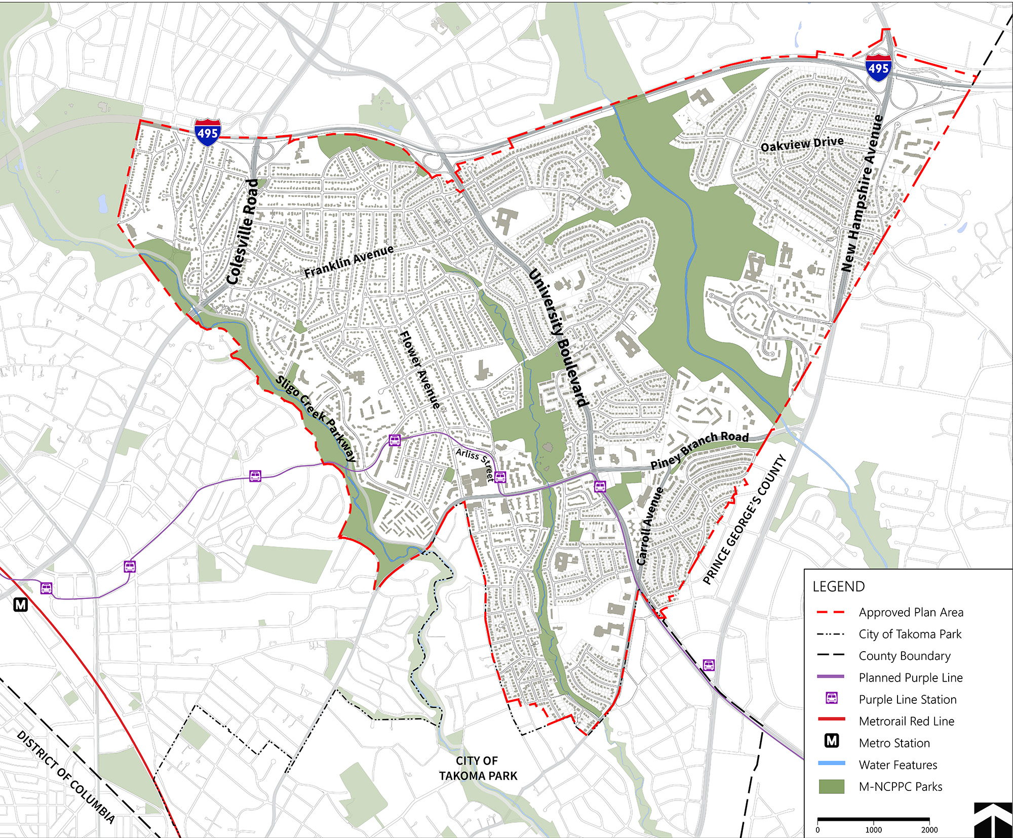
Following a review of the submitted testimony and live community testimony at the May 16 Planning Board meeting (watch it on demand), Planning Board members voted to extend the proposed plan boundary west to the Sligo Creek Stream Valley Park. The approved plan boundary extends from the Sligo Creek Stream Valley Park east to the Prince George’s County line inside the Capital Beltway (Interstate 495), extending south to the City of Takoma Park. The City of Takoma Park is not included in the approved Plan Area boundary (shown below).
View the Eastern Silver Spring Communities Plan Existing Conditions Report, Scope of Work and the Community Engagement Report as posted on May 9. The plan’s website includes Spanish versions of these documents.
More on the Plan Area
The boundary includes communities that are disconnected from larger urban and commercial centers like downtown Silver Spring, White Oak, and Takoma Langley Crossroads and captures large portions of the Sligo Creek Stream Valley Park, the Long Branch Stream Valley Park, and the Northwest Branch Stream Valley Park. The Plan Area also includes Long Branch’s commercial center, along with several residential neighborhoods, including multifamily and single-family properties, and many institutional properties.
The boundary includes sections of three Growth Corridors identified by the county’s General Plan, Thrive Montgomery 2050 – Colesville Road (US 29), University Boulevard (MD 193) and New Hampshire Avenue (MD 650). This plan is an opportunity to reimagine land uses and transportation options along these corridors.
“The Eastern Silver Spring Communities Plan seeks to advance ideas that invite investment, expand housing options and better connect those who live and spend time in the area to high-quality amenities and services,” said project lead Lauren Stamm. “We’re excited to collaborate with community members and other stakeholders to create a vision for this area.”
More About the Plan and How to Get Involved
The plan will amend sections of the 1996 Four Corners Sector Plan, the 2000 East Silver Spring Master Plan, the 2000 North and West Silver Spring Plan, the 2013 Long Branch Sector Plan and the 2014 White Oak Science Gateway Master Plan. The approval of the Scope of Work is one of the first steps in the master planning process and outlines the purpose of the plan, elements to explore, the boundary, and public engagement.
Montgomery Planning, also part of The M-NCPPC, will work with the communities in all areas of the Plan Area on each phase of the plan to inform the development of recommendations. Planning staff will conduct visioning sessions to get more community input, which will inform the development of the plan’s preliminary recommendations that will be presented to the Planning Board.
The community is encouraged to learn more about the plan by visiting its website and to sign up for an eletter to receive regular updates via email.