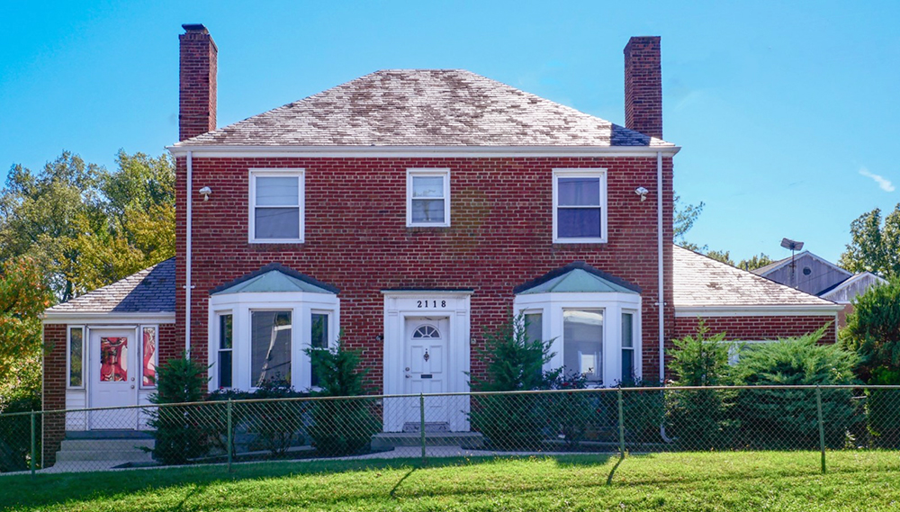
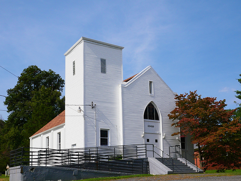
Update: Mapping A Mystery

Posted: by

Community input sheds light on Montgomery County history

By Kacy Rohn, in collaboration with Montgomery History

Over the summer, we published a blog post seeking input on an unanswered question about an abbreviation used on Martenet & Bond’s 1865 Map of Montgomery County. The map frequently used the letter “P” following individual’s names but didn’t indicate what that meant. Without a key to the map, we considered several meanings: could it be “place,” “principal,” “plantation,” or “pump?”  This was a mystery even to the original mapmaking company, S.J. Martenet & Co., whose records of the map’s production were lost in the Great Baltimore Fire of 1904.

In partnership with Montgomery History, we put out a call for suggestions and received nearly 100 … Continue reading

Mapping a Mystery: A Puzzle from the County’s Past

Posted: by

Seeking the community’s help to find answers

Written by Kacy Rohn, in collaboration with Montgomery History

Update: After receiving nearly 100 community submissions, see our best guess for the meaning of the letter “P” in this blog post.

Historic maps are key to understanding Montgomery County’s evolution. They reveal past social and economic systems, patterns of development and decline, and evolving transportation networks. Many of these maps have been closely studied for years, but they still hold mysteries about the county’s past. We are seeking input from county residents and historians to unravel a question about Martenet & Bond’s 1865 map of Montgomery County.

The map was published by Simon J. Martenet, a surveyor and civil engineer based … Continue reading

Recognizing History from Home: Exploring Clarksburg’s Past Through Montgomery County’s Field of Dreams

Posted: by

Written by Kacy Rohn with Dan Stouffer, M.A.T, M.S.Ed and the Seneca Valley High School Leadership Class

Montgomery Planning’s Historic Preservation Office staff have recently engaged with a Seneca Valley High School class seeking further historic recognition for Wims Meadow, also known as Wims Field of Dreams, in Montgomery Parks’ Little Bennett Regional Park. The site was a ballfield for the county’s African American baseball teams at a time when racial segregation restricted social and recreational outlets for Black residents. The field, which is accessible from Western Piedmont Trail in Clarksburg, is often mowed in the general outline of the regulation baseball field that once existed, and a wooden, rectangular backstop stands nearby. 

The history of land use and planning in Montgomery County

Posted: by

Montgomery County is one of the most desirable places to live and work in the United States. However, like many other places in the country, we are facing new and different issues and trends. This includes weak wage and job growth, persistent racial and economic inequities, demographic and cultural shifts, technological innovation, and climate change. Some of these issues have been reinforced, or even created, by our past public and private plans and actions.

As we finalize the update to the county’s General Plan, Thrive Montgomery 2050, it is important that we reexamine the county’s planning history to become a more equitable, sustainable, and resilient community. Let’s take a walk through the county’s past 245 years:

Montgomery County was … Continue reading

The Poor Farm Cemetery: A Dark and Overlooked Part of Our Past

Posted: by

Painful chapters of Montgomery County’s history played out at the Poor Farm and its associated cemetery south of Rockville along I-270. The Poor Farm was an almshouse surrounded by farm fields in use for nearly 200 years from as early as 1789 until the 1980s. Our county’s history is often difficult with regards to our historically vulnerable populations, like those that lived at the Poor Farm. Reading about these stories can be hard, but the Historic Preservation Program works to preserve and interpret these as part of our work to support a more equitable future for all of us. This work will be important with the expansion of I-270 around this historic site.

The Poor Farm’s difficult history

The … Continue reading

The Edward U. Taylor Elementary School

Posted: by

A once-segregated public school can teach future generations about an important chapter in county history

By: Kacy Rohn and John Liebertz

Locally designated African American historic sites around Montgomery County highlight the central role of African Americans in the story of the county and the nation. These sites include places where free and formerly enslaved African Americans lived, worked, worshipped, and buried their loved ones throughout the county.

Another site may soon be designated. Montgomery County Historic Preservation staff are considering whether the former Edward U. Taylor Elementary School in Boyds should be added to the county’s Master Plan for Historic Preservation. The recently approved and adopted MARC Rail Communities Sector Plan recognized the school as a neighborhood landmark … Continue reading

Preserving the Past: Cemetery Mystery Solved!

Posted: by

Planners use high tech tools to bring a historic headstone’s inscription back to life

By Brian Crane, PhD and Kacy Rohn

In the Planning Department, we talk a lot about the future. But much of our work is rooted in the past. We learn from history and we also help preserve it. Our county’s cemeteries are a treasure trove of information. Genealogists and history buffs love cemeteries for all the family history they contain, but time and nature pose challenges. Some historic gravestones have become so weathered, it’s almost impossible to read them.

New technologies have come to the rescue, offering ways to recover those lost inscriptions without damaging the stone. In November, someone contacted the county for help … Continue reading

Montgomery Modern Bus Tour 2017

Posted: by

Montgomery Modern Tour Day 2017 featured modernist buildings designed by the Silver Spring architecture firm Cohen, Haft & Associates. This event, held on Sunday, October 8, was our fourth annual Montgomery Modern Tour and was co-sponsored by AIA Potomac Valley and Docomomo DC.

Tour leader Clare Lise Kelly (right) of the Montgomery County Planning Department greets Tina Patterson, the newest Planning Board member, who joined the group on the bus.

We boarded the bus at the Bender Jewish Community Center of Greater Washington in Rockville.

Our first stop was The Hilltop at Seven Hills Lane, a 10-acre woodland neighborhood of 32 modernist houses designed by Cohen, Haft & Associates. Developed by Albert Brodsky and Edith Matthews, The Hilltop … Continue reading