Seeking the community’s help to find answers
Written by Kacy Rohn, in collaboration with Montgomery History
Update: After receiving nearly 100 community submissions, see our best guess for the meaning of the letter “P” in this blog post.
Historic maps are key to understanding Montgomery County’s evolution. They reveal past social and economic systems, patterns of development and decline, and evolving transportation networks. Many of these maps have been closely studied for years, but they still hold mysteries about the county’s past. We are seeking input from county residents and historians to unravel a question about Martenet & Bond’s 1865 map of Montgomery County.
The map was published by Simon J. Martenet, a surveyor and civil engineer based in Baltimore who produced detailed maps of Maryland counties. In looking closely at this map to understand a historic road alignment, Historic Preservation Office staff were drawn in by an unexplained abbreviation: the letter P.
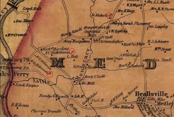
The abbreviation “P” appears frequently across the county, following local property owners’ names.
As we looked across the map, the letter P suddenly jumped out across the county. It appears in rural areas and in towns next to the names of presumed property owners. Without a key to the map, we considered several meanings: could it be “place,” “principal,” “plantation,” or “pump?” Intrigued, we contacted S.J. Martenet & Co., the original mapmaking company, for its insight. It turns out this question is a mystery even to the company, whose records of the map’s production were lost in the Great Baltimore Fire of 1904. This abbreviation was not used in Martenet’s other maps or included in a key, so the company doesn’t know its meaning.
With a growing mystery on our hands, we turned to the expert staff of Montgomery History. Librarian and Archivist Sarah Hedlund investigated but ended up at the same dead end: none of the possible meanings seem to make sense in all circumstances.
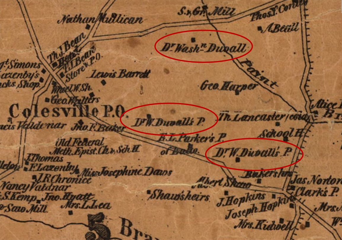
Near Colesville, Dr. Washington Duvall is identified with three sites, two of which are labeled with the abbreviation “P.”
We’re here to call on the expertise of county residents and historians who may hold the answer to this mystery – do you know what “P” represented?
We ask anyone who might know the answer (or have a good guess!) to reach out to us. We hope that together we can solve this puzzle and further our understanding of county history.

About the author
Kacy Rohn is a Historic Preservation Specialist at the Montgomery County Planning Department, part of the Maryland-National Capital Park and Planning Commission (M-NCPPC). Kacy conducts research and designation projects and leads historic preservation outreach and education programs. She completed a dual master’s program in Community Planning and Historic Preservation at the University of Maryland, College Park in 2017.
Nancy Lee Hutchin
On the Ordnance map of the Great Barrow area in UK, the Ps seem to indicate pumps, which is what a discussion of viewers settle on. But I don’t think that holds for MoCo. I’m wondering if there is a legal definition for a planatation – number of acres, production levels, etc. Then I would lean towards that. https://maps.nls.uk/view/101598952#zoom=5&lat=2738&lon=4820&layers=BT
Keith Bennett
Perhaps it represents ownership of a Parcel owned by them. The name includes apostrophe representing possession or ownership of land and the P is an abbreviation for “Parcel”.
Eileen McGuckian
Park Historian Mike Dwyer and I used to muse over this. We came to the conclusion that one of the entries (usually the largest size shown with that individual’s name) was the person’s home property, and that the others with the “p” and often with the individual’s name followed by apostrophe s (‘s) were other places owned by that individual. I think the p stands for “place.”
Looking up deeds for a sampling of these names and locations might bear some fruit.
You might check with historical societies and planners that are fortunate enough to have M&B maps for their jurisdictions.
Please remember to let us know what you learn!
Anne Bruder
I vote for Planter or Plantation. While it’s true that by 1865, most of Montgomery County’s plantations were really farms and most of the planters were actually farming, I suspect that the ring of “Richard Griffith, Jr. Planter” was the way to sound wealthy and powerful. If it was “planter” that would account for men in towns having the designation since they could still be a planter but not live on the plantation (which was sometimes the case). A plantation grew one crop for sale, which by the 1860s was becoming a questionable plan because from year to year a farmer couldn’t guarantee that the crop would grow successfully, or that the markets would pay sufficiently for the crop. I”m studying northeast Montgomery County at the moment and very conscious of what the farmers up there were growing, including Richard Griffith Jr.
Michael Ratcliffe
Interesting mystery. My thought is that “P” stands for “property.” There are a few instances in which a location is marked with one person’s name followed by “P” and another person’s name followed by “T,” which I presume stands for “tenant.” For example, in
Berry District 5, approximately halfway between Ashton and Brown’s Bridge, you’ll see a square with the notation “E. Thomas P” and “R.W. Sullivan T”. My assumption is that E. Thomas owned the property and RW Sullivan was the tenant. My understanding is that production of the maps was in part (maybe entirely) funded by subscriptions– that is, a person paid to have their name and property location indicated on the map. If that is correct, then perhaps only wealthier tenants paid to be listed on the map; hence the relatively small number of “Ts” on the map.
Katherine L. Rogers
I have wondered about this myself. I feel that I was told at some point that it stood for “Property”, meaning that the property was owned by an individual, but was not the main residence (Res.).
I look forward to hearing the solution to this!
Don Slater
I am wondering if it stands for “partnership.” Checking a couple of deeds might shed some light on that.
jim king
Primary, as in primary property owner within a partnership, perhaps?
Bonnie Bell
Could be short for Proprietor, particularly if it designates a place of business
Tony Cohen
Hmm. I believe “P” is for planter. If you look at those who show up in census records most have tremendous real and personal property holdings and are listed as “farmers” for occupation.
Deb McCormick
According to “MAPS OF THE TERRITORY INCLUDED WITHIN THE STATE OF MARYLAND, ESPECIALLY THE VICINITY OF BALTIMORE”, Johns Hopkins University Circulars Vol XII – No. 103, Published Baltimore, February, 1893, “As the population of Maryland increased it was natural that conditions should be constantly arising which called for more or less extensive and detailed private surveys. Such surveys have been made during the present century in great numbers. . . The most energetic promoter of private surveys throughout the entire State was Mr. Simon J. Martenet, who died in November 1892, at the age of sixty. He succeeded to the business of Thomas P. Chiffelle, City Surveyor, in 1855, and at once began the preparation of a new map of the state. This was carried on by counties. It was not based on triangulation of the area, but it nevertheless resulted in the collection of much new information. This survey was carried on between 1857 and 1965, when the first edition of the State map was published, although various county maps had been issued previously . . .”
Maybe the “P” means “private survey” and was used to indicate new information acquired by way of the private survey.
Duane Schmidt
Like Bonnie Bell above, my guess is proprietor, for the owner of the business property.
Susan C Soderberg
The “P’ stands for “proprietor.”
Tony Cohen
I seriously doubt that “P” stand for Proprietor. If you look at the inset for Rockville, you will not see anyone in the village with a “P” after their name. Since much of the town was full of businesses–which would have made proprietors of many of those listed-I doubt this logic carries through. Help me out here Eileen McGuckian!
If you then look at Brookeville names show “T” “Res” and “P”. I would assume, as others have previously mentioned, that “T” is likely tenant, “Res” is likely resident, which leaves “P” as either place or property, though all of these are properties. Both Elias J. HIll’s and Artemis Rigg’s names are possessive so their “P” likely means property which belongs to them. Others examples, such as Artemis Newlin, show him living in what we know now as the miller’s house at Newlin’s Mill. He owned the home and complex which bears his family name thought no T, P or Res is used. [Ownership of this property had been in dispute for years. Perhaps it wasnt settled at this point and none of the categories matched Newlin’s status there]
I am guessing whatever the terms are they were not used consistently. Perhaps multiple surveyors were working to gather the information and accounted for it unequally. Seeing that some “P” people lived in town centers, I now retract idea that “P” might stand for planters. I think it is the status of the building and “P” might represent property not occupied by its owner.
I would suggest looking at other town insets to determine the status of people we know about. Clarksburg, Poolesville anyone?
loc.gov/resource/g3843m.la000299/?r=0.429,0.07,0.523,0.214,0
Debbie
Proprietor can also mean “a holder of property”, not just someone who runs a business. However, that does not seem to be the case here because some of the entries have an apostrophe-s after the name, indicating possessive. I think the “P” might be “property” and was only used for those properties that were not occupied by their owners. Perhaps they were even vacant at the time, although it seems like there were a lot of them. The example of Dr. Duvall shows that one entry did not have a “P” – this could have been his residence and he could have owned the other properties. I would suggest that you research some of the deeds and tax records from this era for some of the names that have the “P”.
Patrick McHaffie
I think the P refers to proprietor, planter, property of, or property owner depending on circumstances. most likely most of these folks with the P after their names were farmers also known as planters in this region. It also was very common for farmers to subdivide their land holdings and pass them to their (principally male) children.
as maryland i believe was a “metes and bounds” cadastral state, there are no parcel boundaries shown – similar maps in u.s. public land survey states (township and range) further west would be showing detailed and fairly accurate property boundaries within 5 years.
an interesting date on this map considering the context, the end of slaveholding and the large number of recently freed slaves in montgomery county. almost 30% of the total population of the county was enslaved in 1860 just 5 years before this map was published, 78% of the african american population. in 1860 there were 770 slaveholders in the county.
Anna
Could the P be indicating the location of an active Physician? Especially given the Dr. in Dr. Duvall’s P.
The other Dr. Wash Duvall is maybe not a practicing physician? Elsewhere on the map they indicate Store and P.O. so it seems possible that they would use an initial to indicate a location of interest.
Anna
Or maybe P indicates a Plantation?
http://www.ijhssnet.com/journals/Vol_2_No_2_Special_Issue_January_2012/4.pdf
Kacy Rohn
Thank you, everyone, for your thoughtful comments so far! We’re taking everyone’s suggestions into consideration. You’ve given us a lot of great ideas to pursue.
Karl Franz
I am currently working on a project in Bedford County PA and came across a contemporaneous County map (E.L. Walker 1861) that has a notation in the key “P., Pro., or Prop.= Property”
https://www.loc.gov/resource/g3823b.la000707/
Ken Hawkins
I agree with Eileen McGuckian that the P likely denotes properties that were owned by the named individual but on which they did not live. Two examples in the Berry District near Four Corners and Silver Spring support this.
“Mrs. Emily Beale’s P” just to the left of the label for Burnt Mills P.O. This was Emily Truxton Beale (1798-1885)’s country place, purchased by her in 1850 and held by the family in a trust until 1903. Her primary residence at the time of the Martenet map (1865) was in the District (the Bloomingdale estate north of the U.S. Capitol), making her property on this map her secondary property (thus, P).
Another example are the properties of F.P. Blair, Sr. His primary residence was Silver Spring, located just west of the Seventh Street turnpike (now Georgia Ave) after it left the District. Another of his properties is noted to the northeast, near Sligo Creek, and marked as “F.P. Blair’s P.” He bought the latter property from the Clark family but did not live there.