Posted: by ...

Community input sheds light on Montgomery County history

By Kacy Rohn, in collaboration with Montgomery History

Over the summer, we published a blog post seeking input on an unanswered question about an abbreviation used on Martenet & Bond’s 1865 Map of Montgomery County. The map frequently used the letter “P” following individual’s names but didn’t indicate what that meant. Without a key to the map, we considered several meanings: could it be “place,” “principal,” “plantation,” or “pump?”  This was a mystery even to the original mapmaking company, S.J. Martenet & Co., whose records of the map’s production were lost in the Great Baltimore Fire of 1904.

In partnership with Montgomery History, we put out a call for suggestions and received nearly 100 … Continue reading

Posted: by ...

By Sarah Reddinger, Vice President of Community Development, Habitat for Humanity Metro Maryland

In September 2020, Habitat for Humanity Metro Maryland was approached by the City of Takoma Park to partner on the redevelopment of a single-family home into an affordable homeownership opportunity. The home happened to be located in a zone that allowed for duplexes, which is rare in Montgomery County, so we saw this as the perfect chance to demonstrate how duplexes can fit into existing single-family neighborhoods while also driving down the cost per unit. The City assigned its Right to Purchase to Habitat and generously provided $200,000 to from its Housing Reserve Fund to help subsidize the project. And so, the Garland Ave Duplex … Continue reading

Posted: by ...

By Casey Anderson and Jai Cole

Parks, recreation, and open space are the motherhood and apple pie of land-use planning and local government, with just about everyone agreeing on their value and appeal. But if you’ve ever been to a public meeting about a dog park or skateboard facility (or even a soccer field) you know that the consensus starts to break down when decisions are made about how parks and public spaces will be used and where the amenities to support them will be located.

Montgomery County has long been a leader in adopting forward-thinking policies to preserve land for parks, recreation, agriculture, and resource conservation. Thrive Montgomery 2050 builds on this legacy, partly by recommitting to state-of-the-practice … Continue reading

Posted: by ...

Written by Todd Fawley-King, Lisa Govoni

During debates and testimony about the proposed Attainable Housing Strategy, multiple participants have wondered about the housing landscape following the COVID-19 pandemic and the need to allow for more housing in established single-family zones. Will people want to live in denser housing? Will we be able to satisfy our housing needs with the empty units sitting in our downtowns? Certainly the headlines from newspapers like The New York Times and The Washington Post gave that impression: “America’s biggest cities were already losing their allure;” “The Pandemic is making people reconsider city living.” These newspapers even verged on fearmongering: “Which cities are renters fleeing, and where are they going?;” “They can’t leave the Bay … Continue reading

Posted: by ...

This blog was originally posted on August 4, 2021 and has been updated to add in research and information from the Montgomery Planning’s Historic Preservation and Research and Strategic Projects offices about the equity issues involved in examining Montgomery County’s industrial land uses.

Introduction

The COVID-19 pandemic’s increase of e-commerce and package fulfillment, falling industrial vacancy rates, and the surge in development of industrial space regionally and nationwide have communities rethinking the amount of industrial land they need. Industrial clusters are often targeted for redevelopment when they are near transit facilities because they are less valuable per acre than higher density and/or higher rent, office, retail, and multifamily properties. Additionally, jurisdictions that are in the core of metropolitan areas … Continue reading

Posted: by ...

A conversation with Research Planner Nicholas Holdzkom on the Montgomery County Mixed-use Development Study

By Nicholas Holdzkom and Karen Blyton

You may have noticed new apartment buildings in your area that are being built on top of grocery stores, restaurants, or other retailers.  Montgomery County has allowed mixed-use development in buildings around activity centers for many years with the goal of creating interactive streets, providing meaningful public spaces, and creating communities where people can live, work, shop, and play within a given neighborhood.  Numerous studies show that mixed-use districts generate higher real estate value, reduced vehicle miles traveled, and higher transit ridership. These mixed-use properties, which are common in downtown Silver Spring and Bethesda, have accounted for nearly 50 … Continue reading

Posted: by ...

Part 1 of this blog series used data from the Opportunity Insights project to show that children raised in Montgomery County were able to move further up the economic ladder than children growing up in other parts of the United States. However, the blog also showed that there is a strong correlation between economic mobility   and race and ethnicity, and it suggested that, depending on how the population is divided, the prosperity of places does not always coincide with the prosperity of the people living in them. This blog explores these issues in more detail by focusing on the county’s neighborhoods and shows that economic mobility across the County and within neighborhoods differs significantly based on race and ethnicity.

Continue reading

Posted: by ...

A conversation with Montgomery Planning’s “equity data team” on the award-winning Equity Focus Areas analysis and story map

By Pamela Zorich, Jay Mukherjee, and Karen Blyton

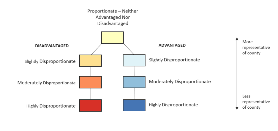
Montgomery Planning is committed to eliminating racial inequities and creating equitable communities within Montgomery County. One key part of this work is the Equity Focus Areas (EFA) analysis, created by our Equity Data Team. The team recently won a 2021 Data Viz Award from the Association of Public Data Users for their story map created to illustrate their findings.

We sat down with two members of the Equity Data Team, Pamela Zorich and Jay Mukherjee, to discuss their work on this analysis, how it may help create a more equitable Montgomery County, … Continue reading

Posted: by ...

Montgomery County Planning works to create thriving places across the county. This goal is reflected in our proposed General Plan update, Thrive Montgomery 2050, master plans, functional plans, and other special studies.

But how do we know if a place is indeed thriving?  We often use publicly available data from agencies like the U.S. Census Bureau and the U.S. Bureau of Labor Statistics to analyze shifts in key indicators of an area’s economic vitality.

Now let’s zoom in on the map and ask a deeper question: do thriving neighborhoods help the people living in them to thrive? Put another way, do neighborhoods thrive because the people living in them improved their economic status, or because people of higher … Continue reading

Posted: by ...

Seeking the community’s help to find answers

Written by Kacy Rohn, in collaboration with Montgomery History

Update: After receiving nearly 100 community submissions, see our best guess for the meaning of the letter “P” in this blog post.

Historic maps are key to understanding Montgomery County’s evolution. They reveal past social and economic systems, patterns of development and decline, and evolving transportation networks. Many of these maps have been closely studied for years, but they still hold mysteries about the county’s past. We are seeking input from county residents and historians to unravel a question about Martenet & Bond’s 1865 map of Montgomery County.

The map was published by Simon J. Martenet, a surveyor and civil engineer based … Continue reading