Germantown Employment Area
Approved and Adopted 2009
The Germantown Employment Area Sector Plan establishes a vision that will transform Germantown’s central employment corridor into a vibrant town center with mixed-use districts surrounding the downtown. Germantown is planned to become the center of business and community life in upper Montgomery County.
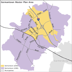
This Sector Plan amends about 2,400 acres of the 13,000-acre Germantown Master Plan, approved in 1989. View the approved and adopted 2009 plan and appendix.
For most areas outside the Sector Plan (see map, right), the 1989 Master Plan remains the guiding document. See the MARC Rail Communities Plan for changes to the plan near the train station and the Germantown Plan for the Town Sector Zone for a small area near Father Hurley Boulevard and Wisteria Drive.
Related Documents
- Sectional Map Amendment G-887 (Resolution No. 16-1349) (May 18, 2010)
- Germantown Design Guidelines (June 2010)
- Sector Plan Appendix (February 2009)
- See also the Germantown Planning Library which contains background on the creation of this Sector Plan.
Approved and adopted in October 2009, the plan covers 2,400 acres and creates a vision for mixed-use communities served by MARC commuter rail and the future Corridor Cities Transitway. New zoning tools and design guidelines will help new development and redevelopment in Germantown become walkable, sustainable, and linked to the history and cultural facilities of the community.
Development projects in this plan area
Plan Vision
See the progress in Germantown’s Town Center since the plan was approved in this video excerpt from our Montgomery Plans cable show.
The plan recommends ways to create or enhance:
- a vibrant economic core
- employment centers
- communities organized around transit
- connections to Germantown’s greenbelt and stream valley parks
- design quality and sustainability in the public and private realms
- connections to cultural, historic, and civic facilities such as Montgomery College, the BlackRock Center for the Arts, the Germantown library, and a greenbelt of parks
The plan’s zoning changes are summarized in a Sectional Map Amendment sheet. Or view interactive zoning maps, following these instructions:
- click on your area number to zoom to your property
- click on the existing and SMA buttons to see the proposed zoning changes
- click on the hand to move to move another area
- click on the pencil to draw or write notes
- click on the print button at any time

See the future Town Center in this 3-D video, which illustrates the plan density on the westside of I-270. The Town Center will be transformed from a one- and two-story place into a high-rise urban center clustered.
Timeline
- 2010: The Sectional Map Amendment is prepared and approved in order to begin implementation of the Sector Plan.
- 2009: The new Sector Plan, covering the area of the Germantown Master Plan near the now-cancelled Corridor Cities Transitway, proposes to emphasize growth and development of Germantown’s Transit/Employment Corridor to boost the community’s economic base, enhance the Town Center, and help residents find jobs closer to home. The parts of the 1989 Plan outside of the Sector Plan boundary remain in effect.
- 1989: The revised Germantown Master Plan refines the vision of the town, which grew to about 35,000 residents. As common for new towns, the residential section of Germantown grew much faster than the employment portion. Thus, the originally planned residential areas of the community are nearing capacity, while the planned employment lags.
- 1974: The Germantown Master Plan provides the blueprint for a new town, one of several Corridor Cities proposed along I-270
- 1970: Germantown continues to be identified as a farming town with a population of about 2,000
- 1964: Germantown identified as one of the I-270 Corridor Cities in the General Plan
The Master Plan Process
Planners develop master and sector plans to create a framework for each community designed to last 15 to 20 years. The framework helps planners and policymakers – such as the Planning Board and County Council – make policy and decide on proposed development. Each plan includes an inventory of land uses and an analysis of zoning, transportation, community facilities, environmental assets, and historic structures, among many other elements.
The 2009 Plan was guided by Montgomery County’s previous General Plan, originally approved in 1964, which defined the land use concept “Wedges and Corridors,” a regional plan that envisioned growth corridors radiating from Washington, D.C., like the spokes of a wheel. In between each spoke, wedges of open space, farmland, and residential areas prevail. Areas along the corridors – such as Germantown – provide opportunities for vibrant, compact, walkable communities. A new general plan, Thrive Montgomery 2050, was approved in 2022 and builds on these ideas with increased emphasis on equity and social justice, better connectivity, accessible housing, a mix of uses, and sustainability.