On December 18, 2013, the Maryland- National Capital Park and Planning Commission adopted the Planning Board Draft of the Countywide Transit Corridors Functional Master Plan, as modified by the County Council on November 25, 2013.
- Approved and adopted Countywide Transit Corridors Functional Master Plan (pdf, 35MB)
- Resolution for Adopted Plan (pdf, 15MB)
- View the online appendix
Purpose
This Plan provides enhanced opportunities for travel by transit to support Montgomery County’s economic development and mobility goals in an environmentally sustainable way, and in a way that preserves our existing communities. As a Functional Master Plan, it makes no changes to current planned land use or zoning, but recommends changes and additions to the transportation network that are needed to serve the County’s most densely developed areas, areas planned for redevelopment, and areas planned for new dense development.
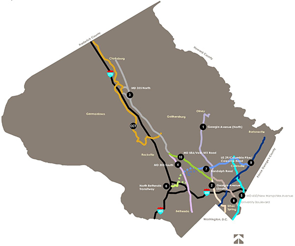
Transit Corridor Network Map
This map below shows the 11 corridors that are included in the Countywide Transit Corridor Functional Master Plan.
|
Corridor Number
|
Corridor
|
From
|
To
|
Route Length
(miles) |
Number of Stations
|
|---|---|---|---|---|---|
|
Recommended Corridors
| |||||
| 1 | Georgia Avenue North | Montgomery General Hospital | Wheaton Metrorail station | 9.6 | 13 |
| 2 | Georgia Avenue South | Wheaton Metrorail Station | District of Columbia line | 3.9 | 8 |
| 3 | MD 355 North | Redgrave Place | Rockville Metrorail station | 15.3 | 24 |
| 4 | MD 355 South | Rockville Metrorail Station | District of Columbia line | 7.8 | 13 |
| 5 | New Hampshire Avenue | Colesville Park & Ride | District of Columbia line | 8.5 | 12 |
| 6 | North Bethesda Transitway | White Flint Metrorail Station | Montgomery Mall Transit Center | 2.7 | 8 |
| 7 | Randolph Road | White Flint Metrorail Station | US 29 | 10.1 | 11 |
| 8 | University Boulevard | Wheaton Metrorail Station | Takoma/Langley Transit Center | 5.5 | 9 |
| 9 | US 29 | Burtonsville Park & Ride | District of Columbia line | 12.3 | 11 |
| 10 | Veirs Mill Road | Rockville Metrorail Station | Wheaton Metrorail Station | 6.2 | 11 |
| CCT | Corridor City Transitway | Shady Grove Metro Station | Frederick County Line | 20.1 | 19 |
| Overall System Total | 102 | 118* | |||
