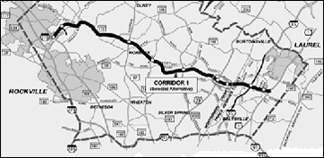
The Intercounty Connector (ICC) connects I-370 near the Shady Grove Metro Station with Route 1 between Beltsville and Laurel, spanning 18 miles across central Montgomery County and northern Prince George’s county. The Maryland State Highway Administration (SHA) led the planning, design and construction of the toll highway.
SHA divided highway construction into five parts, called contracts. The Montgomery County contracts include:
- Contract A: I-370 east to Georgia Avenue (MD 97).
- Contract B: Georgia Avenue (MD 97) east to Colesville Road (US 29)
- Contract C: Colesville Road (US 29) to I-95 within Prince George’s County
Why Build the ICC?
In the 1950s, the National Capital Planning Commission (NCPC) proposed an outer-ring highway around the Beltway. While planners and policy-makers later dropped the idea of a complete outer beltway, they retained the ICC between I-270 and US 1 as a critical link for the region’s transportation network.
The ICC:
- Improves mobility in the developed portions of central Montgomery and northern Prince George’s counties
- Boosts economic development in technology areas such as the I-270 corridor, the BWI Airport development area and the U.S. 1 corridor
- Creates more interaction between communities
- Provides better access to government and community services
- Improves safety on local roads, now accommodating high volumes of traffic
Montgomery County Planning Board’s Role
The Montgomery County Planning Board helped the state plan and implement the ICC, which had been part of county master plans for decades. With both its Department of Parks and Planning Department, the board considered issues such as:
- Parkland transfer. The highway’s route crosses through some county parkland that was transferred to the state. In return, the board received replacement park parcels that provide equivalent natural resource value and a replacement ratio of 8 acres of for each acre transferred to the state.
- Facilitating and advising on highway design elements, with particular focus on environmental reviews of the county’s Upper Rock Creek and Upper Paint Branch Special Protection Areas (SPAs).
- The cross-county bike route envisioned in county plans to run parallel with the highway
The board and its staff negotiated and participated in stewardship projects related to the highway construction, such as wetlands mitigation, reforestation, invasive species management, relocation of species of interest (such as box turtles) and improving county park facilities.
The Planning Board agreed to transfer about 44 acres of county parkland in the path of the proposed ICC to SHA. As part of the Record of Decision that spells out the particulars of the project, state highway officials will provide about 8.5 acres of replacement park property for every acre of parkland lost.
Planners also worked on the ICC hiker-biker trail that runs along the highway. In addition to the Hiker-Biker Trail, another upcoming stewardship project which is being designed and constructed by the Maryland State Highway Administration (SHA), called the Lake Frank Trail is in the planning stages.
Staff Briefings
Staff updated the Planning Board on the status of the ICC design and construction status, with special attention given to parkland and stewardship issues. Each file is a PDF version of the transportation planning division’s staff report to the board.
Status of the ICC roadway project
| ENGINEERING, DESIGN AND CONSTRUCTION |
|---|
| Status Report # 21 (June 10, 2010) |
| Status Report # 20 (March 25th, 2010) [PDF] |
Mitigation and stewardship projects
| DATE | STAFF REPORT |
|---|---|
| 07/23/09 | Mandatory Referral #09901-MTA-1 for Project NW-160/NW-170 [PDF] |
| 01/17/08 | |
| 07/13/06 |
Mandatory referral
| DATE | STAFF REPORT |
|---|---|
| 07/13/06 |
ICC planning (leading up to the SHA record of decision)
| DATE | STAFF REPORT |
|---|---|
| 09/15/05 | |
| 07/28/05 | |
| 02/03/05 | |
| 01/13/05 | |
| 07/15/04 | |
| 06/03/04 | |
| 03/04/04 | |
| 01/22/04 |