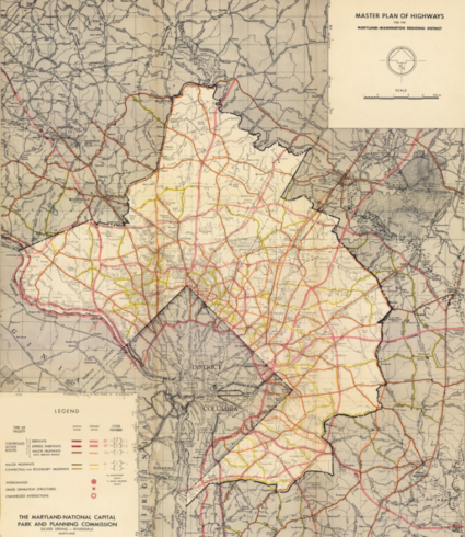
The first bi-county Master Plan of Highways for Montgomery County and Prince George’s County was prepared in 1931, shortly after the creation of the Maryland-National Capital Park and Planning Commission in 1927. The last comprehensive update to the Master Plan of Highways was approved and adopted in 1955. The 1955 plan covered only the eastern one-third of Montgomery County within the Maryland-Washington Regional District as it existed at the time – roughly the area east of Georgia Avenue, east and south of the City of Rockville and the Potomac area southeast of Glen Road (Figure 1).
In 1956, the M-NCPPC planning area within Montgomery County was expanded to include all of the county (except for municipalities with independent planning authority). A draft Master Plan of Highways for the entire area of both Montgomery and Prince George’s Counties was proposed in 1967, but the process was never completed. Since then, the master planning functions for each county have been separated. The amended plan currently is referred to as the Master Plan of Highways and Transitways within Montgomery County.
The need and authority for the creation and adoption of a Master Plan of Highways was affirmed in Volume 642, Section 67 of the Laws of Maryland, 1959 (page 1255). The purpose of the Master Plan of Highways and Transitways is to give the Maryland-National Capital Park and Planning Commission the responsibility to master plan the region’s major roadways regarding location, character, grade and extent. For Montgomery County, this planning effort includes the area type, street type classification and design standards consistent with the Montgomery County Complete Streets Design Guide and the Montgomery County Road Code, including the planned number of travel lanes, target speeds, transit and high occupancy vehicle (HOV) accommodations, pedestrian and bicycle accommodations, master planned right-of-way widths, planned interchanges, and planned transit stations.
The area master plans and sector plans that have been approved and adopted by the Montgomery County Council since 1955 have been amended to the Master Plan of Highways and Transitways, as have the many limited functional master plans and Master Plan of Highways Amendments. Maps of the Master Plan of Highways (and Transitways) approved roads and transitways networks for the whole county were published in 1986, 1992, 2005 and 2010 as reference documents derived from all previously approved plans and amendments, rather than as stand-alone approved and adopted plans. These previous plans can be accessed from the Previous Master Plans section at the bottom of this page.