The Bethesda Downtown Plan recognizes the importance of urban green spaces as a network and ecosystem of parks, street trees, tree clusters, green roofs, planted areas (including stormwater management systems), streams and community gardens. These spaces promote both physical and psychological wellbeing and provide connections to link existing and proposed green spaces both within Bethesda and beyond. The plan identifies the goal of increasing the overall tree canopy, expanding green corridors by linking green streets, green space and green roofs and reducing the urban heat island effect.
The plan makes the following recommendations:
- Supplement tree planting along streets and public space to achieve a minimum of 50 percent overall canopy cover.
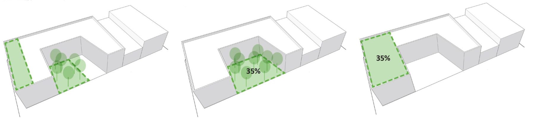
- On private property, provide a minimum of 35 percent of the site as green cover, which may include singularly or in combination an intensive green roof or tree canopy cover.
Tree Canopy
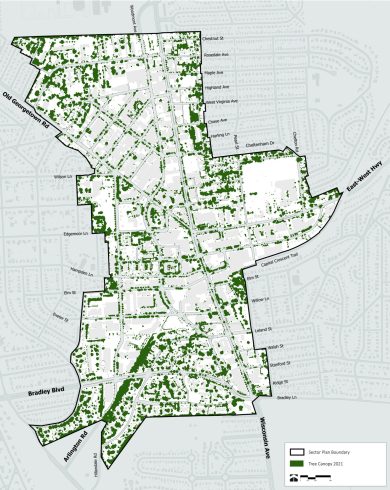
Tree canopy is defined as vegetation 8 feet or taller. To measure the existing tree canopy, a third-party consultant uses aerial reconnaissance infrared and LiDAR (Light Detection and Ranging) imagery to identify and map vegetation. In 2021, Bethesda had a tree canopy of approximately 20%.
In 2021, a higher LiDAR standard was introduced that captures 8 samples per square meter, compared to the previous standard of 4 samples per square meter. The higher standard is able to better capture smaller saplings that were previously not included. Therefore, the overall tree canopy capture for any given area is higher than it would be if the older LiDAR was used, simply due to the better resolution of the newer technology. Consequently, the LiDAR imagery from 2021 can not be compared with LiDAR data taken in previous years. Future LiDAR data, expected in the near future, will use the higher standard and will be comparable with the 2021 imagery. View information on Bethesda’s tree canopy.
Green Cover
New construction in Downtown Bethesda is required to meet 35 percent green cover on their site. There are a variety of options that can be used to meet this requirement, and they can be used in combination or one may be used to meet the requirement in its entirety. An applicant can meet the 35% green cover requirement by providing:
Green Cover Compliance by Development
| Site | Month and Year of Approved Resolution | Green Cover Provided (Percentage) | Total Green Cover Provided (square feet) | Green Roof (square feet) | Green Cover Provided as Green Roof (percentage) |
|---|---|---|---|---|---|
| Marriott (Wisconsin Avenue at SW Intersection with Norfolk Avenue) | December 2017 | 38.6%* | 29,264 | 29,264 | 100% |
| 7359 Wisconsin Avenue | February 2018 | 35% | 12,734 | 12,734 | 100% |
| 8000 Wisconsin Avenue | May 2018 | 35% | 10,229 | 10,229 | 100% |
| ZOM Bethesda (East Side of Arlington Road between Moorland Lane and Edgemoor Lane) | July 2018 | 35% | 19,572* | 19,572 | 100% |
| Edgemont at Bethesda II (Edgemoor Lane at the Corner of Woodmont Avenue) | September 2018 | 30.60% | *15,970 | 10,643 | 67% |
| Artery Plaza- E Amendment (Northwest Quadrant of the Intersection of Wisconsin Avenue and Bethesda Avenue) | October 2018 | 39% | 4,363 | 1,038 | 24% |
| 7607 Old Georgetown Road | January 2019 | 35% | 4,833* | 3,223 | 67% |
| Metro Towers (Northwest Quadrant of the Intersection of Wisconsin Avenue and Elm Street) | July 2019 | 32.5%* | 7,957* | 7,957* | 100% |
| 4915 Auburn Avenue | November 2019 | 35% | 9,822* | 5,652 | 58% |
| St. Elmo (Southeast Side of St. Elmo Avenue, 300’ Southwest of Norfolk Avenue) | March 2020 | 27% | 7,026 | 6,707 | 95% |
| 7000 Wisconsin Avenue | April 2020 | 35% | 7,017 | 3,931* | 56% |
| 4702 West Virginia Avenue | May 2020 | 35% | *3,071 | 2,792 | 91% |
| 8015 Old Georgetown Road | July 2020 | 35% | *27,977 | *7,572 | 27% |
| 4824 Edgemoor Lane | March 2021 | 35% | 2,695 | 2,160 | 80% |
| Hampden East (on the Block of East Lane Between Montgomery Lane and Hampden Lane) | July 2021 | 35% | 10,700 | 10,700 | 100% |
| Avondale (Southeast Quadrant of the Intersection of Avondale Street and Wisconsin Avenue) | September 2021 | 35% | 5,675 | 4,829 | 85% |
| 4725 Cheltenham Drive | February 2022 | 35% | *3,939 | 3,777 | 96% |
| 2 Bethesda Metro Center- E Amendment (Located on the Northeast Quadrant of Woodmont Avenue and Montgomery Lane) | March 2022 | 15.70% | 8,500 | 4,708 | 55% |
| Claiborne (Located in the East Quadrant of the Intersection of Auburn Avenue and Norfolk Avenue) | September 2022 | 35% | 4,686 | 4,114 | 88% |
| 4901 Battery Lane | December 2022 | 35% | 29,746 | 15,434 | 52% |
| Battery District Site C (Located on Battery Lane Approximately 350’ West of the Woodmont Avenue Intersection) | February 2023 | *45% | *57,453 | 27,973 | 49% |
| 7340 Wisconsin Avenue | April 2023 | 35% | *6,532 | 4,717 | 72% |