This piece was originally published on brookings.edu on February 16, 2022.
By Jesse Cohn McGowan (Transportation Planner Coordinator), Lauren Pepe (Senior Planning Associate), and Juan Jose Castro Cerdes (Senior Planning Associate), Montgomery County Planning Department
Transit has the potential to connect people to places in a sustainable, affordable manner—but only if riders can access it. Transportation planning must take into account not only where transit services are located, but how people traverse the built environment to access such services. Lower-income, majority-minority neighborhoods often lack the basic infrastructure for walking (such as sidewalks and crosswalks) and are more likely to have had their neighborhoods cut off by highways—resulting in disproportionate numbers of pedestrian crashes, injuries, and fatalities in these areas compared to other communities. Given that residents from these same neighborhoods are also most likely to rely on public transportation to get to work, it’s clear that deep spatial inequities exist in both transit access and safety.
As members of the Montgomery County Planning Department in Maryland, we have a front-row seat to these challenges during the development of a new transit line: the Purple Line light rail, which will connect Montgomery County to Prince George’s County. Below, we highlight our efforts to study and tackle pedestrian access as a fundamental equity issue across the communities the rail line will serve.
A data-driven approach to understanding disparities in pedestrian safety
When the Purple Line opens in 2026, most passengers will arrive at stations by foot, bus, bicycle, or train, as the stations were intentionally designed without new parking to promote walkable, transit-oriented development. Comfortable pedestrian access to the stations is therefore a top priority for our organization, with a goal to ensure that all residents benefit from this significant new transportation investment.

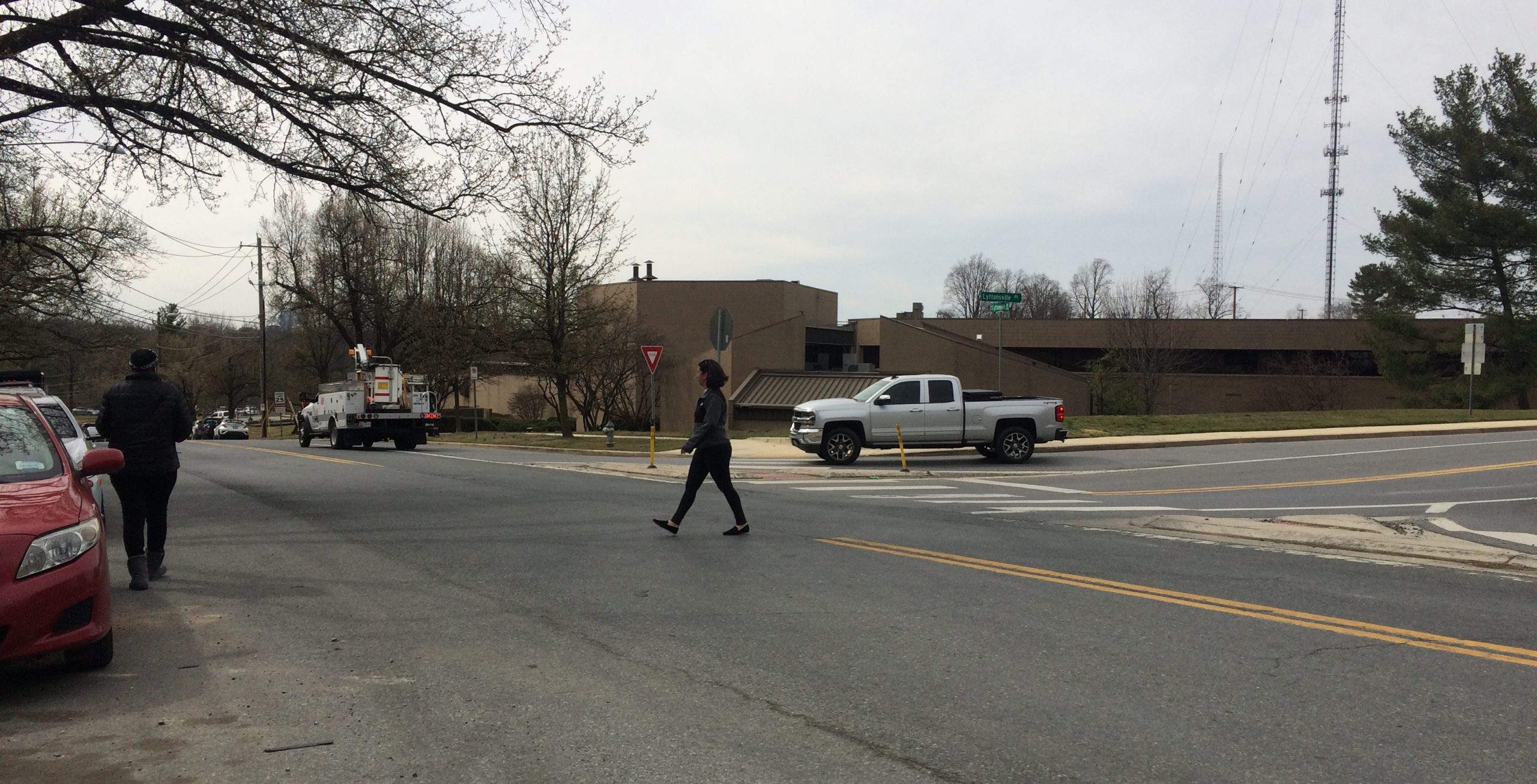
There are no marked crosswalks across Lyttonsville Road at Brookfield Road.
Unfortunately, comfortable pedestrian access to many of the planned Purple Line stations is lacking—particularly in neighborhoods with spotty walking infrastructure and overlapping equity concerns. For instance, there are no marked crosswalks across Lyttonsville Road near the Lyttonsville station (Image 1)—a historically Black community located between Bethesda and Silver Spring that includes one of the county’s few industrial districts inside the Capital Beltway.
To quantify “comfortable” pedestrian access, identify disparities in access across places, and recommend improvements to the walking environment, we developed the Purple Line Pedestrian Connectivity Report. For the 11 Purple Line light rail stations serving Montgomery County, we assigned comfort levels to each pedestrian pathway and crossing using our department’s Pedestrian Level of Comfort tool. The tool evaluates the pedestrian network using factors such as sidewalk width, speed limit, or crosswalk type, and assigns a score ranging from “very comfortable” (Comfort Level 1) to “undesirable” (Comfort Level 4). We then used these scores to determine how much of each home-to-station pedestrian trip was “comfortable” (Comfort Level 1 or 2) and developed an overall comfortable connectivity score for each station based on all the trips to that station.
Our results reveal that, in general, stations located in downtowns (such as Bethesda and Silver Spring) already have high comfortable connectivity to the proposed Purple Line stations. In contrast, proposed Purple Line stations located on major highways with higher posted speed limits are currently not well connected to the surrounding communities, indicating the need for pedestrian improvements in these areas to provide a comparable transit experience.
Based on these results, we made a series of recommendations to make walking to Purple Line stations more comfortable. These included short-term improvements (such as reducing speed limits and installing crosswalks) as well as medium- to long-term improvements (such as the installation of wider sidewalks and sidewalk buffers). Figure 1 highlights the connectivity improvement for each station if all recommendations from our report are implemented—illustrating that there is not one a one-size-fits-all solution to improving station access, and that unique interventions will be required for each place.
Figure 1. Pedestrian Connectivity by Station at Purple Line Opening and with Additional Recommendations
This chart displays pedestrian connectivity at Purple Line stations in Montgomery County under three different scenarios: 1) connectivity when the Purple Line opens absent implementation of recommendations (maroon); 2) connectivity if recommended short-term improvements are implemented (pink); and 3) connectivity if medium- and long-term improvements are implemented (gray). While some stations, such as the Silver Spring Transit Center, already have high pedestrian connectivity without interventions, others, such as the Takoma-Langley Transit Center, have very limited pedestrian connectivity.
Considering equity when improving walkability
While our recommendations aspire to increase connectivity in all station areas, we particularly aim to improve connectivity in the least-connected areas. For instance, the three stations that would have the lowest overall connectivity at the Purple Line’s opening absent improvements (Piney Branch Road, Takoma-Langley Transit Center, and Woodside) intersect with the Metropolitan Washington Council of Governments’ Equity Emphasis Areas, meaning they have significant concentrations of low-income and/or minority populations. Moreover, many of the stations located in Equity Emphasis Areas require the additional implementation of our medium- to long-term recommendations to experience substantial connectivity benefits.
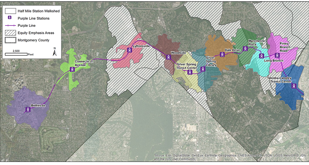
Figure 2. Purple Line Corridor Half Mile Station-Area Walksheds

This map displays the Purple Line stations in Montgomery County (marked with purple icons). The colorful shapes around each station represent a half-mile walking distance from the station, and the hatched areas are Equity Emphasis Areas as designated by MWCOG.
Take, for example, the Takoma-Langley Transit Center. This future Purple Line station is located along the border of Montgomery and Prince George’s counties, and faces considerable equity challenges. There are 1,100 residential units within a half-mile walk to the station; 86% of residents in this walkshed are people of color, and the median household income is $25,000 lower than the surrounding counties. Situated at the intersection of major arterials—University Boulevard and New Hampshire Avenue—the Takoma-Langley Transit Center is surrounded by high-speed, high-volume roadways with limited pedestrian infrastructure. If the Purple Line opens absent suggested improvements, the station would also have nearly the lowest comfortable connectivity among stations in Montgomery County.
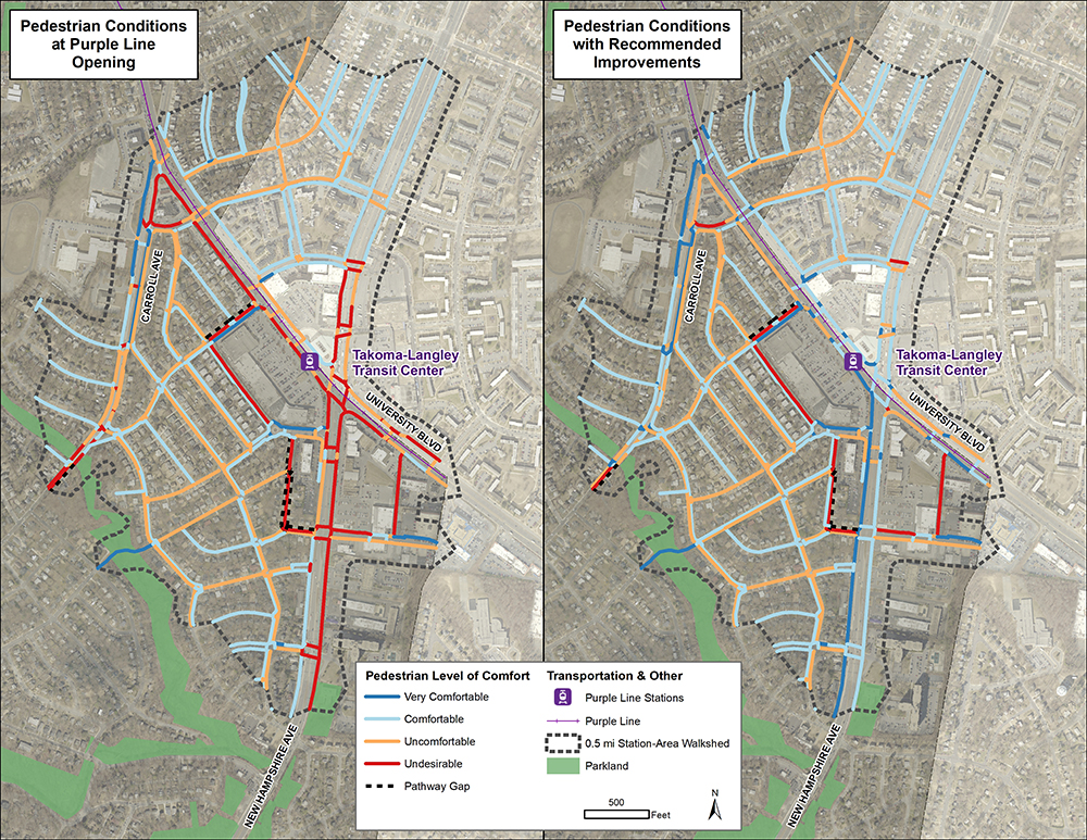
However, the station could see a 61% increase in comfortable connectivity if our report’s recommendations are implemented—a 41% improvement from short-term recommendations (such as reducing posted speed limits on adjacent streets, providing automatic speed enforcement, and installing high-visibility crosswalks) and a further 21% increase from medium- to long term recommendations (such as improving sidewalks, adding a buffer, and constructing a two-way, separated bike lane on west side of New Hampshire Avenue). Implementation of these recommendations would result in more equitable pedestrian access and allow the average transit user at the Takoma-Langley Transit Center to have as comfortable experience as those walking to the Bethesda station.

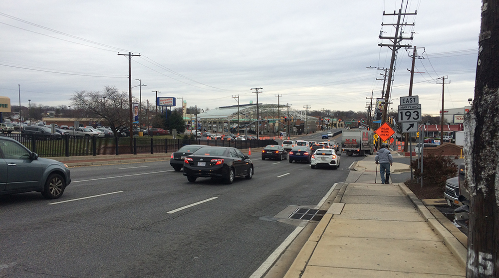
New Hampshire Avenue has no buffer between pedestrians on the sidewalk and the 35-mph roadway (source: Montgomery Planning-M-NCPPC).
Figure 3. Pedestrian Connectivity at the Takoma-Langley Transit Center at Station Opening and with Targeted Improvements

The map shows the difference in comfortable connectivity at the Takoma-Langley Transit Center between if the Purple Line opens without improvements and with the recommended pedestrian improvements, including speed limit reductions, new bikeways, high-visibility crosswalks, and widened space for pedestrians.
Make pedestrian access part of the transit planning process
If the Purple Line’s stations are constructed without additional pedestrian improvements, five of them will have less than 50% connectivity when transit service begins—a missed opportunity to improve transit equity and access for areas with high concentrations of low-income residents and people of color. The Purple Line Pedestrian Connectivity Report found that implementing targeted recommendations can increase connectivity for every station on the Purple Line and can provide significant improvements for the eight stations located in Equity Emphasis Areas—particularly, those with the lowest overall connectivity at opening.
Pedestrian access to transit should not be an afterthought—it should be an integral part of the transit planning and implementation process. While our report outlines improvements that would increase comfortable connectivity and access to transit, the Purple Line project will not in itself include these much-needed improvements. Fortunately, Montgomery County is funding some improvements separately through its Bicycle and Pedestrian Priority Areas program, including new sidewalk connections, Americans with Disabilities Act upgrades, and bikeway projects. These investments are a positive step toward achieving comfortable, equitable pedestrian access to the Purple Line.
Robert Smythe
This looks very much to me like an after-the-fact catch-up effort to deal with problems that should have been raised and resolved BEFORE the Purple Line was approved. As is usual in Montgomery County, pedestrians come last in the planning process.