Note: This archive page is no longer updated and may contain out-of-date information.

Here’s some inside baseball for you—planners love maps. Mention letraset and T-squares to older planners and they’ll start squirting tears for the good old days and bemoaning the cold computer line.
Maps, no matter how they’re made, have tremendous expressive potential and we planners argue long and hard about their content and style. Everyone has a different idea about land use colors, boundary lines, and north arrows.
Here’s someone else who cares about maps and I think two of them are of particular interest to planning in Montgomery County.
Entry 441 is a map of San Francisco’s privately-owned public open spaces (POPOS). Montgomery County has its share of these and master plans recommend more. Will these public amenities, negotiated in exchange for additional revenue-generating density, melt into private property as they have in San Francisco? By the way, this is a beautiful map—crisp, focused on its primary information, easy to print, and easy to read.
And look at entry 439, two postcard maps of Australia laid over different regions of the world, most notably the U.S. and Europe. Australia is big, and no matter what they say, size matters.
Here’s what you get when you overlay a Sam Eig Highway interchange on Bethesda’s Woodmont Triangle.
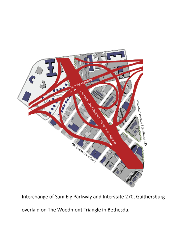
How we spend our time and land is up to us, and next time someone tells you a place is walkable because it has brick sidewalks and street trees, ask them about scale.
GK
I think scale and relationship are important and integrated. Sometimes the comparison between wildly different things–like the interchange–is compelling and other times the similarity between things you never would have compared is useful.
I have often compared the aerial of Bethesda Woodmont Triangle and (zooming out to encompass the CBD, Wisconsin, Edgemoor and East Bethesda) and a comparable area in Beverly Hills, where Wilshire and Santa Monica intersect and a triangle is formed. The retail district bounded by the triangle is bisected by Rodeo Drive.
The scale, configuration, and relationship to neighboring residential in these two downtowns is uncanny. Travel further out wilshire through a condo canyon in westwood and the similarities of Wisconsin Ave slipping out of DC and through Montgomery County is apparent.
The sad news (for montgomery, at least) is that the LA metro version may deal with the same issues more successfully.
I wonder how the scale of North Bethesda’s Rockville Pike compares to favorable examples and what this says about future plans?
Woodsider
Fascinating comparison of two places one would never thing to compare! BTW, the link is broken to “someone else”.
claudia kousoulas
Thanks, I fixed the link, cehck out this great map site
Douglas A. Willinger
In 1996 I lived with a friend in downtown Bethesda and found it could take 20 minutes to go about 6 blocks on Wisconsin Avenue at 5PM.
Amazing that we allow the public good to be subverted by quickie real estate development over comprehensive planning.
Your illustration is but a reminder that Bethesda could have built the NW Freeway almost entirely within the footprint of all of the WMATA induced development built alternatively with air right developemnt for a better utilization of land.
And as for interchanges, please see the tag “Alexandria Orb” at my blog “A Trip Within The Beltway”.
claudia
I don’t think there’s actually anything wrong with 20 minutes-6 blocks-5pm. That’s downtown at rush hour. You can walk from one end of the Betehsda CBD to the other in about 10 minutes. It’s your choice.
But there’s a place for freeways and a place for downtowns. My point is that a place built at a freeway or car scale (like Germantown)is hard to make dense and walkable.
Walkable means more than landscaped.
Douglas A. Willinger
Think about the developement about a century ago along the blocks to the north of NYC’s Grand Central Station.
Please do recall that a great deal of the intelligensia was once agast at the idea of urban railroads, with the above project proving them wrong.
Stuart
Building a nice downtown city on top of the sam eig highway interchange. Brilliant idea!
GK
The New Central development of Park Avenue is remarkable, as is the entire planning of Grand Central as a transit hub. The property values generated above are equally remarkable and arguably the 2 finest office towers of the 20th century sit diagonally opposite each other (Seagram and Lever).
Boston’s Central Artery will show what’s possible over a depressed highway.
However, these are extraordinary examples that don’t offer much help. Also they miss the point of this blog which is that scale matters. Its one thing to draw trees and paths and buildings and imagine that you have created a place and another to actually pull it off.
Think of 2 examples: Rockville’s latest town center and Science CIty.
The former within a few square blocks has all the nice pedestrian, mercantile urbanism that we come to expect, but can this be extrapolated without interruption along the length of Rockville Pike? At this density and vitality, not a chance.
Science City is a vast tract of mediocre buildings. Any drawing that overlays trees and pedestrian links is pure artifice.
Finally, an underlying point to some comments is that we don’t think big, comprehensively, or forward. This is true. The current Purple line is a good example of this, a timid, marginal project. The real Purple Line should have been and underground rail link further out in an arc aligned with Grosvenor, and Rock Spring. This would have been an alignment that could very easily have been taken across the Beltway to Tysons Corner and its link to Dulles.
Two related benefits: the equipment would have been the same, meaning you could hop on a quick train form Bethesda to Dulles. and another major node currently off the grid–montgomery mall and rock spring would be connected by rail. Unfortunately Montgomery County has forgotten how to think big.
GK
We can build on top of interchanges quite easily. I’m not sure that is the point here.
The New Central development of Park Avenue is remarkable, as is the entire planning of Grand Central as a transit hub. The property values generated above are equally remarkable and arguably the 2 finest office towers of the 20th century sit diagonally opposite each other (Seagram and Lever).
Boston’s Central Artery will show what’s possible over a depressed highway.
However, these are extraordinary examples that don’t offer much help. Also they miss the point of this blog which is that scale matters. Its one thing to draw trees and paths and buildings and imagine that you have created a place and another to actually pull it off.
Think of 2 examples: Rockville’s latest town center and Science CIty.
The former within a few square blocks has all the nice pedestrian, mercantile urbanism that we come to expect, but can this be extrapolated without interruption along the length of Rockville Pike? At this density and vitality, not a chance.
Science City is a vast tract of mediocre buildings. Any drawing that overlays trees and pedestrian links is pure artifice.
Finally, an underlying point to some comments is that we don’t think big, comprehensively, or forward. This is true. The current Purple line is a good example of this, a timid, marginal project. The real Purple Line should have been and underground rail link further out in an arc aligned with Grosvenor, and Rock Spring. This would have been an alignment that could very easily have been taken across the Beltway to Tysons Corner and its link to Dulles.
Two related benefits: the equipment would have been the same, meaning you could hop on a quick train form Bethesda to Dulles. and another major node currently off the grid–montgomery mall and rock spring would be connected by rail. Unfortunately Montgomery County has forgotten how to think big.