This blog post is also published as a Greater Greater Washington guest column.
Anyone who has walked, bicycled, or used a wheelchair along major Montgomery County roads as traffic whizzes past uncomfortably close has faced the results of a 1950s-era planning goal: Move as many cars as quickly as possible.
Anyone who has struggled to pay our soaring rents and home prices has felt the impact of our severe housing shortage, a result of single-family zoning laws that restrict our ability to efficiently use the county’s dwindling available land.
Meanwhile, we continuously hear from residents who want to live and work close to transit stops. They want “complete communities” with stores, parks, and daily needs within a safe and convenient walk, ride, or roll. They want to have options for how they commute and reach other parts of the county and the DC region.
That’s why corridor planning presents a path for prosperity.
Corridor-focused growth is one of the most powerful tools we have for shaping inclusive, resilient, thriving connected communities. By allowing for more compact growth around existing and future transit lines and commercial corridors, these areas can reach their full potential as vibrant, walkable, transit-friendly communities that support small businesses, reduce reliance on cars, and provide more housing options at different price points. This approach aligns housing, jobs, and infrastructure to support our environment and grow our economy in a way that benefits everyone, not just a few.
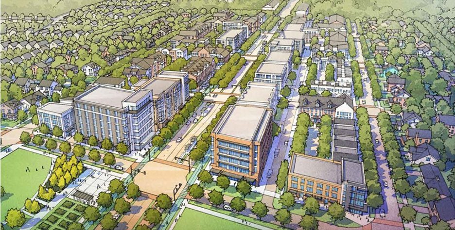
Rendering of a growth along a corridor with moderate-to-high intensity development
After three years of intense community engagement and careful review, the Montgomery Planning Board recently sent to the County Council a draft plan for a portion of University Boulevard corridor. It’s the first such plan since Thrive Montgomery 2050 made corridor planning a key part of its vision for a more accessible, equitable, and environmentally resilient county.
Here’s what a three-mile segment of the University Boulevard corridor between Wheaton and the Four Corners area of Silver Spring could look like: Residents could have housing options that meet their incomes. This could take a few forms. In some parts of the corridor, it would mean duplexes and triplexes where there used to only be single-family homes. It also might look like housing above street-level stores and restaurants fronting a BRT line and clustered around five BRT stations. Larger high-density residential projects would be required to include below-market units.
Increasing the housing supply also would help keep overall home prices and rents in check throughout the area. Wider sidewalks and a network of walkways and bikeways would carry people between parks, shops, and homes—with bushes and trees buffering pedestrians and cyclists from passing traffic. Shade trees would protect people at bus stops from the blistering summer heat.
Additionally, if we want safer streets, we need smarter land use—and that means viewing upzoning not only as a housing strategy, but as a public safety imperative. The urgency is clear: from 2015 through 2024, there were 38 severe injury crashes and four fatal crashes along University Boulevard between Wheaton and Four Corners alone.
Major corridors like University Boulevard, Veirs Mill Road, and Georgia Avenue are more than just conduits for cars. They’re lifelines for pedestrians, cyclists, transit riders, and small businesses. Yet too often, these corridors are dominated by low-density zoning that limits the kind of vibrant, walkable development that makes streets safer. When we concentrate growth along these corridors, we create the conditions for Complete Streets—where every mode of travel is safe and prioritized. Upzoning isn’t just a zoning change. It’s a commitment and an incentive to building corridors that are safe, inclusive, and thriving. If we want to see real change on our streets, we need to align our transportation and land use strategies to make it happen.
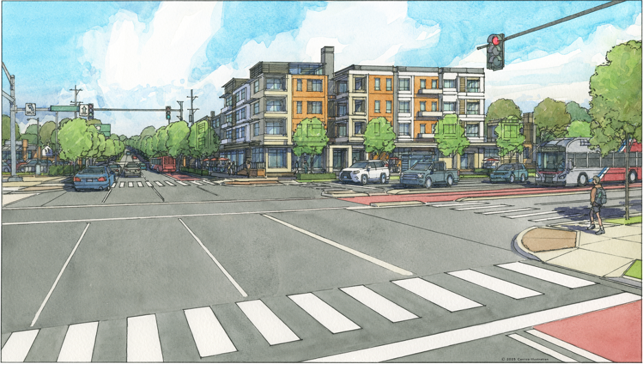
Illustration from the draft University Boulevard Corridor Plan showing corridor planning concepts in the Four Corners area
Of course, the idea of focusing growth along and around major roads isn’t new. That general approach dates back to at least the county’s 1964 Wedges and Corridors Plan, a plan that helped create much of the county our residents love to live in today.
Encouraging higher-density housing near corridors will require changing zoning laws that restrict much of our land, even properties fronting major thoroughfares, to single-family homes. While at the same time, the height and size of any new buildings in the blocks along these roads can be tapered down to ensure compatibility with the single-family home neighborhoods behind them.
With an additional 200,000 people projected to move to, or be born in, Montgomery County over the next 30 years, and limited unconstrained land in the county, we need to ensure that they—and all of us—have enough affordable places to live, plenty of protected green space, and safe, convenient ways to get around without having to drive. Allowing increased densities for infill and redevelopment along our corridors (and in our activity centers) provides the best opportunity to meet our future housing needs in an efficient and sustainable way.
Upzoning our multimodal corridors is more than a land use adjustment—it’s a strategy for building safer, more vibrant communities. As urban planner David Dixon of Stantec notes in a recent CNU Public Square Journal article, density that’s thoughtfully designed, walkable, and strategically located is “an essential catalyst for enhancing economic vitality, environmental sustainability, and places that bring [people] together to celebrate shared community.” Montgomery Planning’s vision embraces this approach, recognizing that when we allow more people to live, work, and gather along key corridors, we create the momentum for pedestrian safety improvements, transit investment, and public spaces that truly serve everyone.
As we begin such planning for our next corridor, along Georgia Avenue, we appreciate that every corridor is unique. We also know that different communities in the same corridor can—and should—accommodate different degrees of development based on whether they’re urban, suburban, or more rural. We understand, for example, that downtown Wheaton can absorb more intense development than suburban Olney farther out. Some corridor segments, especially between future BRT stations, might be recommended for only moderate growth, or none at all.
Expect to see us out and about. Hearing about the kinds of neighborhoods our residents want is foundational to the planning process. While drafting the University Boulevard Corridor Plan, we knocked on more than 1,000 doors and held dozens of public meetings and small group conversations to seek public input at every step in the process. And we are just getting started.
After all, corridor planning will work through the details in the same way our master planning always has—community by community, with the people and businesses that call it home.
 About the author
Jason Sartori joined Montgomery Planning in January 2016 and served as the Chief of the Countywide Planning and Policy (CPP) Division from 2019 to 2023 before his appointment as Planning Director in 2023. Jason previously served as the Associate Director of the National Center for Smart Growth at the University of Maryland. While there, he led numerous projects related to affordable housing, transportation modeling, opportunity accessibility metrics, economic development, and growth visioning and scenario evaluation.