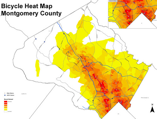
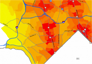
Planners in Montgomery County are working to determine how to best accommodate bicyclists as the county continues to grow. They’ve created a tool known as a “heat map” to figure out the best places to invest in bike infrastructure.
With limited funds, planners have to prioritize bike infrastructure, just like other types of infrastructure. This tool should help planners figure out which projects will have the biggest impact.
As expected, the primary bicycle hot spots are in the more urban communities in the downcounty area. Silver Spring, Bethesda, and Friendship Heights top the list of areas with high cycling demand.
Wheaton, White Flint, and Rockville also have high demand for cycling infrastructure.
The map was developed by measuring proximity to trip attractors such as Metro stations and public facilities. Density and the mix of land uses also factored into the analysis.
Montgomery is the third jurisdiction in the region to develop a bicycle demand map. It follows efforts in the District of Columbia and Arlington County, to develop demand maps for locating Capital Bikeshare stations.
Planners will be able to use this tool to prioritize Capital Bikeshare stations, bike lanes, and other cycling facilities.
We’re still looking for input into the methodology. If you have ideas about how to improve the study, please share them.
Crossposted on Greater Greater Washington.


Bob
When I worked in downtown DC, I biked from Woodside Park to the Silver Spring Metro station using Second Avenue and Spring Street to get into the neighborhood. Now Second Avenue has a bike lane, at least near Spring Street, but the recent lane painting and bumping out of curbs near intersections has made Spring Street much more dangerous for bicycling. I’d hesitate to take that route now. Bikes are forced out into narrow lanes full of cars.
The recent painting of a lane on westbound Spring between First and Second Avenue is a prime example. Instead of creating a bike lane along side the parked cars, they painted a yellow line that is supposed to force auto traffic away from the grass median and right next to the parked cars. Where are bike riders supposed to ride safely with such a configuration? The lines should be repainted so the cars go along the median and there is a bike lane between the parked cars and the lane for auto traffic.
Woodsider
Bob, that would require the MCDOT to coordinate with others silly.
Ian Cooper
One idea would be to use a biking hotspots map that didn’t crash the latest versions of both Internet Explorer and Firefox.
Ian Cooper
After seeing a bunch of recent studies showing that bike lanes are actually more dangerous to cyclists than an unmarked road, I avoid bike lanes (including that one on 2nd Ave) like the plague. In my opinion, 1st Avenue and Spring Street are much better for getting into town.
Bike lanes push cyclists off to the side of the road where they’re less visible to other road users, which may be one reason they’re less safe. Sure, bike lanes make cycling seem safer, but the actual accident statistics tell a different story. Many cyclists regard bike lanes and bike paths as death traps.
Ian Cooper
Whenever you have a narrow lane, take it! Taking up a lane is perfectly legal if there’s not enough room for cars to pass safely. There is no law stating that a motor vehicle has a right to travel at a certain speed. If you’re in front of traffic, you have the right of way and drivers must slow down until they can pass safely. In my view, narrow busy lanes are some of the best for cycling, because traffic tends to be slow and cyclists can control the lane.