Following the adoption of Thrive Montgomery 2050 in 2022, the big question on our minds at Montgomery Planning has been – what’s next in terms of implementation? Thrive, the county’s updated General Plan, has big implications on how we grow as a county in the decades to come and marks a shift in how we plan. As we began developing Montgomery Planning’s new Strategic Plan, which outlines internal goals and objectives over the next five years, we realized we need to look at the department’s structure to position our organization for that shift.
We felt the timing was right to do so. The last time we had a comprehensive organizational structure update was in 2011. A lot has changed in our county and in the world since then. This reflection revealed where we lacked flexibility to address today’s challenges and tomorrow’s opportunities.
I’m excited to announce significant changes to how we operate as a department. I believe that these changes will better position us to ensure we are providing the best service we can to the county’s residents and our stakeholders, as well as meeting the call of Thrive and our strategic plan. This reorganization will be effective July 1, 2025, and while we are committed to providing communities and partners with the same level of customer service and innovative planning solutions, you may be working with some new faces.
New planning regions
To better align with the corridor-focused growth that Thrive calls for, we are reorganizing our geographically based planning divisions. These divisions oversee the development of neighborhood-level master planning efforts and development review. Our new planning divisions will be the West County Planning Division, the East County Planning Division, and the Upcounty Planning Division.
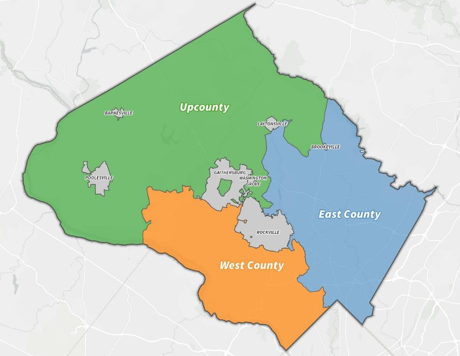
In addition to making more spatial sense, these boundaries better align our work with Thrive’s vision and allow us to focus on the priorities and connectivity opportunities most important to their planning areas:
-
- Upcounty: Agricultural initiatives, regulatory cases, and master plans.
-
- East County: Corridor planning and a strong master plan and development review portfolio.
-
- West County: Master plan implementation and connections across existing plans along the MD 355 corridor.
The updated boundaries offer the four new functional-focused divisions important channels through which to advance their work, too.
New Structure
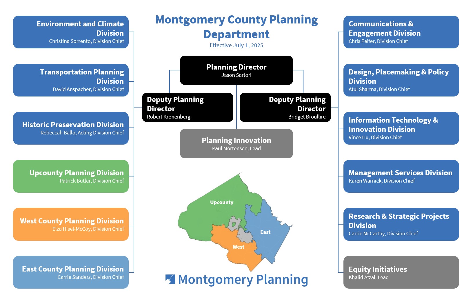 Montgomery Planning’s new internal structure reflects our focus on Thrive’s vision and the ways we actually work and serve the county. To put a greater emphasis on the important countywide work Montgomery Planning does, we’ve created four new divisions:
-
- Design, Placemaking and Policy: Combines the housing, infrastructure, and zoning teams with urban design staff to implement Thrive’s vision for design, placemaking, and housing.
-
- Historic Preservation: Responds to the increased volume of this team’s work, particularly relating to racial equity and social justice and understanding historic inequities.
-
- Transportation Planning: Ensures consistency in transportation initiatives and development application reviews, and aligns multimodal, Vision Zero, and “complete streets” efforts.
-
- Environment and Climate: Unites environmental and forest conservation staff to address climate change and promote resilience.

The Wheaton Placemaking Initiative’s Wheels in Wheaton activation turned a parking lot into a temporary roller-skating rink and a public gathering space. Thanks in part to the success of the department’s placemaking activities over the last decade, Montgomery Planning’s new Design, Placemaking and Policy Division will launch as part of the new structure for the department.
These new divisions complement the following existing divisions that won’t experience much change: the Research and Strategic Projects Division, the Information Technology & Innovation Division, the Communications and Engagement Division, and the Management Services Division. Internally, we will more overtly prioritize staff development, collaboration, and coordination and emphasize intention, transparency, and integrity in all community engagements. That lets us maximize efficiency, impact, and innovation across operations, and deliver outstanding planning for Montgomery County.
New benefits
This restructuring is about realizing a more efficient, reliable, flexible, and consistent department that builds stronger community relationships by fostering trust across smaller and more focused geographic and topical areas. Thrive’s vision of a sustainable future centered on complete, walkable communities will be built on our mission-driven, forward-thinking planning initiatives. What’s more, these adjustments enable better connections to the community, because we’re now set up for success today and tomorrow.
Staff will also have more opportunities for cross-training and interdepartmental collaboration, making for more robust planning and nuanced community relations and exposing employees to more diverse job functions.
What’s next
Looking ahead, county residents will start to see our enhanced operations play out in the Fiscal Year 2026 work program, which also begins July 1, 2025 and includes:
-
- Burtonsville Employment Area Minor Master Plan Amendment
-
- Kensington Sector Plan Amendment
-
- Housing Needs Assessment and Preferences study
-
- Retail Market Analysis and Strategy Update
-
- Green Streets Guidelines
-
- Locational Atlas Update
With these structural updates, we’re positioning Montgomery County for a brighter, more resilient future by reshaping our organization to better and more efficiently serve the evolving needs of the county and pursue Montgomery Planning’s vision of thriving, resilient communities for everyone today and in the future.
Watch my briefing to the Planning Board on June 26, 2025, about Montgomery Planning’s new structure.

About the author
Jason Sartori has been the director of Montgomery Planning since November 2023. He joined Montgomery Planning in 2016 and led the Countywide Planning and Policy Division starting in 2019 before being appointed director by the Montgomery Planning Board. Jason previously served as the Associate Director of the National Center for Smart Growth at the University of Maryland.
Catherine Gallagher
Thank you for this presentation and explanation.
You mention the 355 corridors and neighboring communities as being one focus of the west county processes and planning.
Our neighborhood is profoundly tied to and affected by 355, though it has been carved out of this west county planning.
We need to be heard in this conversation because of traffic patterns and development. It is South Kensington (Parkwood) and withing walking distance to 355 – many of us use the 355 path to the Metro and we must cross 355 (where fatalities of pedestrians have tragically occurred) and fight daily battles with the wild U turn use it’s wild U-turn. Our neighbors south of us are included, as are those to the north.
Can you please explain why we can’t be part of this concerted effort around 355. We are not a part of an incorporated town and have little representation but every interest in having a say in its development, planning, and safety. Thank you
Jason Sartori
Thank you for your comment. When we identified the geographic focus of our new regional planning teams, we primarily used existing master plan boundaries. This approach allows single planning teams to become intimately familiar with the master plans and their corresponding communities. The area of Kensington that you note is part of the 1989 Master Plan for the Communities of Kensington-Wheaton, which is quite large and extends well into the East County Planning Division. While we need to have divisions to organize our department and work, we recognize that major corridors (like 355) and their impacts may extend beyond the division boundaries. When conducting planning efforts along these corridors, our project teams will include neighboring communities regardless of division boundaries and will work to craft a comprehensive vision for the corridors under the principles outlined in Thrive Montgomery 2050.
Bruce
Can you provide a map with road overlay? The colored blobs aren’t clear about boundaries.
Jason Sartori
Thank you for your comment. We’ve updated this blog post to include an interactive map with labels for the neighborhoods of the county and roads. You can also find more details about plans and projects happening in each community on this page: https://montgomeryplanning.org/planning/communities/
Mitsuko Herrera
First, from a public information access perspective, was this Regional Planning reorganization announcement posted as part of the Planning Board’s News on the Planning Board’s site? I came across this information from a friend’s Facebook post of a shared MoCo360 article. When I tried comment using my email account, I received a notice from Google that MoCo360’s Discus gmail comment option does not comply with Google’s security features. I went to the Planning Board site and didn’t see any information it in Planning Board News for June 2025 and when I searched “Planning Regions” it turns up articles from 2024 and 2022. I appreciate the information, but since this blog is reporting information you provided to the Board, it seems like it should be more accessible on the Planning Board site. I went back to the MoCo360 facebook post and they linked to this blog. It would be better if I did not have to know about this blog to find the blog and the reorganization information. If I just missed the information, I apologize.
On a substantive note, there is wisdom to combining development in Silver Spring with Wheaton and East County. But the lack of attention to the Purple Line corridor development is a glaring ommission. We are spending $9.5 billion to connect Bethesda to Silver Spring (to Takoma Park to New Carrollton) and there is nothing in the Planning Regions to address the enormous opportunity and importance of connecting the Bethesda and Silver Spring/Takoma Park urban areas together. From workers to housing to integrated communities. We are going to end up with over a decade of Silver Spring Transit Center and Purple Line construction only to have the Planning Board not even make a passing mention that downtown Silver Spring has any connection to downtown Bethesda.
The Planning Region reorganization also has the unintended consequence of placing the the wealthiest and likely least diverse areas of the county into the West County Planning Region. If not for the inclusion of the City of Rockville, would any areas of the West County include any areas as Moderately or Slightly Disportionally Disadvantaged on the Planning Board’s Communty Equity Index? Your blog states that Historic Preservation, “particularly relating to racial equity and social justice and understanding historic inequities” is one of four new divisions, but your Regions continue the historic Sundown town dividing line of use Rockcreek Park for reviewing and planning development. And there does not seem to be any understanding as to how continuing this north-south tradition might hold back the county, i.e., not thinking of Darnestown and North Potomac as part of greater Gaithersburg, not having Rockville, Aspen Hill, and Olney in one conversation, not talking about downtown Silver Spring, West Silver Spring, Chevy Chase, and Bethesda in the same transit conversation.
Moreover, you might reconsider moving the historic Black community of Unity into East County to join Sunshine and Brookville and Sandy Spring. Even though nothing really remains of Sunshine or Unity, if there is going to be any focus, it is more like to come if Unity stays as part of the Sandy Spring African American Freedom Trail for planning purposes.
Finally, will there be attention or focus in the Regional Planning work on the Highly Disportionally Disadvantaged areas that will existing only two of three Regions(Upcounty and East County) if these problems are not related to Historic Preservation? The Community Equity Index is not mentioned and it is not clear if the Equity Initiatives will support more than Historic Preservation, which is the only place in the text where equity is mentioned. I hope so. Because under Thrive Montgomery 2050, Highly Disportional Disadvantaged area will have attention to creation of transit friendly apartments and condos, with 20-30% set aside for the lowest income families. But there will also be many people in these areas who want an affordable single family home with a yard. Maybe even in an area served by the Purple Line. And I hope Montgomery Planning will have some focus on this corridor too.