The recent downsizing of federal agencies is having a real and immediate impact on Montgomery County—displacing workers and leaving many with uncertain futures. These changes are difficult, especially for those whose livelihoods have long been tied to federal employment. At the same time, this moment calls on land use planners to think strategically about what comes next, as it may no longer be a given that the federal government will occupy the same building and campus footprints that it has in the past. If certain federal properties are no longer needed for government use, we may have an opportunity to reimagine how these sites could serve our communities in new ways. This blog provides an overview of federal property in the county and raises some ideas for redevelopment that could transform federal land into new housing, economic, and community hubs.
Federal property in the county
The federal government owns or leases nearly 6,800 acres of land in Montgomery County, which includes space for federal agencies, the U.S. Postal Service, and parkland along the C&O Canal.1 Federally owned buildings in the county exceed 15 million square feet.2 For scale, this amount of land is approximately 12.6 times the size of Wheaton Regional Park. The amount of reported building space is roughly equivalent to 15 Montgomery Malls.
To better understand the amount and distribution of federal property in Montgomery County, Montgomery Planning’s Research and Strategic Projects Division created an interactive web map. This format allows users to zoom in to different parts of the county and see the location of federally owned and leased spaces, U.S. Postal Service properties, and federal park properties. Selecting parcels provides a box with information on property size, land use, zoning, and assessed value. For leased properties, it shows the amount of space leased to the federal government. For the 31 leased properties in the database, the average percentage leased to the federal government is 55%. Thirteen properties are over 90% leased by the federal government.
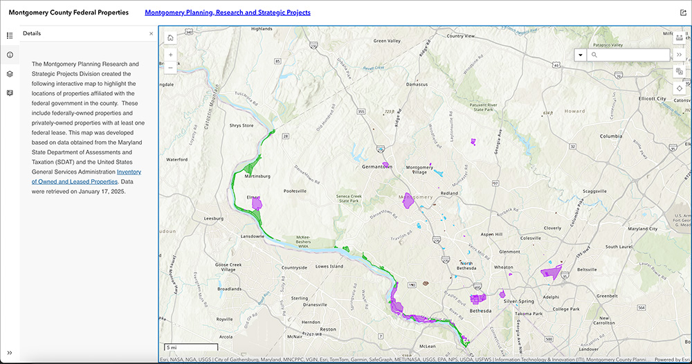
A few observations from the map:
- Federal properties are dispersed broadly around the county. Several large campuses dominate owned properties. Leased properties are concentrated in business districts near Metro stations. Communities across the county could be impacted by changes to federal property use, with leased buildings still likely to become vacant first.
- The zoning on federally owned properties most often reflects the zoning of adjacent areas, not the existing land use. For example, the NIH campus in Bethesda is zoned R-60. This means that redevelopment into commercial uses would require zoning changes.
- Several areas with owned properties are adjacent to leased properties, including the Nuclear Regulatory Commission buildings in White Flint and the NOAA buildings in Downtown Silver Spring. Successful redevelopment may require assembling the entire complex.
- There are some oddities in parcel sizes and configurations, such as a road on the FDA site in White Oak that was originally platted as part of the White Oak Hills subdivision in 1937 was later dedicated to the FDA campus.
 The NOAA complex includes buildings owned by the United States (purple) and a private entity (blue).


Shrinking the federal footprint
The federal government’s desire to occupy less space is not new. For over a decade, the U.S. General Services Administration (GSA) has been focused on freezing and then reducing the federal footprint. Initially, these efforts were oriented around consolidating leased space into owned space. The new administration is poised to even more aggressively reduce the size and the amount of space occupied by government agencies. In February, the GSA posted a long list of facilities for disposition that included several major sites like the Department of Energy building in Germantown and the NOAA headquarters building in Downtown Silver Spring. It was quickly taken down and acknowledged to be premature, but GSA and the Public Buildings Commission have said they continue to review federal property aggressively to look for disposition opportunities.
The shedding of federal employment and space creates significant challenges for the county in the short term, but could also create opportunities in the long term. Federally owned property is tax-exempt, so redevelopment could be an opportunity to return it to the property tax rolls. As Montgomery County is nearly built out, the redevelopment of federal property could provide a new source of large, consolidated land with some existing infrastructure in place to support badly needed housing or other community facilities in central locations.
Successful planning through uncertainty and economic disruption requires developing and maintaining a positive and achievable vision for the future. Rather than sit back and be reactive, is there an opportunity for Montgomery County and Maryland to proactively and strategically pursue federal property for local control and private development that best supports our community needs and economic development goals?
Some ideas for consideration:
- What would it look like if the Forest Glen Annex were redeveloped as a mixed-income community with incubator spaces for small businesses close to the new Purple Line?
- What would it look like if the Department of Energy property in Germantown supported light industrial or advanced manufacturing sectors?
- How could portions of NIH or NIST campuses be redeveloped as centers for life sciences, additional medical facilities, new housing, and community uses (such as an arena)?
- What would it take for the NOAA headquarters campus to be converted into a university or a high school on top of the Metro in Downtown Silver Spring?
Recent redevelopment examples
There is a precedent for the redevelopment of federal property in the county. The National Park Seminary in Forest Glen was owned by the Army from 1942 until 2004 and is now a residential community in a mix of new and rehabilitated buildings. The U.S. Postal Service has disposed of many buildings over the years—the former 20910 post office site on Second Avenue in Silver Spring is now home to the Fenwick apartments. Several Nike Missile sites in Gaithersburg have been repurposed into parks and new housing.
The view from Linden Lane through National Park Seminary show a mix of housing in new and rehabilitated buildings. Image source: Google Street View.
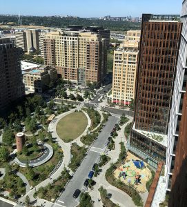
View of renovated Water Park in National Landing from the top of Metropolitan Park, part of Amazon’s new HQ2. Photo credit: James Lee
Numerous communities across the United States that lost major military installations through the Base Closure and Realignment (BRAC) process provide precedents for successful revitalization following economic disruption caused by significant federal downsizing. With effective planning, strong leadership, and targeted capital investment, many communities have overcome such challenges, transforming former military properties into thriving mixed-use developments that include technology centers, housing, social services, and tourism, among other uses. Locally, National Landing is another example of an area that navigated the economic disruption from BRAC after the military vacated a large amount of leased office space. Key factors for success include public-private partnerships, collaborative development of a long-term plan with the community, and a collective commitment to a set of goals for the area.
Federal facilities have long been an important component of Montgomery County’s economy and land use. Yet, the role of the federal government may change in the future. While disruption creates many challenges, it also presents an opportunity to reconsider the distribution of federal space and possibly identify areas where property could be better suited for local use. Montgomery Planning’s new interactive map serves as a starting point for conversations that could lead to the next innovative idea about how federal property could be used in the future.
1 Property data is from the Maryland State Department of Assessment and Taxation (SDAT) and the General Services Administration as of January 17, 2025.
2 Actual building size figures are likely higher due to lack of information for many federally owned sites.
 About the author
Carrie McCarthy is the Research and Strategic Projects Division Chief at Montgomery Planning. She oversees the team responsible for providing demographic, economic, housing, real estate, and forecasting analysis to support land use policy decisions. In addition to serving as co-director of Thrive Montgomery 2050, she has overseen research on master plan implementation, demographic trends, neighborhood change, and economic development. Prior to joining the department in April 2016, Carrie worked at the intersection of real estate and economic development, providing analyses and strategic guidance to inform master plans of complex sites, including former military bases, brownfields, downtowns, and transit-oriented developments.
Data analysis and mapping completed by Luke Savonis and Colin McNamara.