
The Montgomery County Planning Department, in cooperation with the Metropolitan Washington Council of Governments (MWCOG), recently developed a new forecast of population, households and employment from 2010 to 2045. These data-based forecasts are used by government entities and the private sector for various uses, including transportation, water and air quality modeling, and analyzing commercial and residential markets. This latest forecast, known as Round 9.0, is a major reassessment of assumptions made about people, households and jobs in the county.
The draft Round 9.0 forecast anticipates that Montgomery County households, defined as occupied housing units with related or unrelated persons, are expected to increase from about 374,800 in 2015 to 461,900 in 2045, an increase of 87,100 households or 23 percent. The county population, which includes persons living in households and group quarters, is also forecasted to grow from 1,015,300 to 1,223,300 persons over the same 30-year period. This increase represents a growth of about 208,000 persons or 20 percent. Likewise, employment in Montgomery County is expected to expand from about 520,000 jobs in 2015 to 678,700 jobs in 2045, an increase of 158,500 jobs or 30 percent. Figure 1, below, displays the draft Round 9.0 growth forecast for households, population and employment.
Figure 1. Round 9.0 Forecast of Employment, Households, and Population

Over the next 30 years, Montgomery is expected to maintain its status as the second largest county in the region with about 461,900 households, only exceeded by Fairfax County, VA. This ranking is in keeping with the 2015 estimate of households when Montgomery County ranked second in size with 374,900 households. Montgomery County’s expected growth in new households between 2015 and 2045, at 87,100 households, is the third largest regionally.
Figure 2. Round 9.0, Regional Household Forecast

Likewise, Montgomery County is expected to maintain its status as a major regional jobs center. By 2045, the County is expected to have the third largest number of jobs, at approximately 678,700. The County is also expected to rank third in employment growth in the 2015 to 2045 period with a net increase of 158,500 jobs. Only the forecasts for the District of Columbia and Fairfax County assume greater employment growth.
Figure 3. Round 9.0, Regional Employment Forecast

Of course, not all growth is expected to occur uniformly throughout the county. Different neighborhoods accommodate different densities of residential and commercial uses that yield household, population and employment growth. For planning purposes, Montgomery County is divided into 33 policy areas. A policy area is defined as “a geographic sub-area of the county delineated by the Planning Board and adopted by the County Council in the Growth Policy for the purpose of staging analysis and the establishment of transportation staging ceiling capacities.” When the forecast is analyzed at the planning policy area-level, household growth varies across the county. From 2015 to 2045, household growth is expected to be most pronounced along the Interstate-270 spine, along the Metrorail Red Lines, and the White Oak vicinity (see Map 1). The 10 policy areas likely to see the greatest growth in households, in descending order, are:
- White Flint with a net increase of about 8,500 households
- City of Gaithersburg with growth of 7,300 households
- Bethesda and Silver Spring Central Business Districts (CBD), each with 6,400 households
- Clarksburg with 5,900 households
- White Oak with 5,100 households
- Wheaton CBD with 4,700 households
- Twinbrook with 3,600 households
- City of Rockville with 3,500 households
- Research and Development (R&D) Village with 3,200 households.
Map 1. Household Change from 2015 to 2045 by Policy Areas
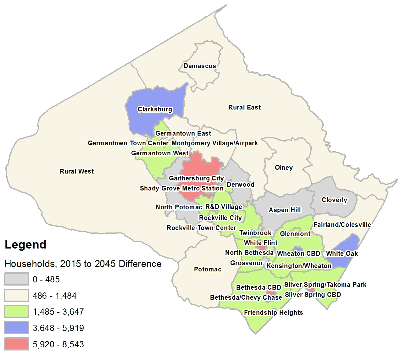
Note that the subarea estimates do not take into account the impact of any in-progress master plans, which may change the envelope of allowable development and densities.
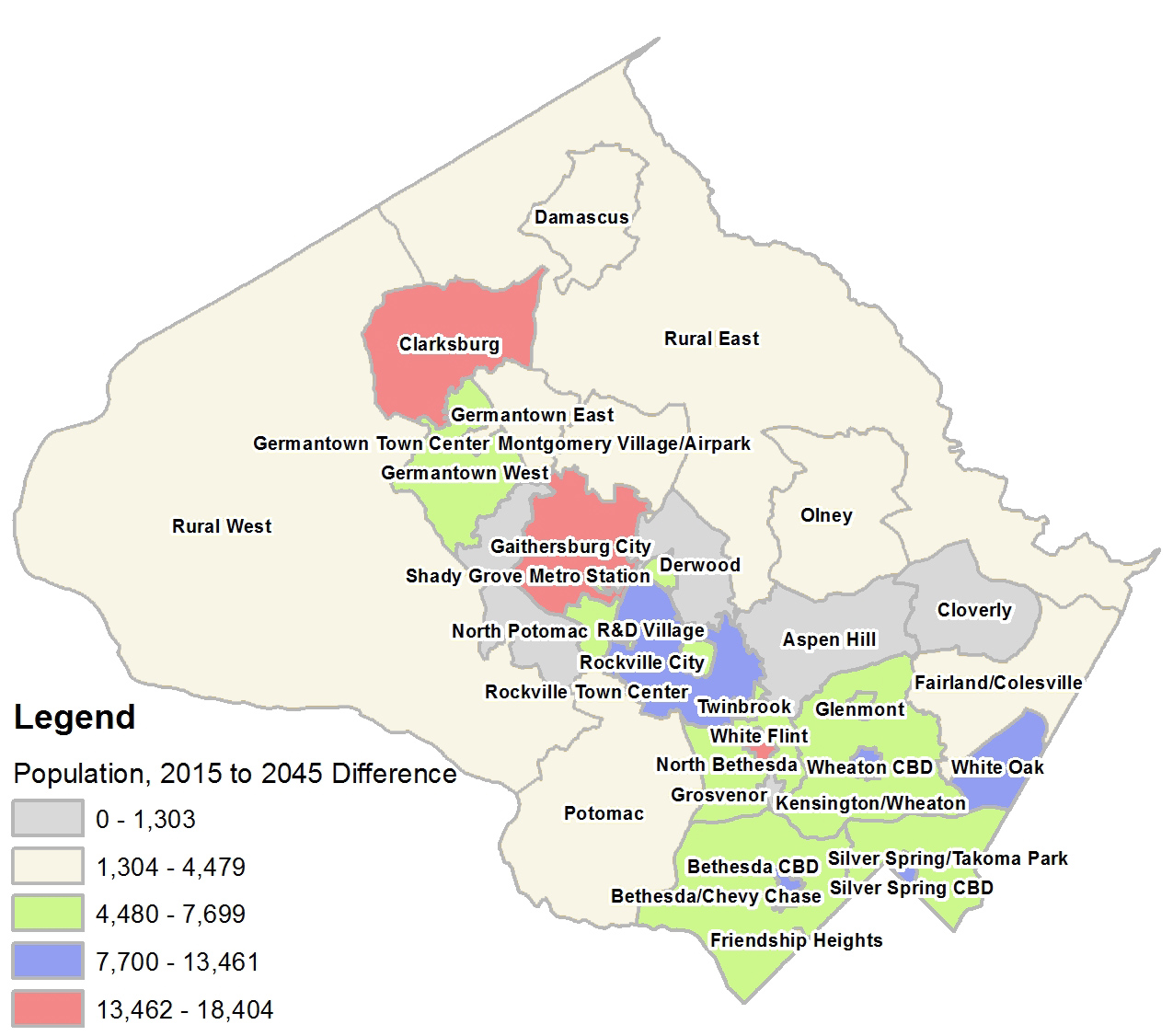
The pattern for population growth is similar to that of households—unsurprisingly, given that households represent the occupied units where related or unrelated persons live. In the 2015 to 2045 time-frame, the top 10 policy areas by population gain are expected to be the following:
- City of Gaithersburg with about 18,400 persons
- White Flint with 17,900 persons
- Clarksburg with 17,100 persons
- Bethesda CBD with 13,500 persons
- Silver Spring CBD with 13,300 persons
- White Oak with 11,400 persons
- Wheaton CBD with 10,000 persons
- City of Rockville with 9,200 persons
- Twinbrook with 7,700 persons
- R&D Village with 7,500 persons.
Map 2. Population Change from 2015 to 2045 by Policy Areas
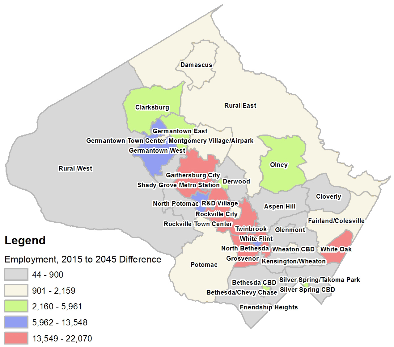
Likewise, employment growth is expected to vary across the county. Map 3, below, shows the expected employment change from 2015 to 2045 at the policy area level. Much of the growth is expected to occur in policy areas along I-270, the northwest portion of the Metro Red Line, and in the far eastern portion of Montgomery County, in the White Oak vicinity.
The top 10 policy areas for forecasted net job growth, in descending order, are:
- White Oak with a growth of about 22,100 jobs
- City of Gaithersburg with 18,600 jobs
- City of Rockville with 15,100 jobs
- North Bethesda with 14,800 jobs
- R&D Village with 13,500 jobs
- White Flint with 10,700 jobs
- Germantown West with 9,500 jobs
- Twinbrook with 8,500 jobs
- Clarksburg with 6,000 jobs
- Silver Spring CBD with 5,600 jobs.
Map 3. Employment Change from 2015 to 2045 by Policy Area
The locations for employment and population growth reflect the current and expected future market desirability of policy subareas based on current and planned infrastructure and transportation access. For example, the White Flint area is currently an attractive market for employment and household growth based on its access to Metrorail and I-270 highway and the appeal of its amenities, such as retail and entertainment venues at Pike & Rose. As a result, this area is undergoing transformative growth, which is expected to continue with a pipeline of about 2,900 multi-family residential units, 2 million square feet of office space and 517,200 square feet of retail space approved and not yet built.
Other areas, such as the Great Seneca Science Center, do not have significant active construction projects currently, but they have potential to accommodate future employment and household growth with planned future investments. The forecast assumes that the catalyst for future construction activity in such areas will be significant infrastructure investment that provides transportation access other than the automobile, such as was the case in the Bethesda and Silver Spring CBDs with Metrorail. In the case of the Great Seneca Science Center, the forecast assumes that the Corridor Cities Transitway (CCT), a bus rapid transit line, will be functioning between the 2030 and 2035 period, and will spur development by efficiently connecting workers to jobs and making the area desirable for future residents.
Technical Note on Forecast:
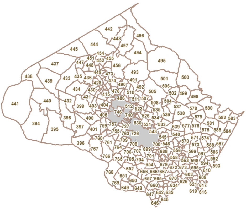
The Montgomery County Planning Department’s participation in the MWCOG cooperative forecasts dates back to 1976. The Round 9.0 forecast is considered preliminary and is expected to become official in November 2016 when the MWCOG Board officially approves. Each forecast is done in cooperation with the Cities of Rockville and Gaithersburg, which perform their own independent forecasts. The forecasts are distributed spatially by Transportation Analysis Zones (TAZ) which are defined as “distinct areas defined by natural or man-made features” according the Planning Department’s glossary of planning terms. Montgomery County has 376 TAZs, of which the Planning Department is responsible for the forecast allocation of 321 TAZs (see Map 4). The rest of the TAZs come under the forecast responsibility of Gaithersburg or Rockville.
Map 4. Transportation Analysis Zones for which the Montgomery County Planning Department does forecast allocation
As a member of the Research & Special Projects Division, Robert Ruiz is responsible for the department’s cooperative forecast and providing master plan teams with demographic and employment information for purposes of understand the plan area’s community and assess future impacts.