Montgomery County
Planning Department
2425 Reedie Drive, 14th Floor
Wheaton, MD 20902
Planning Department
2425 Reedie Drive, 14th Floor
Wheaton, MD 20902
Transportation planners in the Functional Planning and Policy Division:
More information is available on:
 The latest Mobility Assessment Report (pdf, 19MB) is now available.
The 2014 Mobility Assessment Report (MAR) was presented to the Planning Board on April 17. The presentation can be seen here.
Montgomery County's traffic congestion has been stabilizing over the past two reporting periods from 2009-2011 and from 2011-2013 according to the
2014 MAR, a biennial study by county transportation planners that monitors local transportation trends. Click here for the report (pdf, 18MB) and appendix (pdf, 25MB).
See past reports.
The latest Mobility Assessment Report (pdf, 19MB) is now available.
The 2014 Mobility Assessment Report (MAR) was presented to the Planning Board on April 17. The presentation can be seen here.
Montgomery County's traffic congestion has been stabilizing over the past two reporting periods from 2009-2011 and from 2011-2013 according to the
2014 MAR, a biennial study by county transportation planners that monitors local transportation trends. Click here for the report (pdf, 18MB) and appendix (pdf, 25MB).
See past reports.
Find out the latest about the Planning Departments Mobility Assessment Report. Planners Eric Graye and Jose Dory are interviewed about this report which looks at the most congested intersections in the County.
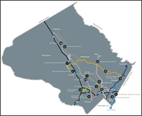 Planners are working on a functional plan on countywide transit corridors to improve accessibility and mobility throughout Montgomery County. The transit corridors study recommends corridors for inclusion in the Master Plan of Highways, based on projected ridership, as well as identifying right-of-way needs.
 The Midcounty Highway (M-83) was first included in Montgomery County’s Master Plan of Highways in the 1960s and is planned to extend from Ridge Road (MD 27) in Clarksburg to Redland Road in Derwood as an 8.7-mile, controlled access, four to six-lane major highway. Over the years, a three mile segment of Midcounty Highway was constructed, between Shady Grove Road and Montgomery Village Avenue. On November 21, 2013, following publication of MCDOT’s May 2013 Draft Environmental Effects Report, the Planning Board received a briefing by MNCPPC staff and Department of Transportation staff and heard public testimony. As a result of the November 21, 2013 briefing and testimony, the Planning Board issued a letter to MCDOT supporting Alternative 9A, the Master Plan Alignment. Additional information on this project is available on the MCDOT project website.
 Download the approved and adopted Purple Line Functional Plan (17MB), a series of recommendations for the proposed transit line’s route, mode and stations. More.
20 members of the Planning Department recently took a city cycling class in partnership with WABA- find out how it went in this Montgomery Plans video segment.
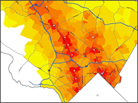 Transportation planners have drafted a Bicycle Heat Map to help the Planning Board and other policy-makers prioritize where to invest in bicycle routes and support facilities. The tool predicts where demand for bike commuting, errands, or other non-recreation trips is greatest. Learn more
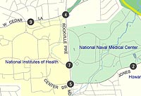 The National Naval Medical Center in Bethesda is undergoing expansion as part of the federal Base Realignment and Closure (BRAC) process. State and county transportation agencies are undertaking nine transportation studies and projects to alleviate the impact of the medical center expansion. Learn more
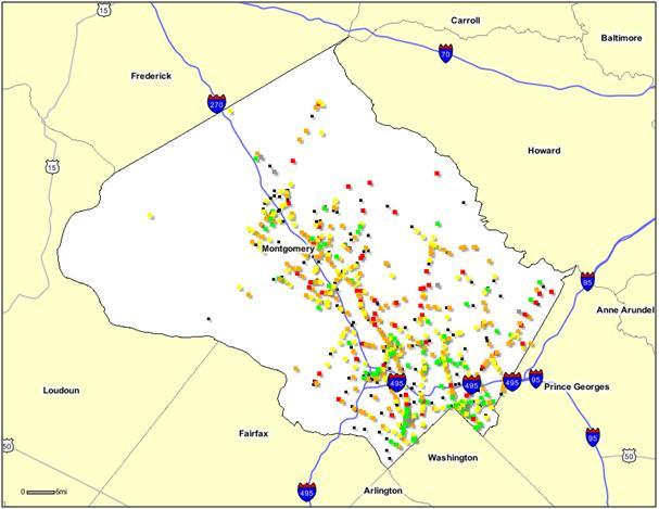 Planners have posted an interactive, user-friendly intersection analysis for anyone interested in countywide intersection traffic counts, and critical lane volumes.
State transportation officials are studying a new transit line — the Corridor Cities Transitway (CCT) — that would extend from the Shady Grove Metrorail Station to Clarksburg. The CCT could become bus or light rail service serving the I-270 corridor. Planners, who see the CCT as a lynchpin for community plans in Germantown and Gaithersburg West, use the CCT station as focal points for clustering houses, jobs, and retail near transit to support uptown activity centers and lessen reliance on automobiles.
 LATR/TPAR guidelines help ensure that development in Montgomery County is accompanied by appropriate, sufficient transportation facilities. The Planning Board and planning staff use the guidelines to estimate the impacts of development on the transportation network and determine effective ways to mitigate that impact. Learn more and download guidelines
Montgomery County Traffic Study Scoping Form
Traffic Study Scoping Form Release Letter
Montgomery County’s Subdivision Staging Policy guides the timing of development and the provision of adequate public services. The policy implements a 1973 law, the Adequate Public Facilities Ordinance, that directs development to areas where public services are in place. The Planning Board helps ensure basic amenities like roads, transit and schools for current and future residents through the Subdivision Staging Policy, which guides matches growth to the availability of public services.
Thomas Autrey
thomas.autrey@montgomeryplanning.org
301-495-4533
Last updated: September 8, 2016