By Katie Mencarini and David Anspacher
Believe it or not, if you’re reading this, you are probably an expert on Montgomery County transportation! Whether you drive to work, ride on a commuter bus, walk to the dry cleaners or bike to school, you know what is and isn’t working, and you have ideas about how to improve the situation. What you might not know is how to communicate those ideas effectively to a transportation planner. We can help. Read on as we cover some of the most common transportation planning terms and tell why they matter.
Most trips people make aren’t for pleasure; they are to get to places. Accessibility is the main way transportation planners describe how many places – shops, jobs, recreation, etc. – a person can get to in a given amount of time. The more places that can be reached, the better. Accessibility can be increased in a few ways:
Americans with Disabilities Act (ADA) “Accessibility”:
Transportation planners and advocates often talk about the importance of making places “accessible”, or traversable for people with disabilities. In this context, the term is referring to specific facilities like curb ramps and audible signals that are important for people with disabilities rather than the number of places that can be reach in a given amount of time.
Mobility. Put simply, mobility describes how far a person can travel in a given amount of time – the speed of travel. One of the reasons why we hear about this so much in this region is because it’s a good way to measure the congestion travelers experience. A roadway that enables high mobility is said to have “free flow” conditions, meaning that traffic moves without delay. A roadway that enables low mobility is said to be congested, meaning there is delay. A common way to increase motor vehicle mobility is to add dedicated turn lanes for automobiles so motorists who need to turn aren’t blocking the road for people going straight. Ways to increase transit mobility include adding a new bus route, reducing the wait between bus arrivals, or putting buses in their own lanes to reduce travel time. For increased pedestrian and bicycle mobility, planners look to widening sidewalks or reducing the time a pedestrian or bicyclist must wait to get a walk signal at a traffic light.
Land Use Proximity. But measuring congestion doesn’t tell the whole story. People travel to get places, and while traveling at faster speeds is one way to make it possible to reach more destinations, another approach is to shorten trip lengths by bringing places closer to people. Reducing the distance between destinations can be achieved by constructing a commercial development project near residential neighborhoods or by mixing building uses together in a single block or even in one building, like we do in our downtown areas (think of an apartment building with shops and restaurants on the first floor).
Connectivity measures the directness of travel, the number of potential routes and travel options. A well-connected transportation network provides multiple routes, with more intersections and fewer dead-end streets, leading to shorter trips. When looking at a map, two places might appear close to each other, but depending on the how the streets are laid out, they may actually be far apart. The grid of streets present in some of the downcounty neighborhoods provides greater connectivity than the cul-de-sac pattern streets of the newer upcounty neighborhoods because they allow for more direct travel. To improve connectivity, we can create a finer grain network of safe streets, walkways, bikeways and crossings.
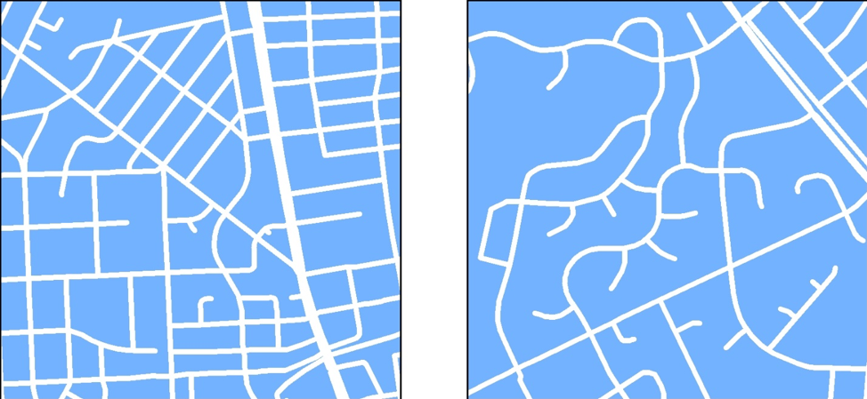
Connectivity is higher in Downtown Bethesda (left), which has a traditional grid of streets, compared to Olney (right), which has a conventional cul-de-sac pattern of streets.
So why should you care about these concepts?
When planners and decision-makers focus on any one of these concepts, it has an impact on how the entire transportation network evolves.
For most of the post-World War II era, planners in this region focused on the mobility, specifically the mobility of people using motor-vehicles, by constructing roads that enable high-speed travel. This went hand-in-hand with the development pattern we have today, where homes are separated from work and other everyday destinations and where high-speed, multilane roads and long-haul transit services such as Metrorail are needed to transport people over longer distances at high speeds. This emphasis on mobility was successful for a time, but over the years as the region was built out, we reached a point where widening the roads had diminishing returns in reducing congestion and where more and more people lacked access to important places unless they had access to a car.
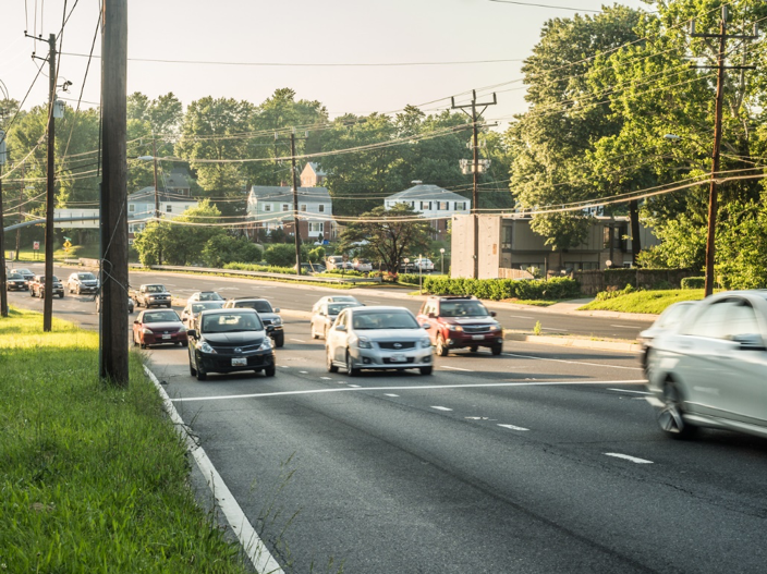
Streets such as Veirs Mill Road have traditionally prioritized vehicular mobility.
A mobility-only approach is not working for Montgomery County
As we mentioned, people do not travel day-to-day just to travel. They travel to get to parks, schools, grocery stores, offices, etc. With that in mind, it is makes sense to use additional tools to plan our transportation system. So, planners are now focused on improving accessibility by targeting land use proximity and connectivity, in addition to mobility.
- Mobility: Projects like the Purple Line and the county’s bus rapid transit network will improve transit mobility and shorten transit trips. Roads such as Snouffer School Road are currently being widened from two to four lanes.
- Land Use Proximity: The county is focused on redeveloping existing downtowns (Bethesda, Silver Spring, Wheaton), retrofitting suburban commercial corridors (White Flint, Life Sciences Center) and developing new commercial centers (White Oak) to bring jobs, shopping and recreation opportunities closer to residents.
- Connectivity: In redeveloping our commercial areas we are implementing a more fine-grained network of streets, bikeways, and walkways.
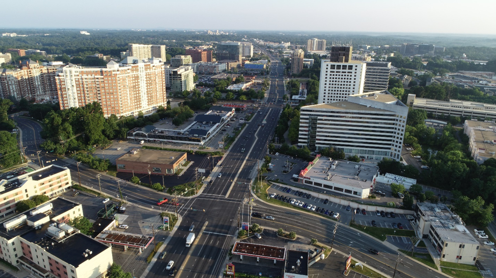
White Flint is transitioning from a conventional suburban commercial center to an urban downtown.
Why talk about all of this now? Thrive Montgomery 2050 is a policy document that will guide the work plan of the Planning Department for the next 10 to 20 years. It will make recommendations for studies, plans, and reports that will influence land use development and transportation projects over the next 50 years. With this project under way, now is the time to make sure we develop thoughtful goals and objectives that reflect today’s values, because the plan will shape how the county looks and moves for decades to come.
Now that you’re familiar with the lingo, we want to hear from you! Please share your ideas about the future of Montgomery County. Or, if you want to learn even more about transportation planning terms, check out our video on roadway expansion and induced demand (why widening roads doesn’t necessarily lead to less traffic congestion).
Robert Smythe
All that sounds good, but it doesn’t reflect reality. Downtown Bethesda is approaching near-constant gridlock, yet county planners keep approving more residential and commercial high-rise buildings with more parking and thus more traffic. Businesses such as Euromotorcars are allowed to use already-congested Arlington Road as their personal parking space for car carriers to load and unload, constricting traffic to one lane, often during rush hours. Pedestrians are given short shrift as sidewalks are blocked for weeks or months to allow developers to load, on load, and store building materials. To call this “planning” is a cruel joke.
David Helms
You are what you measure. If you start with the wrong measure of effectiveness, the architecture you build WILL be wrong. Distilling “mobility” down to time between two points completely misses the human dimension of the issue and therefore a key objective: quality of life in terms of health outcomes. The county needs to focus on providing a built environment for our residents (at a liveable wage) enabling a healthy active lifestyle which reduces metabolic diseases, reduces the occurrence of asthma by removing particulate matter (eliminating combustion) from the air, promote a healthy ecosystem by removing chemicals (pesticides and plastics) from our environment.
David Helms
… mobility (or lack thereof) directly [motor vehicle ER visits] and indirectly [diabetes ER visit, heart disease ER visit, suicide mortality, diabetes mortality, heart disease mortality] impacts health outcomes. The health outcome achievement is disproportionate across the county; therefore, lack of access to mobility contributes to inequality in the county.
https://www.montgomerycountymd.gov/HHS/Resources/Files/Reports/Health%20Equity%20Report_HM%20Core%20Measures%202008-2017.pdf