Yesterday, I discussed the potential zone restructuring in the Montgomery County zoning rewrite. The series continues today with an overview of our thoughts on the mixed-use and commercial areas of the county.
These areas are an important part of the county. They are where residents shop and work. But in many cases their design reflects outmoded, unsustainable thinking, with strip shopping centers and office parks surrounded by acres of parking.
This model won’t continue to work for Montgomery County as our population grows, demographics shift, and we run out of developable land. The county must find ways to leverage the infrastructure of these areas.
One approach to solving this problem is with the Commercial-Residential (CR) Zones. The CR Zones are a family of mixed-use zones comprising a variety of densities, heights, and mix of uses.
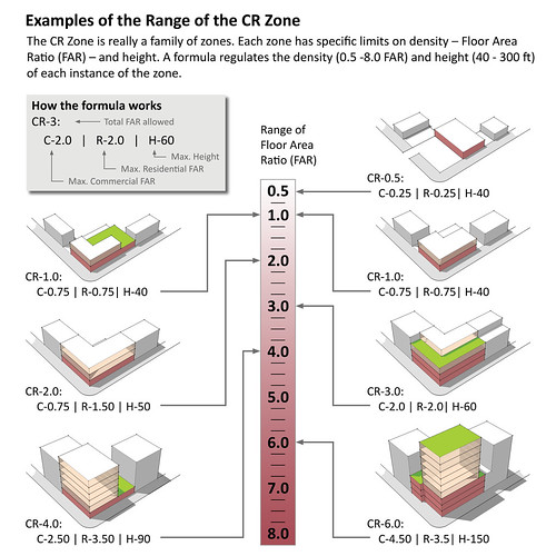
Each CR Zone is defined by four factors indicated in the zone name: CR, C, R, and H. These symbols correspond to overall allowed density (CR), maximum non-residential density (C), maximum residential density (R), and maximum height (H).
Density is measured using Floor Area Ratio (FAR), which is essentially a measure of bulk. For example, a building that is one-story tall and takes up its entire lot has an FAR of one. If the same building were two-stories tall but took up only half of its lot, it would still have an FAR of one. You can read more about FAR here.
The graphic below explains the range of CR Zones in density and height:

Now, it’s important to note that the above graphic does not represent what is possible on the same lot. Each of these examples represents what development could look like in different zones based on the CR designation. The CR-6.0 building at bottom right could not be built in the CR-0.5 zone at top right. But the CR-0.5 building at top right, a standard method of development, could be built in any of the denser zones.
Let’s consider another example. What could we build if a parcel was zoned CR-4.0 | C-3.0 | R-3.5 | H-50?

Because developers can only achieve the maximum density by mixing uses, they have an incentive to do so. This will improve the mix of uses in our activity centers. Other regulatory elements will ensure better urban design by putting parking behind structures and encouraging the inclusion of public amenities.
Implementing of the CR zones during rewrite project will not increase densities or heights beyond what exists now without comprehensive review and public input, as required by law. Increasing the density of a parcel is something that belongs in the planning process, not the coding process.
Currently, the highest density allowed in the county is 8.0 FAR, which is only allowed in the CBD-3 zone. Those zones are adjacent to the Metro stations at Bethesda, Silver Spring, and Wheaton.
The map below shows existing (and draft conversion) densities for the CR Zones throughout the county. Note the range of colors. The CR Zones are not uniformly dense and do not necessarily represent an “up-zoning.”

Crossposted at Greater Greater Washington
Matt
cr zone theoretically works great for conversion of suburban properties in areas such as white flint but have considerable shortcomings for small properties. this is due to the regulation of density through FAR.
small lot, fragmented land ownership in bethesda, silver spring, etc. mandates regulation in other ways than FAR otherwise just a 3-5 story building is what you will get (and most of those cannot work financially due to structured parking costs). if we want higher performance out of our precious metro sites than FAR stinks if you are less than 20k lot size (= approx. 4-5 story building).
for lots less than 20k, height/form should be the regulating factor on density.