Montgomery County
Planning Department
2425 Reedie Drive, 14th Floor
Wheaton, MD 20902
Planning Department
2425 Reedie Drive, 14th Floor
Wheaton, MD 20902
The Master Plan is completed and the new zoning has been implemented!
 The consolidation of the Food and Drug Administration (FDA) at the White Oak Federal Research Center (FRC) provided an opportunity for the county to re-examine its long-term goals and objectives for the area.
The approved and adopted Master Plan provides the foundation upon which the area can evolve into a community that offers more local opportunities to live, work and play. The Plan envisions White Oak's major centers -- Hillandale, White Oak and the Life Sciences/FDA Village -- evolving from conventional, auto-dependent suburban shopping centers, business parks and light industrial areas into vibrant, mixed-use, transit-served nodes.
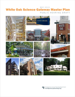
NEW - Click here to view the approved and adopted White Oak Science Gateway Master Plan. The zoning recommended in the approved and adopted Master Plan became effective on October 31, 2014.
Click here to view Design Guidelines for the White Oak Science Gateway Master Plan, which were approved by the Planning Board on November 6, 2014.
The County Council approved the Resolution adopting the White Oak Science Gateway Master Plan on July 29, 2014 -
The Planning Board and the M-NCPPC adopted the Master Plan on July 31, 2014.
View the version of the White Oak Science Gateway Master Plan with the Planning Board's revisions from December 2013 - Report
The Planning Department provided an overview of the Planning Board Draft Master Plan to the County Council on June 17, 2014 (presentation). The Council's Planning, Housing, and Economic Development (PHED) Committee held worksessions on the Master Plan on July 1, 7, and 16. The full County Council held a worksession on July 22 and voted to approve the Resolution aopting the Plan on July 29.
The County Council held a public hearing on the Master Plan on Tuesday, February 4, 2014, at 7:30 p.m. at the Council Office Building at 100 Maryland Avenue, Rockville, Maryland. Click here to view Planning Board Chair Carrier's transmittal letter to County Council President Rice.
The documents that were pertinent for the public hearing:
Click here to view the September 2013 Planning Board Draft of the White Oak Science Gateway Master Plan.
Click here to view the REVISED pages of the Planning Board Draft Master Plan (approved by the Board on December 19, 2013).
Click here to view the Planning Board's proposed amendments to the 2012-2016 Subdivision Staging Policy (approved by the County Council on November 13, 2012) that support recommendations in the Draft Master Plan.
After holding seven worksessions, on September 19, 2013, the Planning Board approved the White Oak Science Gateway Master Plan for transmittal to the County Council and County Executive. On October 2, 2013, the Council President requested that the Board address the land use-transportation balance issue and prepare a package of recommendations that would allow the Council to approve a balanced Plan. Click here to see the Council President's letter.
The Planning Board held additional worksessions on December 5, 12, and 19, 2013. On December 19, the Planning Board approved revisions to the Planning Board Draft Master Plan and proposed amendments to the Subdivision Staging Policy that address the land use-transportation balance, per the Council's request. The Planning Board also decided to delete the Staging recommendations from the Draft Master Plan. Click here to see all of the documents that were transmitted to the County Council and the County Executive on December 20, 2013, including the transmittal letter, the Planning Board's revisions to the September 2013 Draft Master Plan (Attachment 1), the Board's recommended amendments to the Subdivision Staging Policy (Attachment 2), and additional materials the Board received during the December worksessions.
The Design Guidelines for the Master Plan were presented to the Planning Board on July 25, 2013. Read Design Guideline
View the plan appendix
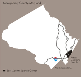
The plan provides a vision and recommendations to guide future growth by amending portions of the 1997 White Oak and Fairland Master Plans. The plan area includes several major properties and developments, the largest of which is the 610-acre Federal Research Center. The FDA occupies 130 acres of the FRC and now has 5,500 employees on site. Adventist HealthCare plans to build a new Washington Adventist Hospital and medical campus on nearly 50 acres along Plum Orchard Drive (pending approval of a Certificate of Need from the State). In addition, approximately 300 acres on two sites (Site 2 and Percontee) near the FRC and Washington Adventist Hospital may provide the potential for economic synergies, as well as the possibility of new housing and retail near jobs. The area’s largest employers are the FDA, Seventh Day Adventist Church, Kaiser Permanente, Holy Cross and Comcast.
The plan also provides recommendations for the National Labor College (located on 46 acres at New Hampshire Avenue and I-495), and the White Oak and Hillandale shopping centers. The need for more community facilities, recreational opportunities, and pedestrian and bicycle links will be explored as well.
In November 2012, the County Council adopted the 2012-2016 Subdivision Staging Policy, which sets the rules for how the Adequate Public Facilities Ordinance is administered at the preliminary plan (subdivision) stage of development. The SSP contains a new transportation test – Transportation Policy Area Review (TPAR), which replaces Policy Area Mobility Review (PAMR).
Given that the plan transportation modeling and analysis completed in 2012 used the PAMR test, the County Council directed the Planning Department to redo the transportation analysis applying the TPAR test. This additional transportation analysis was completed for the staff draft.
Transportation problems, and attempts to solve or relieve traffic congestion, have characterized the eastern county for 30 years. Transportation issues have been a major focus of the planning effort, which explored a range of mobility alternatives – both transit and road infrastructure – that could increase travel options and traffic capacity to allow additional development.
The plan focuses on the future growth of sites within the Life Sciences/FDA Village Center area – particularly Site 2 and Percontee. The adjacent FRC site presents a physical planning challenge, since it is a large, secured facility, which makes it difficult, if not impossible, to truly integrate the campus with adjacent sites to create a walkable, mixed-use center. The planning process examined:
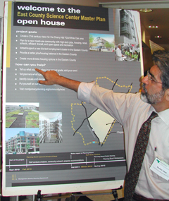 Community planner Khalid Afzal at one of the community meetings on the draft plan.
A Metropolitan Washington Council of Governments (COG) Transportation-Land Use Connection (TLC) Grant provided a consultant to work with staff to explore various transit options. View report (3.2 MB).
A Countywide Bus Rapid Transit Study managed by the County Department of Transportation analyzed the potential demand for BRT service, including routes on Colesville Road and New Hampshire Avenue that would serve the master plan area. The study confirmed the feasibility – from a demand and ridership standpoint – of a network of BRT corridors within the county. In response, the County Council initiated an amendment to the Master Plan of Highways to reflect a network of BRT corridors.
The Countywide Transit Corridors Functional Master Plan was approved by the County Council on November 25, 2013, and officially adopted by the M-NCPPC on December 18, 2013. To view the Functional Plan, click here.
The Planning Board appointed members of a Citizens Advisory Committee to provide input and guidance to planners in developing the plan. The group assisted in developing recommendations for the White Oak Science Gateway Master Plan. The CAC included representatives of groups within the Plan’s boundaries, including community and civic associations, business and property owners, and area organizations and institutions.
In addition to the CAC, community engagement efforts included:
Luis Estrada, 301.495.4641
Luis.Estrada@montgomeryplanning.org
Date of last update: April 14, 2016