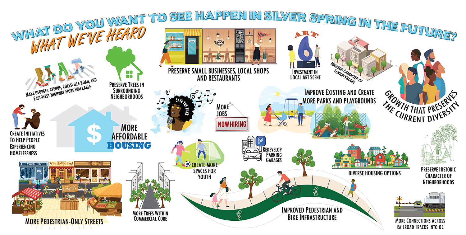
silver spring
Superblocks in Palm Beach
On a busman’s holiday, I had a chance to bicyle around Palm Beach and noticed that, not surprisingly, the one percent get some pretty nice urban design.
But what is surprising is that whether you’re in the one percent or the 99 percent, the bones are the same. Palm Beach’s Worth Avenue was created very much the way Federal Realty does a Bethesda Avenue or Foulger Pratt does an Ellsworth Avenue.
Worth Avenue, Bethesda Avenue, and Ellsworth Avenue are all parallel or perpendicular to the main traffic artery. You get onto Palm Beach island via Royal Palm Way, a spectacularly landscaped boulevard with green median and four travel lanes. But make no mistake, shopping and strolling are a few blocks to the south on the much more intimately scaled Worth Avenue. The same bones are in Bethesda and Silver Spring; the car traffic is out on Wisconsin and on Georgia.
And it points out a lost opportunity in Friendship Heights (which has the bones and the money). Friendship Boulevard and Jennifer Avenue run parallel to busy Wisconsin Avenue, but are lined with parking lots and loading docks instead of using them to create a retail enclave conducive to strolling and cafe lingering. Â
Furthermore, Worth Avenue’s little piazzas and mid-block connections seem to be the accreted decisions of varied builders over time.
It is, in fact, a real estate development created out of assembled properties, just the way our CBD zoning encourages assembly by offering optional method density increases for sites over 20,000 square feet.
It’s what you do with your superblock that makes the difference. Worth Avenue and much of Palm Beach’s (and South Florida’s) Spanish-Mediterranean architectural character was created by Addison Mizner. He didn’t go to architecture school, but did attend university in Salamanca, Spain and apprenticed with a Beaux Arts practice.
In the Beaux Arts, God truly is in the details. From “An American Country House,” a 1925 monograph on the work of Mellor, Meigs, and Howe, this column capital is carefully drawn, scaled, and constructed.
Sure it’s easy if you’re doing a luxurious country house, but these details come from the Bush Terminal Building on 42nd Street and Broadway in New York City as recorded in the 1925  ”Architectural Construction, An Analysis of the Design and Construction of American Buildings.”

and it was not only decorating the building, but knowing how to put it together using the proper scale and materials. No dry-vit here
And one more thing. At the time, Palm Beachers used to clapboard cottages objected to Mizner’s “ugly, foreign-looking buildings.”
As a part of the Purple Line, Montgomery County will fund upgrades to the Capital Crescent Trail between Bethesda and Silver Spring. Tomorrow, the Planning Board will hear recommendations from its transportation planning staff about several issues facing the trail. After hearing testimony, the Planning Board will send recommendations to the Montgomery County Council.
The current design from the Maryland Transit Administration includes a number of improvements to the trail. The upgraded trail will be expanded to 12 feet wide, where feasible, and paved. Additionally, the trail will be extended from its current terminus at Lyttonsville 1.5 miles farther east to Downtown Silver Spring. New overpasses or underpasses will be provided over Connecticut Avenue, Jones Mill Road, 16th Street, and Colesville Road.
This is good news for trail users.
Planning staff is calling for the installation of lighting along the new trail from Bethesda to Silver Spring. The trail would be lit during the hours the Purple Line is open, and would allow the trail to be used safely during commuting hours. The recommendation is to design lighting so that it does not disturb neighboring properties.
Staff is also calling for emergency call boxes to be placed at intervals along the trail. This will help to promote security and reduce crime. New landscaping will help to create a pleasing trail experience and will screen trail users and neighbors from the Purple Line.
The most costly decision that will have to be made is whether to put the trail above the train in the tunnel under Wisconsin Avenue. Right now, estimates place the cost of keeping the trail in the tunnel at $40.5 million, which is 43% of the cost of the entire trail. Planning staff have recommended against putting the trail in the tunnel if the price remains so high. For a fraction of that cost, the surface alignment could be significantly improved. The Planning Department is calling for more study before making a final decision.
Not having the trail in the tunnel would mean that trail users would need to cross Wisconsin Avenue at grade. If a surface alignment is chosen, the staff recommends prioritizing pedestrians and cyclists crossing Wisconsin Avenue. They recommend a working group be convened to hammer out the design details.
A surface alignment is clearly not as nice for pedestrians and cyclists because of the Wisconsin Avenue crossing. But there are plenty of ways to make the crossing of Wisconsin safe and efficient for trail users.
The Planning Department recommends that if the surface alignment is used through Bethesda, that the trail will be made as user-friendly and safe as possible. While the exact design solutions have not been determined, many solutions will be considered, including creating a bicycle/pedestrian only signal phase for crossing Wisconsin Avenue, a separated “cycle track”, raised crosswalks, and more.
And let’s not forget that even if the tunnel under Wisconsin is lost to the Purple Line, the trail will still be vastly improved. It will be paved, bridge several major arterials where people have to cross at grade now, and extend 1.5 miles farther to downtown Silver Spring.
This year, Seaside is 30 years old and whatever you think of Andres Duany and the Congress for New Urbanism, any observer of urbanism must admit that Seaside has changed the vocabulary.
The pattern of main street, grid streets, mixed facades, and public space is part of every Federal Realty project and appears on our own Ellsworth Street.
Along Florida’s Gulf Coast, Seaside neighbors Rosemary Beach, Alys Beach, and the Watercolor resort have picked up the vocabulary and created a sense of place, community, and style along the coast road, 30A.
Duany etal have identified a fundamental human pleasure in strolling a certain type of built space, and have, most importantly, made that space marketable. From Seaside to Kentlands, CNU-style real estate comes in at a high price point and holds its value.
Duany’s strongest message has been empiricism–using experience and evidence to form a community plan–most particularly, American experience and evidence. Planners and designers look wistfully at St. Mark’s Square but the American town, from New England to California, is a perfectly workable and pleasing model.
Paths, porch swings, front doors, a civic buildng, church or otherwise are the small physical markers of human community.
Guest Post by Alex Hutchinson
Whether it’s the Boundary Bridge that straddles Rock Creek right outside Silver Spring or the Cabin John Bridge nestled into Glen Echo, I love the bridges our region boasts. I’m no gephyrophobiac, bridges don’t scare me one bit. But there is one bridge that makes me uneasy–and no, it’s not the Tacoma Narrows– it’s the Downtown Silver Spring Library bridge. Despite the fact the Planning Board voted 8-1 against the bridge, it has once again become part of our local discourse. Here’s why I hope this bridge wobbles into oblivion.
It’s been argued that the proposed bridge is the best and most economic way of achieving accessibility for all. Silver Spring already has a skywalk: the bridge that connects the Ellsworth Drive parking garage to City Place Mall. This post isn’t about the untapped potential of City Place, but it’s worth remembering that the skywalk never transformed City Place into the attraction of Silver Spring it was intended to be.
Skywalks, the ill-conceived circulators dreamed in an era of automobile-centric planning, aren’t necessary in the paradigm of today. In the Board’s discussion, planners made the case that the structure would divert traffic from the active sidewalks and street level retail that have come to define Downtown Silver Spring.
The bridge also would encourage library users to drive, avoiding the highlights of Silver Spring altogether. Skywalks mainly serve drivers who, at some point, leave their cars to become pedestrians. A problem associated with skywalks is the reluctance of pedestrians to use their circuitous routes and instead brave a busy road, in turn running the risk of being struck by a vehicle. Less able pedestrians— people in wheelchairs, mothers with strollers, the elderly –similarly might opt to cross the road instead of taking the elevator up to the third floor of the parking garage. While the library intersection isn’t a tranquil, one-lane country road, removing pedestrians from the equation altogether is heading in the wrong direction.
Paul Holland, of the Washington Area Wheelchair Society, is glad accessibility is being emphasized. In a recent conversation, he thought the bridge wasn’t the only option to improve accessibility for those with limited mobility. In fact, pedestrian bridges can be difficult to climb depending on the grade of the incline. He pointed out that the steep angle of Montgomery College’s pedestrian bridge can be strenuous for non-motorized wheelchair users.
According to Holland, the most important corrections for safe intersections are sight lines, gradients, smooth surface transitions from curb to street, light-timing, and driver behavior. The $750,000 estimated cost of the bridge could be more resourcefully spent in some of these problem areas. With just $120,000, affordable alternatives could turn the intersection into something that would be accessible for everyone.Â
A pedestrian bridge might look good on paper, but one alternative solution might be a Barnes Dance. This year, 7th & H streets in D.C.’s Chinatown became the proud owner of a Barnes Dance Intersection. These intersections use three traffic signal phases. In one, pedestrians cross in all directions, including diagonally. The other two let traffic go in one of the two directions, but prohibit pedestrians from crossing parallel to the traffic. However, not all intersections are created equal, and with the future Purple Line running through this area, the intersection might be too complex for this solution. In addition, teaching drivers to behave in these unaccustomed settings is easier said than done. Pedestrians and traffic officials in the district are already reporting difficulty in enforcing drivers to obey no turn on red signs.Â
One only has to walk around the relocated Fenton Street Market at Veterans Plaza to see the effect of a pedestrian-friendly environment: streets and sidewalks are brimming with artists, merchants, retail, and as a result everyone is more connected to the growing exceptional architecture Silver Spring has to offer. Let’s improve on the Civic Center’s success and learn from the mistakes of City Place.
Alex Hutchinson, a Takoma Park native, is a Planning Department intern. When he’s not applying to graduate schools in Urban Planning you can find him teaching English as a second language, riding his bike on the Capital Crescent Trail, experimenting and failing with the Ride On bus system, or making loud music. Alex became interested in the field of planning after learning about Curitiba Brazil’s Bus Rapid Transit System. If you have any questions or bones to pick please contact him at alexanderehutchinson@gmail.com
End of the Week Links: February 26th
LOCAL
A Visit To Velatis
Silver Spring Singular
SSS samples the caramels from Velatis, which recently opened on Georgia Avenue in a building previously occupied by trees. Mouth watering images included.
Lessons from a South American Bus Rapid Transit system
Greater Greater Washington
Councilmember George Leventhal traveled to Curitiba, Brazil to test out their BRT system. He shares his thoughts with GGW.
It’s Worse Than You Thought… but maybe better too
Friends of White Flint
An interesting recap of where Montgomery County is strong, and where it needs to improve relative to the Washington region.

How Silver Spring Park could be a good neighbor
Greater Greater Washington / Just Up The Pike
Wednesday Eclectica
Thayer Avenue
Two blogs share their thoughts on Silver Spring Park, the project formerly known as the Moda Vista.
Note: This project goes before the Planning Board on March 4th. The planning staff report can be found here.
NOT SO LOCAL
A Plan to Decarbonize Chicago’s Loop
Inhabitat
Adrian Smith + Gordon Gill, the designers responsible for the Willis (Sears) Tower retrofit, have completed an initial analysis of buildings in the heart of Chicago to reduce carbon emissions by 30% by 2020.
Architecture of Healthiness
Next American City
New York City recently came out with their Active Design Guidelines, and is looking at a number of ways to make buildings healthier and more active places to live and work.
Green Roofs Are So Last Year; Rooftop Farms Are The Growing Thing
Treehugger
Treehugger runs through a plethora of examples demonstrating the rising popularity of rooftop gardens.
Earlier this winter, the New York Times ran an article on a CEO’s for Cities study revealing a substantial premium on home sale prices in areas with an above average Walkscore, the informative, if simplistic online measurement tool that ranks neighborhood “walkability” based on proximity to community services and amenities. According to the study, for every additional Walkscore point a neighborhood earns, home prices increase by $700 and $3,000. On average, highly walkable homes sold for $4,000 to $38,000 more than their auto-centric competition.
This past weekend, I attempted to use Walkscore in conjunction with Zillow.com to (at least loosely) confirm the study’s findings for Montgomery County. While zip-code data gave a soft nod in the affirmative, I couldn’t find data fine-grained enough without searching individual listings. I did, however, spend some time seeing how different areas in the County fared on the walkability test.
Not surprisingly, the County’s results range from laudable to loathsome. At the positive end of the spectrum, Bethesda (97), Wheaton (97), and Silver Spring (94), all rank in the top 10% nationwide. They succeed in large part because of their concentration of diverse retail and abundant transportation options. Less exemplary are the Beltway-adjacent areas of Forest Glen (51) and Grosvenor (48) which, despite Metro accessibility, are both physically constrained and poorly served by neighborhood services.
What was most notable about the County is the discontinuity of our walkable fabric. If you own a home three-quarters of a mile west of the Bethesda Metro Station, your Walkscore is probably about 38. Travel the same distance in the opposite direction and you’re likely to earn a score of 55. This trend is pretty consistent throughout the MD-355/Red Line corridor. Worse, though, are the number of pockets in between Metro stations that have diminished Walkscore. This trend suggests that residents and office workers are unlikely to walk to services or use transit without driving to the station (which is still much better than driving to work). Pooks Hill, for example, located just south of the Beltway between the Medical Center and Grosvenor stations barely ekes out a score of 30. As distance between stations increases, this trend becomes increasingly common.
Downtown DC, by contrast, is consistently walkable. According to the CEO for Cities study, DC has a median score 71. A quarter of District neighborhoods score better than 82 on the Walkscore scale, ranking seventh among US cities. Where in Montgomery County the walkable street network extends only a limited distance from Metro, in the District the street network ties together neighborhoods creating a continuous pedestrian environment. As a result, it is just as easy to walk from Adams Morgan to Georgetown where there is no Metro service, as it is to Dupont Circle or Penn Quarter where there is.
Walkscore is also a valuable indicator of a site’s inherently sustainable characteristics. The LEED for Neighborhood Development rating system addresses these considerations in two full sections dedicated to Smart Location and Linkages, and Neighborhood Pattern and Design sections. LEED for New Construction, however, allots only a four points related to walkable site selection (SS 1:Site Selection, SS 2:Development Density & Community Connectivity, SS 4.1: Public Transportation Access and SS 4.4 Parking). Why is this important?

Consider the following buildings in Montgomery County. The first is a LEED-Platinum rated office building just off I-270 with almost non-existent transit service, no proximal services or amenities, and no real concentration of nearby housing. To construct the building, a swath of forest was cleared not only to accommodate the building footprint, but also the parking structure, which incidentally has twice the footprint of the building itself. Its Walkscore is 35.
The second project is the Silver Spring Library, which is scheduled break ground on a site that will eventually serve as a station for the Purple Line light rail system. The library building accommodates ground floor retail, an arts center, additional office space, and a 60,000 square foot library. It sits on a previously developed site, requires no additional parking, will eventually also accommodate 140 residential units, and is located adjacent to the Silver Spring CBD. Its walkscore is 97. The library, however, is projected to only earn a LEED-Silver rating.
According to one study, 30% more energy is expended by workers commuting to a traditional office building than the building itself uses. For an average office building built to modern energy codes, more than twice as much energy is used by commuters than by the building itself. This highlights the importance of building within a walkable framework. You can argue that a “green” auto-dependence is better than the traditional form of auto-dependence, and in the case of Tower Oaks, attractive auto-dependence is better than your run-of-the-mill schlock. But this misses the point. Ultimately, sustainability comes back to a few basic principles. Walkability, and automobile independence, is one.
Other areas in Montgomery County: Olney: 91;Â Friendship Heights: 89;Â White Flint: 80;Â The Kentlands: 78;Â Germantown: 63;Â White Oak: 60;Â Gaithersburg Life Sciences: 55.
Project Profile: The Burnside Rocket
Tacking onto Elza’s post on Silver Spring’s future form, I came across this building a few weeks ago and couldn’t help but think of Fenton Village. It’s cheerful, gritty, and almost certainly would feel at home in a neighborhood that already boasts an array of colors, from the similarly red Pyramid Atlantic to the tastefully pink Jackie’s Restaurant.
And while the Burnside Rocket may seem to offer little in the way of architectural distinction other than a few eccentric shutters painted by local artists (which I think are quite neat), between its crimson painted walls is a powerhouse at work. The LEED-Platinum certified structure is built both to last, approximately 300 years according to the project’s website, and operate efficiently. Hollow-core concrete slabs distribute conditioned air in lieu of metal ductwork. The raw, industrial aesthetic reduces the need for finishing materials and interior partitions. And a ground source heat pump provides efficient indoor air conditioning while desuperheaters recover “waste heat” for domestic water heating. It is also the first building outside Portland’s downtown to not provide parking.
Even more interesting, the roof features an edible garden that is harvested by the restaurant tenant on the top floor. No, the garden is not as photogenic as say, Chicago’s City Hall. In fact it only about half of the green roof is built into the building. But the Burnisde Rocket maximizes its roof space by providing harvestable roof space in the form of “kiddie” pools planted with vegetables, and a planter-lined parapets.
The Burnside Rocket is also an excellent case study on the economic benefits of “going green.” Because of the massive energy savings, estimated at about a 50% reduction from traditional construction, the property owner can offer tenants a full-service lease. Unlike conventional triple-net leases (NNN) where lessee’s pay for all taxes, maintenance, and insurance associated with their tenancy, the property manager assumes these costs and leaves tenants only to account for rent. The result? Property owners can charge more for rent while offering savings when compared with a triple-net lease, and achieve higher profit margins from the reduced operating costs.
Additional Information:
The Greenroof
Green Renter


